Photo Credits (5)
Difficulty
Moderate
Trail Length
2.4 miles
Trail Type
Out And Back
Elevation Gain
350 ft
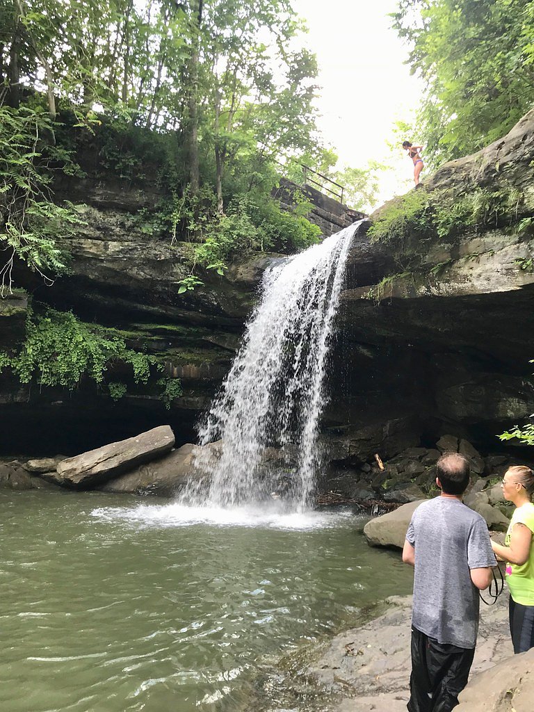
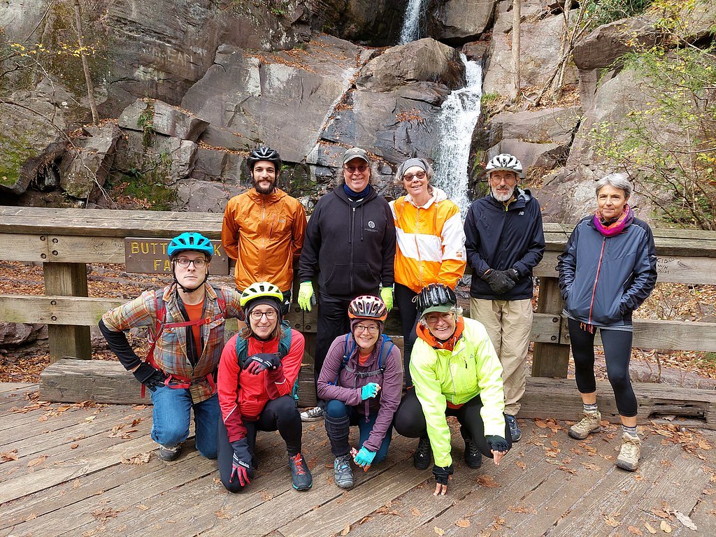
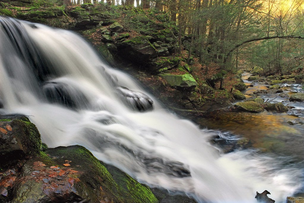
About Buttermilk Falls
Buttermilk Falls is one of several waterfalls that share this popular name (see Wikipedia), and this Pennsylvania site is known for its soothing cascade over layered rock that creates a peaceful, photogenic setting. The falls are often visited for an easy-to-enjoy outing where the sound of tumbling water and the surrounding forest make for a restorative stop on a day hike. The hike to the falls follows a moderately paced out-and-back route that gains about 350 feet over the round trip, making it a good half-day excursion for hikers who want a bit of exercise without committing to a long backcountry route. Trails and conditions can change with the seasons, so plan for slippery rock and mud after rain and bring footwear suited to wet trails.
The Setting
Buttermilk Falls sits at 381 feet along the Brodhead Creek, in the coastal lowlands of Pennsylvania.
Trail & Hike Details
The Approach
The moderate 2.4-mile out-and-back trail gains 350 feet of elevation on the way to the falls.
Trail Description
Trail length: 2.4 miles (out-and-back). Elevation gain: approximately 350 feet. Difficulty: moderate. No specific USFS trail name or number, or detailed USFS surface/grade/class data, was provided for this route. The trail is generally well-defined but can become muddy or slippery after rain, so sturdy, traction-capable footwear is recommended. Expect a mix of forest tread and rocky sections as you approach the base of the falls.
What to Expect
Dogs are welcome.
Accessibility
The trail is not wheelchair accessible. Uneven terrain and elevation changes require steady footing.
Frequently Asked Questions
🐶 Are Dogs Allowed at Buttermilk Falls?
✅ Dogs are allowed
Are There Any Fees or Permits Required?
🆖 No fees required
🏊 Is There Swimming at Buttermilk Falls?
❌ Swimming is not allowed
When to Visit
Spring and early summer are ideal times to visit, as the waterfall flow is typically strongest due to snowmelt and rainfall. Fall offers beautiful foliage, while winter may provide a unique view of the falls if they freeze.
Seasonal Access
The best time to visit is Spring, Summer, and Fall. Winter access may be limited.
Safety Information
Exercise caution on slippery rocks near the falls. Stay on marked trails to avoid damaging the environment or getting lost. Be aware of ticks and other insects in the area.
Current Water Conditions
266 ft³/s
Current discharge — how much water is flowing
About average for this time of year
Based on 75 years of record
1.41 ft
Water depth at gauge
7-Day Discharge Trend
What does this mean for your visit?
Flow is about average for this time of year.
About This Gauge
7-Day Flow Outlook
Based on the USGS gauge Brodhead Creek at Minisink Hills, PA (2 km away).
Today
Roaring
303 cfs
6/10Tomorrow
Strong
285 cfs
9/10Tue
Strong
264 cfs
10/10Wed
Strong
241 cfs
10/10Thu
Strong
249 cfs
10/10Fri
Strong
247 cfs
10/10Sat
Roaring
264 cfs
6/10Best window: Tue — strong flow, mostly sunny (trip score 10/10).
Best time of year: this gauge typically runs highest from late February to mid May, peaking in April.
How we calculate this
This is a transparent outlook, not a precise forecast. We take the waterfall's current flow strength (how it ranks against its historical normal for today, from the nearest USGS stream gauge), carry that ranking forward along the gauge's seasonal curve, and nudge it for forecast rain. Confidence is highest for the next day or two and falls further out. Always check official conditions and your own judgment before visiting — high flows can be dangerous.
Know when to go.
Get a free email alert when waterfalls near Delaware Water Gap hit peak flow. We only send when conditions are worth the trip — no weekly newsletters, no spam.
Weather Forecast
Location & Access
Getting There
Buttermilk Falls is located near Delaware Water Gap, East Stroudsburg, and Arlington Heights. The coordinates for the falls are 41.0098, -75.1321. Visitors can access the falls via local roads, and signage may guide you to the parking area.
Get Directions on Google MapsParking
There is a small parking area near the trailhead, but availability may be limited during peak seasons.
Elevation
381 feet above sea level
Coordinates
41.009817° N, -75.132123° W
Visitor Tips & Gear
Arrive early during weekends or peak seasons to secure parking. Wear sturdy shoes, especially if visiting after rain, as the trail may be slippery. Bring water and a camera to capture the scenic views.
As an Amazon Associate, we earn from qualifying purchases.
With 2.4 miles and 350 ft of elevation gain, sturdy boots and trekking poles will help on this moderate trail. Sun exposure on the trail makes good sun protection a must in summer.

Polarized Sunglasses (Knockaround)
Cuts glare off the water so you actually see the falls — and your photos turn out better too.

Columbia Watertight II Rain Jacket
Packs into its own pocket, seam-sealed, and keeps you dry from spray and surprise rain.

Earth Pak Waterproof Dry Bag
Keeps your phone and gear dry when waterfall mist soaks everything else.

Waterproof Phone Pouch (AiRunTech)
Cheap insurance — take photos right next to the falls without killing your phone.

Timberland Euro Sprint Mid Waterproof
Trusted waterproof boot with premium leather and grippy rubber sole — reliable on rocky, wet trails.

TrailBuddy Trekking Poles
Lightweight aluminum, cork grips, and flip-locks that actually hold — a best-seller for good reason.
Where to Stay

Pocono Mountain Villas MOD Collection by Sonesta

Cozy Corner

The Penn Stroud, Stroudsburg - Poconos, an Ascend Collection Hotel

Staybridge Suites East Stroudsburg - Poconos by IHG
Browse vacation cabins and private rentals nearby
Unique outdoor stays — tents, yurts, and treehouses
Rent a campervan or RV for your waterfall road trip
Some links are affiliate links. We may earn a commission at no extra cost to you.
Nearby Campground
Alosa Campsites
9.6 miles away · 6 sites
Overview The Alosa Campsites are boat-in only sites located on the west (Pennsylvanian) shore of the Delaware River near Bushkill, Pennsylvania. The side of the river with the campsites will be on your right while traveling downstream. This section of the river offers unspoiled views, excellent boating, fishing, and birding opportunities within the Delaware Water Gap National Recreation Area and the Middle Delaware National Scenic and Recreational River. These reservation-only campsites are avail
Book on Recreation.govAdditional Information
Nearby Attractions
Delaware Water Gap National Recreation Area, Bushkill Falls, and the Appalachian Trail are nearby attractions worth exploring.
Wildlife
The area is home to various bird species, deer, and small mammals. Visitors may also encounter insects such as mosquitoes during warmer months.
Cities near Buttermilk Falls
Nearby Waterfalls
Other waterfalls named Buttermilk Falls
22 other waterfalls share this name across the U.S.
-
01
Apalachin
165 ftCurrent flow 71 ft³/s -
02
Claverack-Red Mills
165 ftCurrent flow 128 ft³/s -
03
Cohoes
165 ftCurrent flow 2,410 ft³/s -
04
East Worcester
165 ftCurrent flow 25 ft³/s -
05
Fultonville
165 ftCurrent flow 2,750 ft³/s -
06
Gloversville
165 ftCurrent flow 2,750 ft³/s -
07
Greenwood Lake
165 ftCurrent flow 163 ft³/s -
08
Highland Falls
Current flow 3 ft³/s -
09
Hudson Falls
165 ftCurrent flow 45 ft³/s -
10
Keeseville
165 ftCurrent flow 201 ft³/s -
11
Linwood
165 ftCurrent flow 108 ft³/s -
12
Palenville
165 ftCurrent flow 1 ft³/s -
13
Speculator
165 ftCurrent flow 260 ft³/s -
14
Wampsville
165 ftCurrent flow 44 ft³/s
Writing about Buttermilk Falls? Embed this waterfall on your site for free.