Buttermilk Falls
New York • 165 ft
By Armen Suny · Last verified Mar 2026
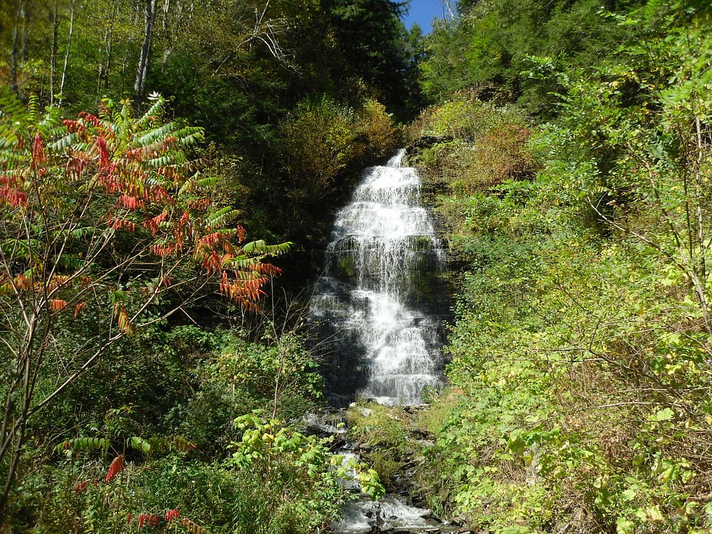
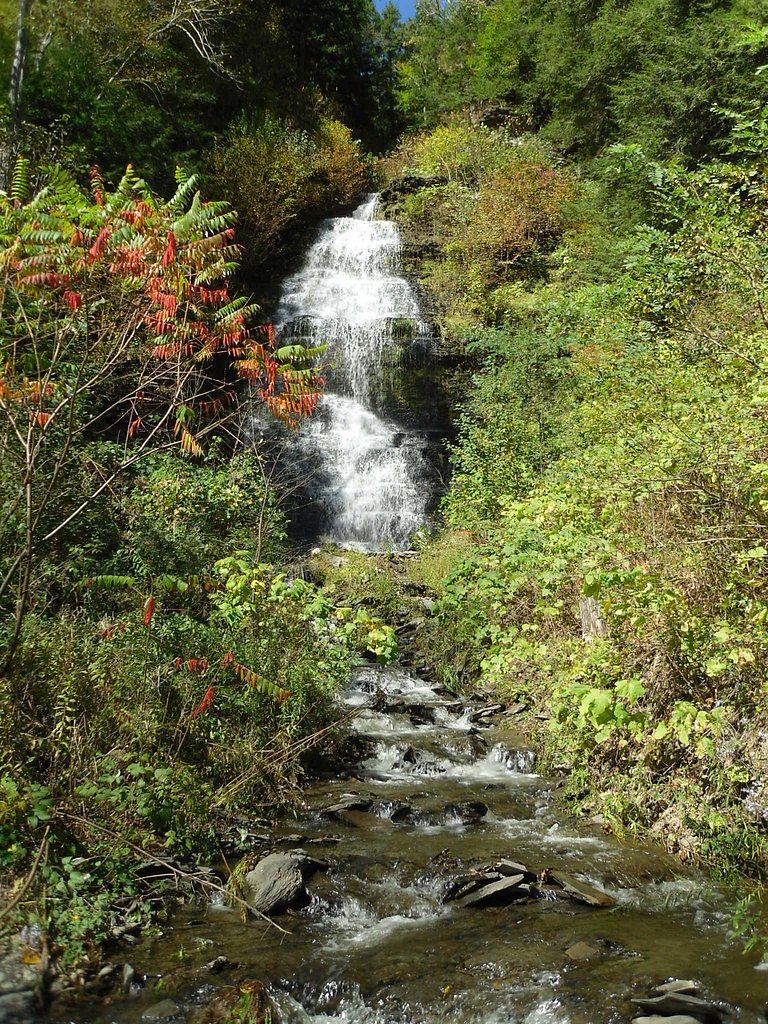
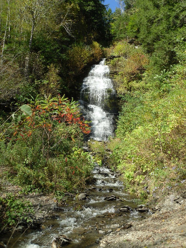
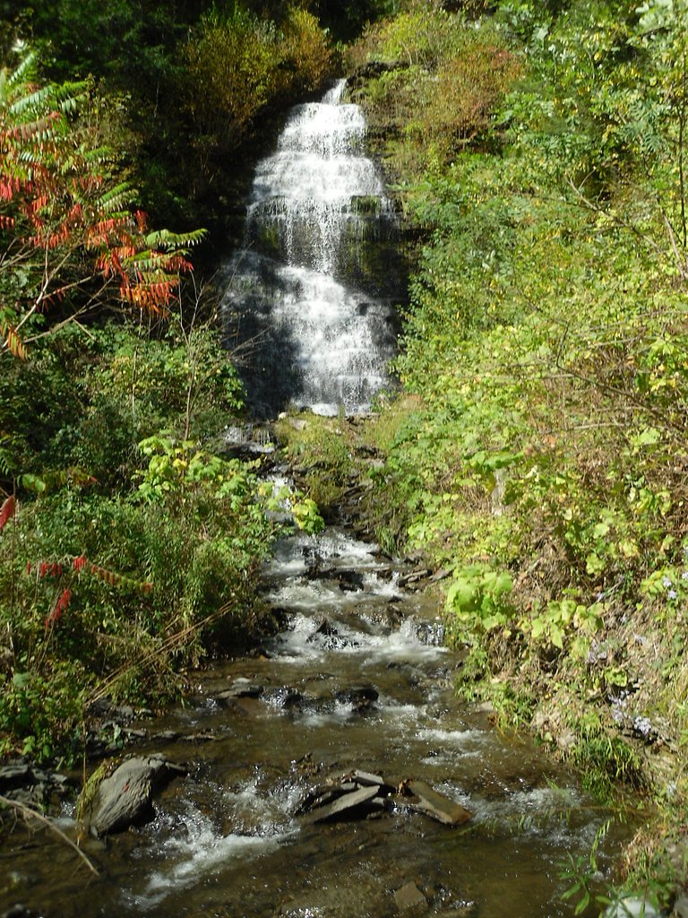
Photo Credits (5)
Difficulty
Moderate
Trail Length
1.5 miles
Trail Type
Loop
Elevation Gain
500 ft
About Buttermilk Falls
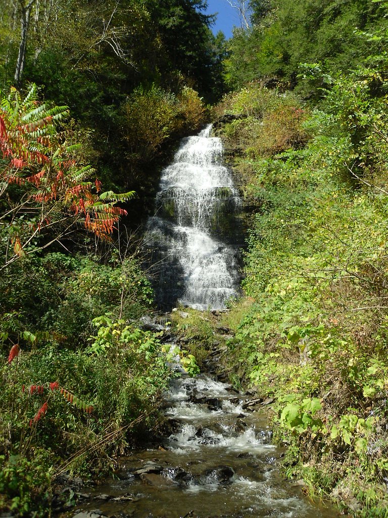
Buttermilk Falls, just outside Ithaca, is a scenic cascade series that culminates in a prominent 165-foot drop tucked into a wooded gorge. Nestled within Buttermilk Falls State Park, the falls are framed by steep limestone walls and lush forest, making the area a favorite for photography, picnics, and a refreshing dose of upstate New York scenery. The park’s popular Gorge Trail forms a roughly 1.5-mile loop with about 500 feet of elevation gain and is rated moderate, so it delivers dramatic waterfall viewpoints without requiring a full-day commitment. Along the way stone steps, bridges, and overlook platforms bring you close to the rushing water and the layered cascades, offering a compact, memorable hike in the Ithaca gorges region.
The Setting
Buttermilk Falls sits at 1,417 feet in the foothills of New York. At 165 feet, it is among the taller waterfalls in New York.
Height: 165 feet
Trail & Hike Details
The Approach
The moderate 1.5-mile loop trail gains 500 feet of elevation on the way to the falls.
Trail Description
Gorge Trail (Buttermilk Falls State Park) — 1.5-mile loop, ~500 ft elevation gain, difficulty: moderate. The trail follows the gorge and provides close-up views of the cascading falls and the main 165-foot drop. Expect built stone steps, footbridges, and multiple viewpoints as you move through the gorge; the route uses stair sections and short connector paths to link scenic overlooks into a loop.
What to Expect
The falls plunge 165 feet. Swimming is permitted. Dogs are welcome.
Accessibility
The trail is not wheelchair accessible. Uneven terrain and elevation changes require steady footing.
Frequently Asked Questions
🐶 Are Dogs Allowed at Buttermilk Falls?
✅ Dogs are allowed
Are There Any Fees or Permits Required?
🤑 Fee: $9.00
🏊 Is There Swimming at Buttermilk Falls?
✅ Swimming is allowed
When to Visit
Spring and early summer are ideal for visiting, as the waterfall flow is strongest due to snowmelt and rainfall. Fall offers beautiful foliage, while summer is popular for swimming in designated areas.
Seasonal Access
The best time to visit is Spring, Summer, and Fall. Winter access may be limited.
Safety Information
The trail can be slippery, especially after rain. Stay on marked trails and avoid climbing on rocks near the falls. Swimming is only allowed in designated areas.
Current Water Conditions
2,490 ft³/s
Current discharge — how much water is flowing
About average for this time of year
Based on 11 years of record
20.68 ft
Water depth at gauge
71°F
ComfortablePleasant for swimming
7-Day Discharge Trend
What does this mean for your visit?
Flow is about average for this time of year. The water is a comfortable 71 degrees F, pleasant for swimming. Mineral content is typical.
Water Quality
Conductance
Dissolved minerals in the water
About This Gauge
This gauge is on a nearby waterway and may not reflect exact conditions at the falls.
7-Day Flow Outlook
Based on the USGS gauge MOHAWK R ABOVE STATE HIGHWAY 30A AT FONDA NY (21 km away).
Today
Moderate
2490 cfs
9/10Tomorrow
Moderate
2458 cfs
9/10Tue
Strong
2959 cfs
7/10Wed
Strong
2630 cfs
10/10Thu
Moderate
2490 cfs
9/10Fri
Strong
2851 cfs
7/10Sat
Roaring
2847 cfs
6/10Best window: Wed — strong flow, mostly sunny (trip score 10/10).
Best time of year: this gauge typically runs highest from early March to late April, peaking in April.
How we calculate this
This is a transparent outlook, not a precise forecast. We take the waterfall's current flow strength (how it ranks against its historical normal for today, from the nearest USGS stream gauge), carry that ranking forward along the gauge's seasonal curve, and nudge it for forecast rain. Confidence is highest for the next day or two and falls further out. Always check official conditions and your own judgment before visiting — high flows can be dangerous.
Know when to go.
Get a free email alert when waterfalls near Gloversville hit peak flow. We only send when conditions are worth the trip — no weekly newsletters, no spam.
Weather Forecast
Location & Access
Getting There
Buttermilk Falls is located in Buttermilk Falls State Park, just south of Ithaca, New York. The park entrance is off Route 13, and the falls are easily accessible from the main parking area.
Get Directions on Google MapsParking
Parking is available at the main entrance of Buttermilk Falls State Park. A parking fee may apply during peak seasons.
Elevation
1,417 feet above sea level
Coordinates
43.134239° N, -74.295413° W
Visitor Tips & Gear
Arrive early during peak seasons to secure parking. Bring water and wear sturdy shoes for the hike. Be cautious on wet or uneven surfaces.
As an Amazon Associate, we earn from qualifying purchases.
With 1.5 miles and 500 ft of elevation gain, sturdy boots and trekking poles will help on this moderate trail. Sun exposure on the trail makes good sun protection a must in summer.

Polarized Sunglasses (Knockaround)
Cuts glare off the water so you actually see the falls — and your photos turn out better too.

Columbia Watertight II Rain Jacket
Packs into its own pocket, seam-sealed, and keeps you dry from spray and surprise rain.

Earth Pak Waterproof Dry Bag
Keeps your phone and gear dry when waterfall mist soaks everything else.

Waterproof Phone Pouch (AiRunTech)
Cheap insurance — take photos right next to the falls without killing your phone.

Timberland Euro Sprint Mid Waterproof
Trusted waterproof boot with premium leather and grippy rubber sole — reliable on rocky, wet trails.

TrailBuddy Trekking Poles
Lightweight aluminum, cork grips, and flip-locks that actually hold — a best-seller for good reason.
Where to Stay

Microtel Inn & Suites by Wyndham Johnstown

Adirondack Waterfront Cabin Upper Hudson Tributary

Super 8 by Wyndham Johnstown/Gloversville

Amsterdam Castle NY
Browse vacation cabins and private rentals nearby
Unique outdoor stays — tents, yurts, and treehouses
Rent a campervan or RV for your waterfall road trip
Some links are affiliate links. We may earn a commission at no extra cost to you.
Nearby Hot Springs
Hot springs near Gloversville, New York

Looking for a soak after your hike? Explore more hot springs near Gloversville, New York on SoakingSprings.
Explore New York springsAdditional Information
Nearby Attractions
Other nearby attractions include Taughannock Falls State Park, Robert H. Treman State Park, and the city of Ithaca with its restaurants and shops.
Wildlife
The area is home to various birds, deer, and small mammals. Keep an eye out for wildlife along the trail.
Cities near Buttermilk Falls
Other waterfalls named Buttermilk Falls
22 other waterfalls share this name across the U.S.
-
01
Apalachin
165 ft -
02
Claverack-Red Mills
165 ftCurrent flow 123 ft³/s -
03
Cohoes
165 ft -
04
East Worcester
165 ft -
05
Fultonville
165 ftCurrent flow 1,420 ft³/s -
06
Greenwood Lake
165 ftCurrent flow 53 ft³/s -
07
Highland Falls
Current flow 2 ft³/s -
08
Hudson Falls
165 ftCurrent flow 40 ft³/s -
09
Keeseville
165 ftCurrent flow 205 ft³/s -
10
Linwood
165 ftCurrent flow 92 ft³/s -
11
Palenville
165 ft -
12
Speculator
165 ftCurrent flow 260 ft³/s -
13
Wampsville
165 ftCurrent flow 42 ft³/s
Writing about Buttermilk Falls? Embed this waterfall on your site for free.