Buttermilk Falls
New York • 165 ft
By Armen Suny · Last verified Mar 2026
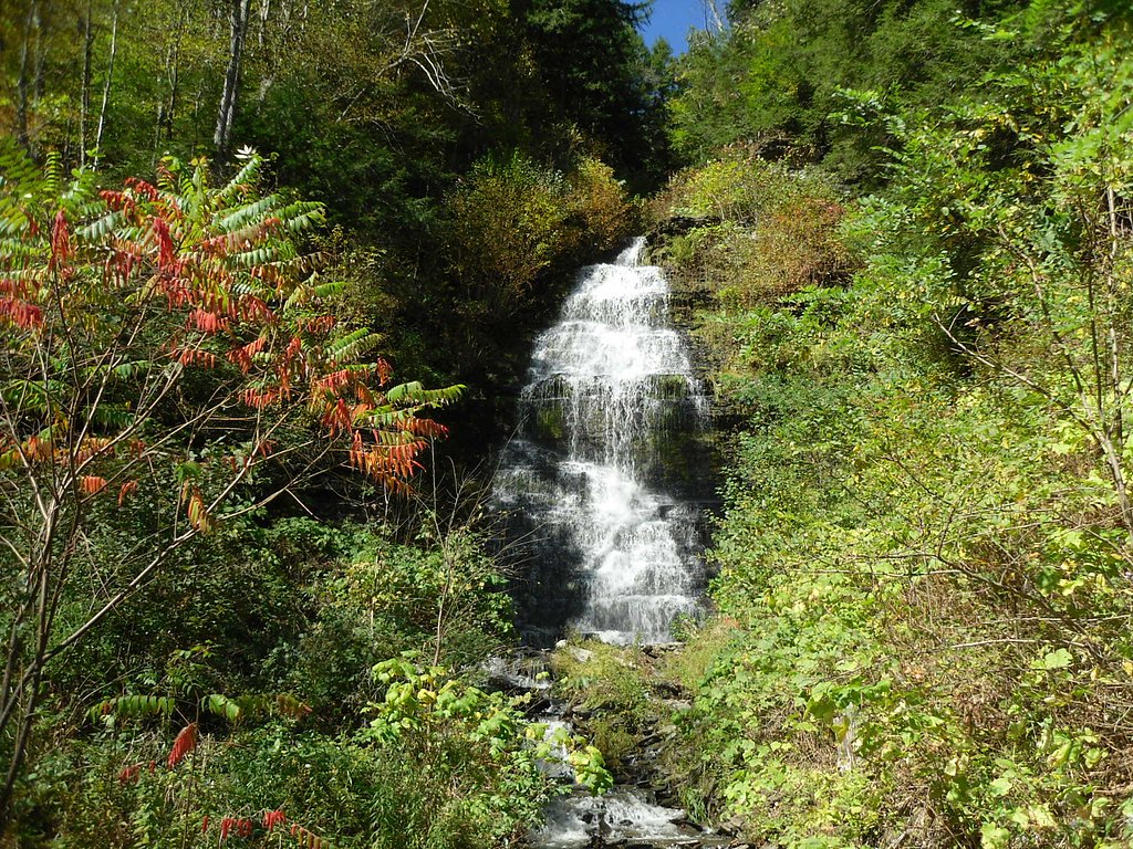
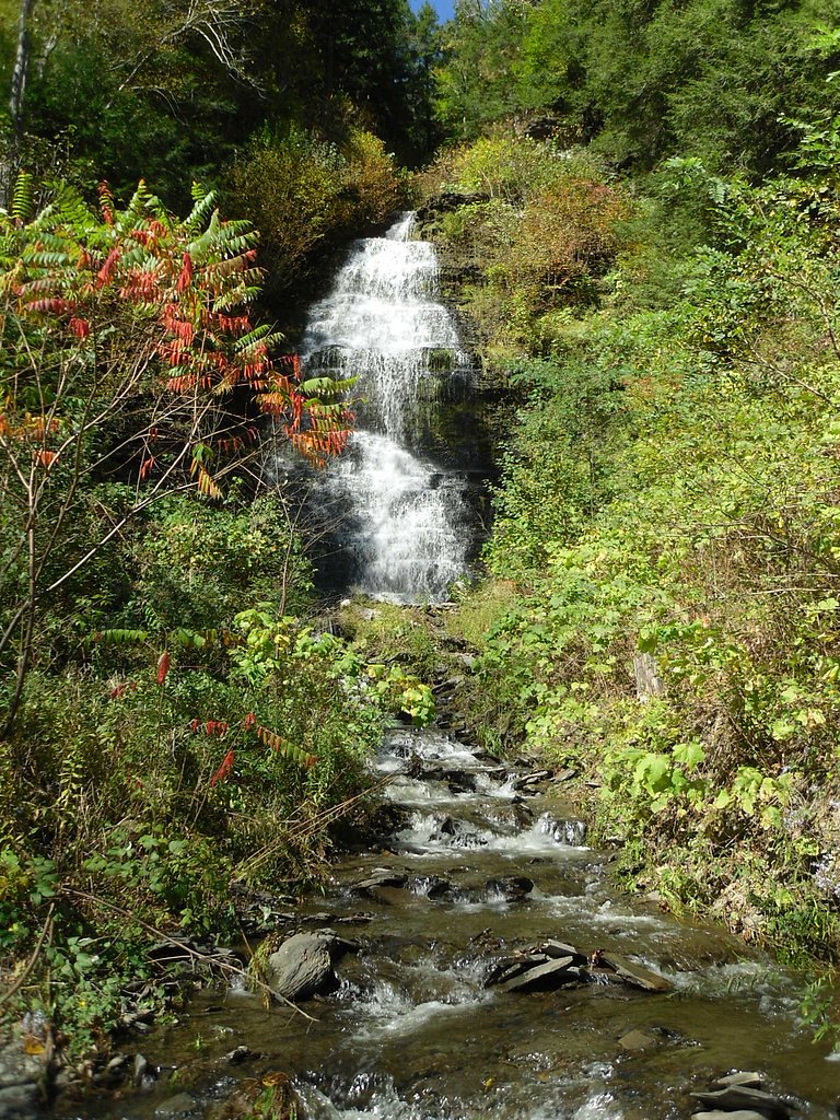
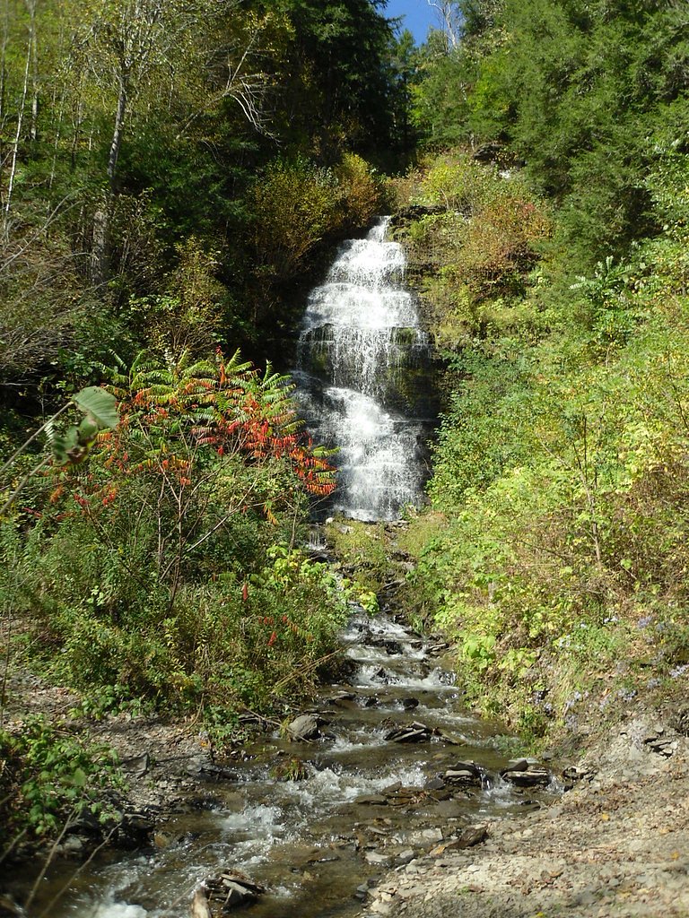
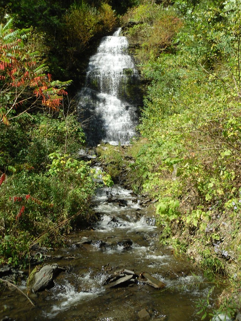
Photo Credits (5)
Difficulty
Moderate
Trail Length
1.5 miles
Trail Type
Out And Back
Elevation Gain
500 ft
About Buttermilk Falls
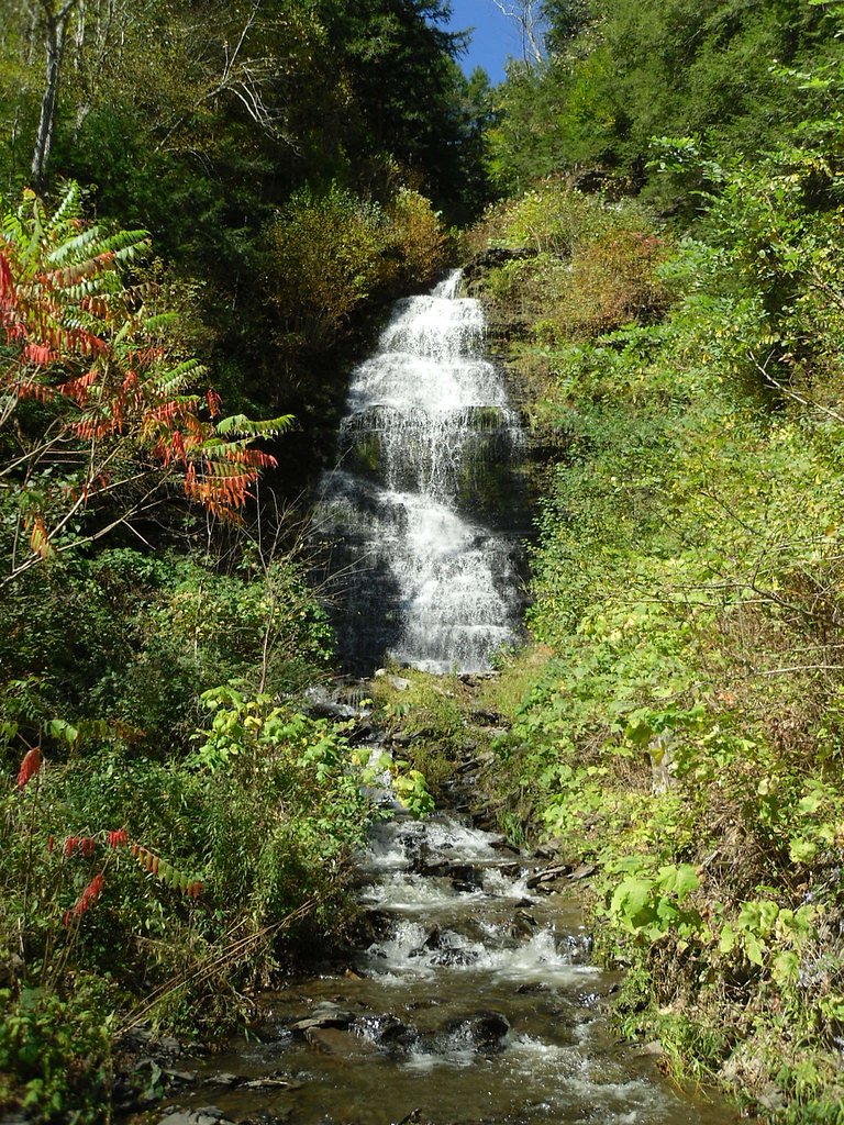
Tucked into Buttermilk Falls State Park just south of Ithaca, this Buttermilk Falls drops roughly 165 feet through a dramatic gorge, its frothy white cascades giving the falls their name. The site is one of the Finger Lakes region’s most photographed attractions, and — as Wikipedia notes — “Buttermilk Falls” is a name shared by several waterfalls; this particular waterfall is the signature feature of the state park and an easy destination for day visitors. The Gorge Trail threads along Buttermilk Creek to multiple overlooks of the main waterfall and smaller cascades, passing carved stone steps and sheltered pools. The hike is an out-and-back of about 1.5 miles with roughly 500 feet of cumulative elevation gain, rated moderate for its steep sections and uneven footing. For a longer loop, many visitors combine the Gorge Trail with the Rim Trail to return along the upper rim of the gorge within the state park.
The Setting
Buttermilk Falls sits at 604 feet along the Boquet River, in the foothills of New York. At 165 feet, it is among the taller waterfalls in New York.
Height: 165 feet
Trail & Hike Details
The Approach
The moderate 1.5-mile out-and-back trail gains 500 feet of elevation on the way to the falls.
Trail Description
Gorge Trail (out-and-back) — Length: ~1.5 miles round trip; Elevation gain: ~500 ft; Difficulty: Moderate. Surface and character: a mix of carved stone steps, packed dirt, and exposed roots with some short, steep pitches; footing can be uneven and slippery near water. The route follows the creek through the gorge to multiple viewpoints of the 165-foot main cascade; hikers looking for a loop can connect with the Rim Trail. Expect moderate grades on the descent/ascent and short stair-like sections rather than sustained technical climbing.
What to Expect
The falls plunge 165 feet. Swimming is permitted. Dogs are welcome.
Accessibility
The trail is not wheelchair accessible. Uneven terrain and elevation changes require steady footing.
Frequently Asked Questions
🐶 Are Dogs Allowed at Buttermilk Falls?
✅ Dogs are allowed
Are There Any Fees or Permits Required?
🤑 Fee: $9.00
🏊 Is There Swimming at Buttermilk Falls?
✅ Swimming is allowed
When to Visit
Spring and early summer are ideal for viewing the falls at their fullest flow, while fall offers stunning foliage. The trail may be icy in winter, so caution is advised.
Seasonal Access
The best time to visit is Spring, Summer, and Fall. Winter access may be limited.
Safety Information
The trail can be slippery, especially after rain. Stay on marked trails and avoid climbing on rocks near the falls. Swimming is only permitted in designated areas.
Current Water Conditions
218 ft³/s
Current discharge — how much water is flowing
About average for this time of year
Based on 81 years of record
2.79 ft
Water depth at gauge
7-Day Discharge Trend
What does this mean for your visit?
Flow is about average for this time of year.
About This Gauge
This gauge is on a nearby waterway and may not reflect exact conditions at the falls.
7-Day Flow Outlook
Based on the USGS gauge BOQUET RIVER AT WILLSBORO NY (12 km away).
Today
Low
218 cfs
6/10Tomorrow
Low
204 cfs
6/10Tue
Low
214 cfs
4/10Wed
Moderate
214 cfs
4/10Thu
Moderate
227 cfs
4/10Fri
Moderate
216 cfs
4/10Sat
Moderate
198 cfs
4/10Best window: Today — low flow, sunny (trip score 6/10).
Best time of year: this gauge typically runs highest from mid March to early June, peaking in April.
How we calculate this
This is a transparent outlook, not a precise forecast. We take the waterfall's current flow strength (how it ranks against its historical normal for today, from the nearest USGS stream gauge), carry that ranking forward along the gauge's seasonal curve, and nudge it for forecast rain. Confidence is highest for the next day or two and falls further out. Always check official conditions and your own judgment before visiting — high flows can be dangerous.
Know when to go.
Get a free email alert when waterfalls near Keeseville hit peak flow. We only send when conditions are worth the trip — no weekly newsletters, no spam.
Weather Forecast
Location & Access
Getting There
Buttermilk Falls is located in Buttermilk Falls State Park, just south of Ithaca, New York. The main entrance is off Route 13, and the falls are easily accessible from the parking area.
Get Directions on Google MapsParking
There is a designated parking area near the base of the falls, with ample space during most times of the year. Parking may fill up during peak seasons.
Elevation
604 feet above sea level
Coordinates
44.466160° N, -73.436800° W
Visitor Tips & Gear
Arrive early during weekends or peak seasons to secure parking. Wear sturdy footwear as the trail can be slippery, especially after rain. Bring water and be prepared for some steep sections.
As an Amazon Associate, we earn from qualifying purchases.
With 1.5 miles and 500 ft of elevation gain, sturdy boots and trekking poles will help on this moderate trail. Sun exposure on the trail makes good sun protection a must in summer.

Polarized Sunglasses (Knockaround)
Cuts glare off the water so you actually see the falls — and your photos turn out better too.

Columbia Watertight II Rain Jacket
Packs into its own pocket, seam-sealed, and keeps you dry from spray and surprise rain.

Earth Pak Waterproof Dry Bag
Keeps your phone and gear dry when waterfall mist soaks everything else.

Waterproof Phone Pouch (AiRunTech)
Cheap insurance — take photos right next to the falls without killing your phone.

Timberland Euro Sprint Mid Waterproof
Trusted waterproof boot with premium leather and grippy rubber sole — reliable on rocky, wet trails.

TrailBuddy Trekking Poles
Lightweight aluminum, cork grips, and flip-locks that actually hold — a best-seller for good reason.
Where to Stay

Green Mountain Suites Hotel

Stunning South Hero Home on Lake Champlain w/ View

Fairfield Inn by Marriott Burlington Williston

Hilton Garden Inn Burlington Downtown
Browse vacation cabins and private rentals nearby
Unique outdoor stays — tents, yurts, and treehouses
Rent a campervan or RV for your waterfall road trip
Some links are affiliate links. We may earn a commission at no extra cost to you.
Additional Information
Nearby Attractions
Other nearby attractions include Taughannock Falls State Park, Robert H. Treman State Park, and the city of Ithaca with its vibrant downtown and Cornell University.
Wildlife
The area is home to various bird species, deer, and small mammals. Visitors may also spot fish in the creek.
Cities near Buttermilk Falls
Nearby Waterfalls
 CC
CC
Other waterfalls named Buttermilk Falls
22 other waterfalls share this name across the U.S.
-
01
Apalachin
165 ftCurrent flow 73 ft³/s -
02
Claverack-Red Mills
165 ftCurrent flow 128 ft³/s -
03
Cohoes
165 ftCurrent flow 2,300 ft³/s -
04
East Worcester
165 ftCurrent flow 23 ft³/s -
05
Fultonville
165 ftCurrent flow 1,790 ft³/s -
06
Gloversville
165 ftCurrent flow 1,790 ft³/s -
07
Greenwood Lake
165 ftCurrent flow 45 ft³/s -
08
Highland Falls
Current flow 2 ft³/s -
09
Hudson Falls
165 ftCurrent flow 45 ft³/s -
10
Linwood
165 ftCurrent flow 94 ft³/s -
11
Palenville
165 ftCurrent flow 1 ft³/s -
12
Speculator
165 ftCurrent flow 260 ft³/s -
13
Wampsville
165 ftCurrent flow 44 ft³/s
Writing about Buttermilk Falls? Embed this waterfall on your site for free.