Photo Credits (1)
Difficulty
Easy
Trail Length
1.0 km
Trail Type
Out And Back
About Rainbow Falls
Rainbow Falls (coordinates: 52.3815, -119.9837) is a scenic waterfall in the interior of British Columbia. Public, detailed official information is limited; the feature appears to be in a forested, mountainous area typical of central BC and may be reached via secondary/forest-service roads. Expect a natural, undeveloped site with limited facilities and viewpoints formed by rugged terrain and steep banks. Specifics such as official name usage, exact fall height, and management agency are uncertain and may vary by map source.
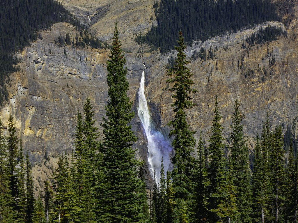
The Setting
Rainbow Falls sits at 718 metres within Wells Gray Park, in the hills of British Columbia. The falls drop 20 metres.
Why This Waterfall Exists
Rainbow Falls flows over layered sedimentary rock laid down about 252 million to 1.0 billion years ago. Over time, the stream has worn through these layers at different rates, creating a 65-foot drop that forms the waterfall.
Trail & Hike Details
Trail Description
Trail information is not well documented publicly. If a trail exists, it may be short but steep and unmaintained, involving loose rock, roots, and possible short scrambles to reach viewpoints. Expect an informal path or social trail rather than a constructed switchback trail. Navigation may require map/GPS and route-finding skills.
What to Expect
The falls drop 20 metres over layered sedimentary rock.
Accessibility
The trail is short and relatively flat, but the surface may be uneven. Contact the managing agency for accessibility details.
Frequently Asked Questions
🐶 Are Dogs Allowed at Rainbow Falls?
❌ Dogs are not allowed
Are There Any Fees or Permits Required?
🆖 No fees required
🏊 Is There Swimming at Rainbow Falls?
❌ Swimming is not allowed
When to Visit
Late spring to early summer for highest flows and dramatic appearance. Summer for easier road conditions and lower flows. Fall for foliage color and generally stable weather. Winter access may be difficult and icy, only attempt with proper winter gear and experience.
Seasonal Access
The best time to visit is Spring, Summer, and Fall. Winter access may be limited. Check with Wells Gray Park for current conditions.
Safety Information
Hazards include steep, unstable edges and cliffs, slippery wet or icy rock, fast-moving water, cold temperatures, sudden increases in flow (after rain or snowmelt), limited cell coverage, and seasonal road closures or poor road conditions. Do not approach the lip of the falls or stand on wet rocks. Travel with companions when possible, tell someone your route and expected return time, and carry emergency supplies. Check local advisories for wildlife activity, wildfire closures, or flood warnings before visiting.
Weather Forecast
Location & Access
Getting There
The waterfall is located at latitude 52.3815 and longitude -119.9837 in central British Columbia. Access is likely via secondary highways and logging/forest-service roads off a main route; road conditions may be rough and seasonally gated. There may be an unmarked trail or social path from a roadside pullout to a viewpoint. Confirm access and road status with local district offices, BC Parks (if within a park), or recent trip reports before you go.
Get Directions on Google MapsParking
Parking is likely informal (a roadside pullout or small gravel turnoff). Expect limited or no developed parking facilities. Park well off the road and avoid blocking gates or driveways.
Elevation
718 metres above sea level
Coordinates
52.381547° N, -119.983655° W
Land Management
Managed by Government of British Columbia
Visitor Tips & Gear
• Confirm current access and road conditions before traveling (forest service roads may be gated). • Wear sturdy, grippy footwear; expect uneven and slippery terrain. • Bring a map/GPS and download offline maps; cell coverage may be unreliable. • Carry bear spray and know how to use it; store food securely. • Keep a safe distance from cliff edges and fast water, wet rock is extremely slippery. • Leave no trace: pack out all trash and avoid disturbing vegetation. • Check local authorities for seasonal closures (wildfire, road washouts, or flood advisories).
Where to Stay
Browse vacation cabins and private rentals nearby
Unique outdoor stays — tents, yurts, and treehouses
Rent a campervan or RV for your waterfall road trip
Some links are affiliate links. We may earn a commission at no extra cost to you.
Nearby Campground
Rainbow Falls Campgrounf
0.5 km away
Additional Information
Nearby Attractions
This area of central BC contains multiple provincial parks, hiking areas, and notable waterfalls. Depending on exact access, nearby attractions may include other falls, forested trails, and scenic viewpoints, verify with regional maps or visitor centres for specific nearby sites.
Wildlife
Typical interior-BC wildlife may be present: black bears (and possibly grizzly in some areas), moose, deer, cougars, wolves, and smaller mammals. Birds of prey and waterfowl may also be seen. Be bear-aware and follow local guidelines for food storage and encounter avoidance.
Nearby Waterfalls
Other waterfalls named Rainbow Falls
31 other waterfalls share this name across Canada.
Writing about Rainbow Falls? Embed this waterfall on your site for free.