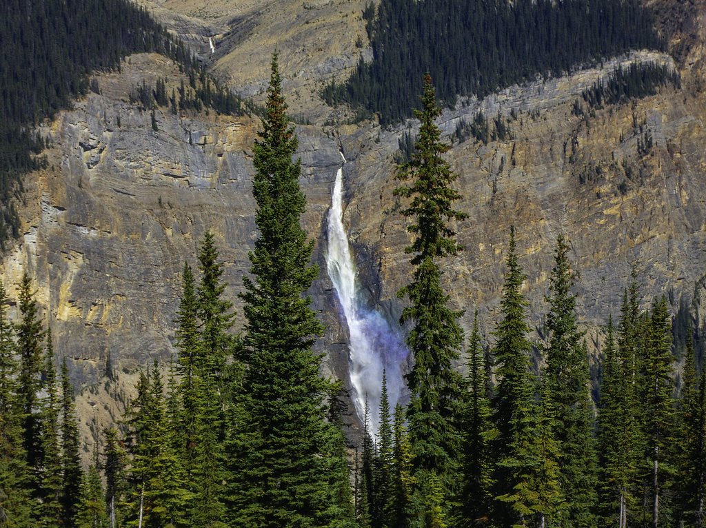
About Garnet Falls
Garnet Falls is a remote waterfall in the central interior of British Columbia (approx. coords 52.3665, -120.1833). Available reports indicate it is in a relatively undeveloped, forested area accessed by secondary roads and rough trails. Flow and accessibility are seasonal: highest flows are typically in spring and early summer from snowmelt, while late summer and fall can be lower. Specifics about the waterfall's height and formal infrastructure (lookouts, railings, signage) are not well-documented and appear to be minimal or non-existent.
The Setting
Garnet Falls sits at 729 metres within Wells Gray Park, in the hills of British Columbia.
Why This Waterfall Exists
Garnet Falls flows over layered sedimentary rock laid down about 252 million to 1.0 billion years ago. Over time, the stream has worn through these layers at different rates, creating the step that forms the waterfall.
Nearby Falls Worth Visiting
Rainbow Falls (20 m) lies 13.7 kilometres to the east. Also nearby: Lifely Falls (10 m, 7.2 km).
Trail & Hike Details
Trail Description
There does not appear to be a maintained, signed trail to Garnet Falls. Expect a rough approach that may include walking on old logging roads, cross-country travel through forest, stream crossings, and a possible short scramble to view the falls. Trail surface is likely uneven with roots, rocks, and muddy sections in wet seasons. Route-finding skills and a topographic map or GPS track from a recent trip report are strongly recommended.
What to Expect
Remote, forested terrain with limited or no facilities. Variable water flow depending on season, high in spring/early summer, lower in late summer/fall. No formal viewpoints or safety infrastructure are known; viewing may require descending to creek level or standing on slippery rock ledges. Insects (mosquitoes, black flies) can be abundant in warm months. Vehicle access may be restricted by seasonal gates or washouts on resource roads.
Accessibility
No wheelchair or stroller accessibility is known. Terrain is likely uneven, steep in places, and without constructed paths or railings, not accessible for people with limited mobility.
Frequently Asked Questions
🐶 Are Dogs Allowed at Garnet Falls?
❌ Dogs are not allowed
Are There Any Fees or Permits Required?
🆖 No fees required
🏊 Is There Swimming at Garnet Falls?
❌ Swimming is not allowed
When to Visit
Spring through early summer for the strongest flows and best waterfall display. Late summer and fall can offer lower flows and clearer access but reduced water volume. Winter access may be difficult or unsafe due to snow, ice, and frozen falls; ice conditions can be hazardous.
Seasonal Access
The best time to visit is Spring, Summer, Fall, and Winter. Check with Wells Gray Park for current conditions.
Safety Information
Hazards may include: slippery rocks and steep, unstable banks near the falls; strong currents and undertows near plunge pools; rapidly changing water flow after rain or snowmelt; exposure to weather and limited shelter; limited or no cell coverage and remote access making rescue slower; potential for encountering wildlife (bears, cougars); unstable or gated logging roads. Take conservative precautions: do not approach cliff edges, wear appropriate footwear, avoid getting too close to fast water, carry communication devices, and travel with others where possible.
Weather Forecast
Location & Access
Getting There
The waterfall is in a remote part of central British Columbia. Access likely requires travel on logging or resource roads and a short to moderate unmaintained trail or scramble to reach the creek and falls. A high-clearance vehicle or 4x4 may be needed to reach the nearest trailhead; some sections may be seasonal or gated. Visitors should consult recent local trip reports, regional forest service maps, or local recreation resources before traveling.
Get Directions on Google MapsParking
No formal parking lot is known. Parking is likely a roadside pullout or informal clearing near a logging road or trailhead. Be respectful of private gates and posted closures. Park completely off the road to avoid blocking access.
Elevation
729 metres above sea level
Coordinates
52.366538° N, -120.183257° W
Land Management
Managed by Government of British Columbia
Visitor Tips & Gear
- Check recent trip reports, local forest service or recreation pages, and maps before traveling. - Use a high-clearance vehicle if you plan to drive logging roads; be prepared for washboard, mud, or gates. - Tell someone your plans and expected return time; cell coverage may be limited or absent. - Wear sturdy footwear with good traction; wet rocks and steep banks are hazardous. - Bring insect repellent in spring/summer and warm layers in shoulder seasons. - Respect posted private property and resource road closures; obtain permission if crossing private land.
Where to Stay
Browse vacation cabins and private rentals nearby
Unique outdoor stays — tents, yurts, and treehouses
Rent a campervan or RV for your waterfall road trip
Some links are affiliate links. We may earn a commission at no extra cost to you.
Nearby Campground
Four and a Half Mile Campground
1.7 km away
Additional Information
Nearby Attractions
The location is in BC's central interior where visitors may find lakes, backcountry trails, and provincial parks regionally. Exact nearby named attractions are not confirmed for this specific coordinate, consult local maps or recreation guides for nearby parks, lakes, or viewpoints.
Wildlife
Typical central-B.C. wildlife may include black bears (and in some areas grizzly bears), moose, deer, coyotes/wolves, cougars, and a variety of birds and small mammals. Insect season can include mosquitoes and black flies. Use appropriate wildlife-safety practices and be prepared for encounters.
Nearby Waterfalls
Writing about Garnet Falls? Embed this waterfall on your site for free.