About Roostertail Falls
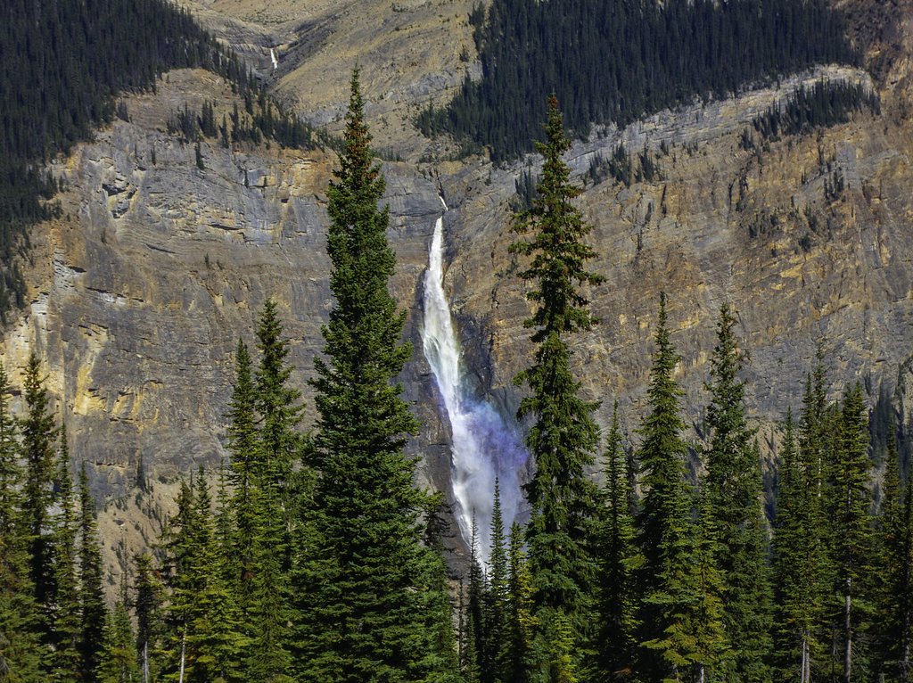
Roostertail Falls is a forested mountain waterfall in central British Columbia (coordinates 52.3558, -120.1856). It is reported to be a multi-step/cascading fall set in mixed coniferous forest and likely on a smaller tributary creek. Precise published measurements and formal facility information appear limited; descriptions below use conservative language where specifics are not verifiable.
The Setting
Roostertail Falls sits at 719 metres within Wells Gray Park, in the hills of British Columbia.
Why This Waterfall Exists
Roostertail Falls flows over layered sedimentary rock laid down about 252 million to 1.0 billion years ago. Over time, the stream has worn through these layers at different rates, creating the step that forms the waterfall.
Nearby Falls Worth Visiting
Rainbow Falls (20 m) lies 14.0 kilometres to the east. Also nearby: Lifely Falls (10 m, 6.1 km).
Trail & Hike Details
Trail Description
Detailed, authoritative trail descriptions are not readily available. Visitor reports suggest the approach may follow an unmarked or lightly marked forest track and short footpath through mixed forest to the creek. Expect uneven, possibly overgrown sections and limited trail maintenance. The final approach to the falls may require negotiating steep or slippery ground and rock outcrops; route-finding skills may be needed.
What to Expect
Expect a forested environment, variable water flow depending on season (highest in spring/snowmelt), rocky footing, and limited signage or facilities. Creek crossings, muddy sections, and blowdown or vegetation may be present. Cell coverage is likely unreliable in remote areas. Wildlife (including bears and ungulates) may be present.
Accessibility
The site is likely not wheelchair accessible. Trails are expected to be uneven, with roots, rocks, and possibly steep sections; not suitable for strollers.
Frequently Asked Questions
🐶 Are Dogs Allowed at Roostertail Falls?
❌ Dogs are not allowed
Are There Any Fees or Permits Required?
🆖 No fees required
🏊 Is There Swimming at Roostertail Falls?
❌ Swimming is not allowed
When to Visit
Late spring to early summer for highest flows (snowmelt). Summer provides easier road and trail access but lower flows in late summer may reduce the waterfall's impressiveness. Fall can offer fall color and fewer bugs but check road conditions. Winter access is likely difficult or unsafe without winter equipment and carries increased hazards from ice and snow.
Seasonal Access
The best time to visit is Spring, Summer, and Fall. Winter access may be limited. Check with Wells Gray Park for current conditions.
Safety Information
Hazards can include slippery and unstable rocks, steep drop-offs near the falls, fast water flows during high runoff, cold water temperatures, limited cell reception, and wildlife encounters. Do not climb on wet rocks near the edge. Always maintain a safe distance from cliff edges and fast-moving water. Check weather and road conditions before traveling. If forestry roads are used to access the area, they may be seasonally closed or subject to logging activity, obey gates and signage.
Weather Forecast
Location & Access
Getting There
The falls are in a remote, forested area of central BC. Access typically requires driving on secondary or forestry roads and then a hike on an unpaved trail or informal route. A high-clearance vehicle may be helpful to reach pullouts on logging or gravel roads. Expect limited or no signage from major highways; consult local land/park maps or local recreation resources before travel.
Get Directions on Google MapsParking
Parking is likely limited to a small pullout or informal roadside area near the trail start. There do not appear to be developed parking lots, restrooms, or visitor services at the immediate site. Park responsibly off the road and avoid blocking gates.
Elevation
719 metres above sea level
Coordinates
52.355805° N, -120.185553° W
Land Management
Managed by Government of British Columbia
Visitor Tips & Gear
1) Check up-to-date local conditions with regional park/forest offices or local recreation resources before you go. 2) Use a high-clearance vehicle for forestry roads and park legally. 3) Wear sturdy, waterproof footwear and be prepared for slippery rocks. 4) Travel with a partner, leave an itinerary with someone, and carry a map/GPS. 5) Bring insect repellent in summer and bear spray in bear country. 6) Practice Leave No Trace and avoid fragile streamside vegetation.
Where to Stay
Browse vacation cabins and private rentals nearby
Unique outdoor stays — tents, yurts, and treehouses
Rent a campervan or RV for your waterfall road trip
Some links are affiliate links. We may earn a commission at no extra cost to you.
Nearby Campground
Osprey Campground
1.8 km away
Additional Information
Nearby Attractions
This area of central BC contains numerous provincial parks, lakes, and other natural features. Check regional maps for nearby destinations such as provincial parks, hiking trails, and lakes. Exact nearby named attractions relative to these coordinates should be confirmed with a local map.
Wildlife
Black bears, deer, moose, small mammals, and a variety of bird species may inhabit the area. Insect activity (mosquitoes, black flies) can be heavy in summer. Take standard wildlife precautions.
Nearby Waterfalls
Writing about Roostertail Falls? Embed this waterfall on your site for free.