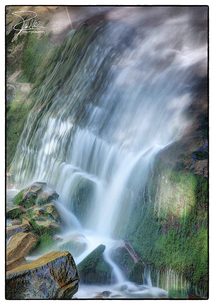
Rainbow Falls
Tennessee • 80 ft
By Armen Suny · Last verified Mar 2026
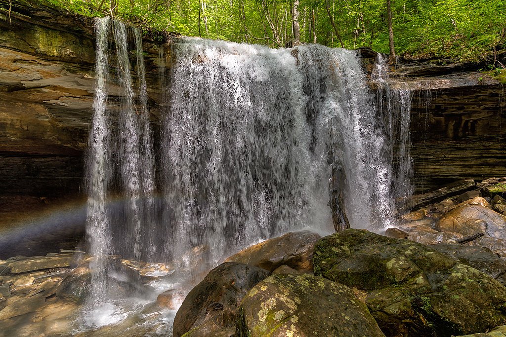
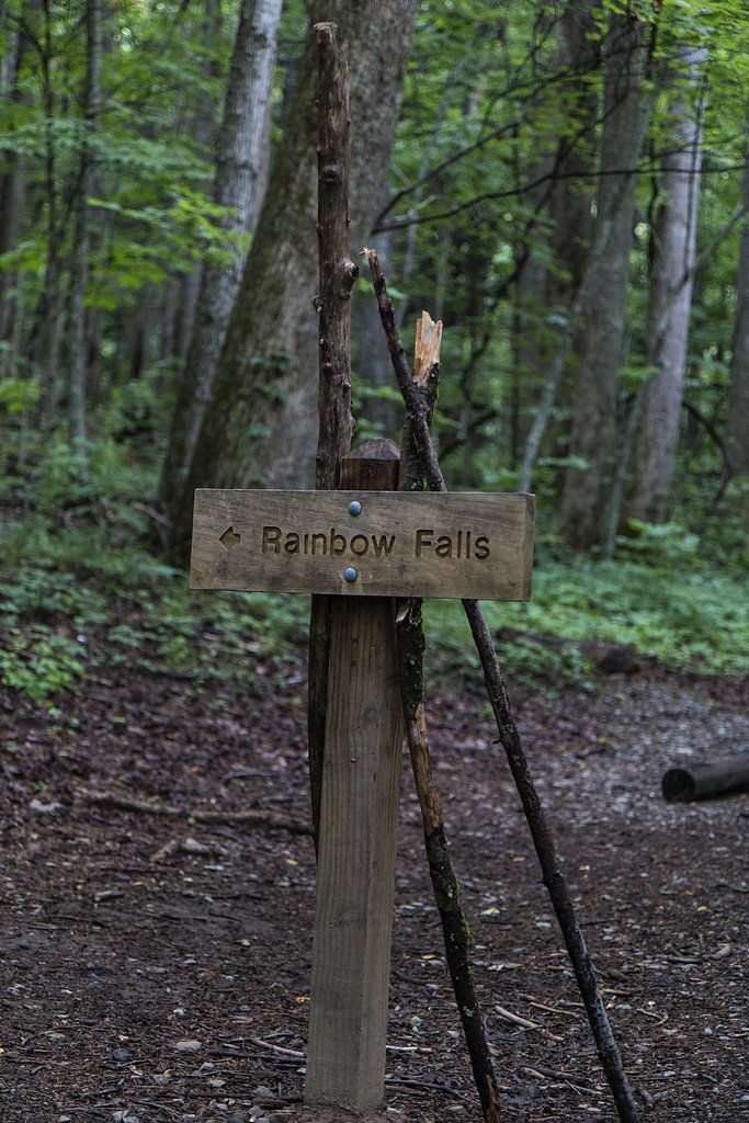
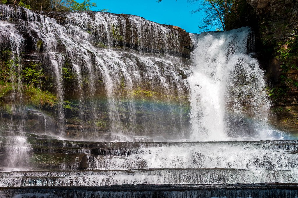
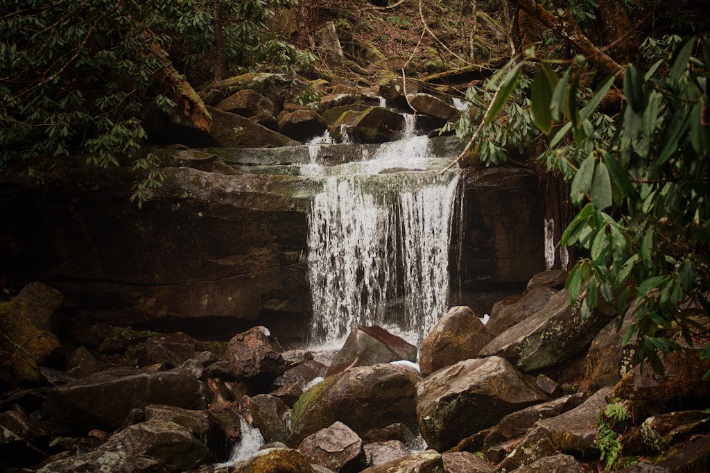
Photo Credits (5)
Difficulty
Moderate
Trail Length
2.4 miles
Trail Type
Out And Back
Elevation Gain
350 ft
About Rainbow Falls
Rainbow Falls is a striking 80-foot cascade in Tennessee, tucked into the Dry Creek Wildlife Management Area. The falls earn their name on sunny days when mist catches the light and produces frequent rainbows. The site sits within a designated SCA land unit and is managed by SFW; the parcel is noted as privately owned (PVT), so visitors should be respectful of posted rules and access guidelines. The setting is a lovely mix of forest and creekside rock, making Rainbow Falls a rewarding destination for hikers and photographers. The approach is moderate and approachable for most fit day-hikers: the out-and-back route covers a compact distance with enough elevation change to feel like a true mountain stroll without committing to a long backcountry trip.
The Setting
Rainbow Falls sits at 518 feet within Dry Creek Wildlife Management Area, fed by the Horse Creek, in the foothills of Tennessee. The falls drop 80 feet.
Height: 80 feet
Trail & Hike Details
The Approach
The moderate 2.4-mile out-and-back trail gains 350 feet of elevation on the way to the falls.
Trail Description
Trail length: 2.4 miles round-trip (out-and-back). Elevation gain: approximately 350 feet. Difficulty: moderate. The Rainbow Falls Trail climbs steadily to the waterfall, with a moderate grade over the route. Expect a rocky, uneven surface with roots and natural tread—comfortable, sturdy footwear is recommended. The short but steady ascent makes this a good half-day hike; the trail is not listed with a USFS trail number in the provided data, so check local signage and the Dry Creek Wildlife Management Area guidance (managed by SFW) before you go.
What to Expect
The falls cascade 80 feet.
Accessibility
The trail is not wheelchair accessible. Uneven terrain and elevation changes require steady footing.
Frequently Asked Questions
🐶 Are Dogs Allowed at Rainbow Falls?
❌ Dogs are not allowed
Are There Any Fees or Permits Required?
🤑 Fee: $5.00
🏊 Is There Swimming at Rainbow Falls?
❌ Swimming is not allowed
When to Visit
The best time to visit is in the spring or after rainfall when the waterfall is at its fullest. Fall offers beautiful foliage, while summer provides lush greenery. Winter visits may feature icy formations but can be more challenging due to trail conditions.
Seasonal Access
The best time to visit is Spring, Summer, and Fall. Winter access may be limited.
Safety Information
The trail can be slippery, especially after rain. Watch for loose rocks and roots. Carry bear spray and be aware of wildlife. Check weather conditions before your hike.
Current Water Conditions
88 ft³/s
Current discharge — how much water is flowing
About average for this time of year
Based on 13 years of record
0.87 ft
Water depth at gauge
7-Day Discharge Trend
What does this mean for your visit?
Flow is about average for this time of year.
About This Gauge
This gauge is on a nearby waterway and may not reflect exact conditions at the falls.
7-Day Flow Outlook
Based on the USGS gauge HORSE CREEK NEAR SAVANNAH, TN (TVA) (18 km away).
Today
Low
101 cfs
3/10Tomorrow
Low
107 cfs
3/10Fri
Low
104 cfs
3/10Sat
Low
99 cfs
3/10Sun
Low
116 cfs
3/10Mon
Low
124 cfs
3/10Tue
Low
115 cfs
3/10Best window: Today — low flow, sunny then slight chance showers and thunderstorms (trip score 3/10).
Best time of year: this gauge typically runs highest from early February to late April, peaking in February.
How we calculate this
This is a transparent outlook, not a precise forecast. We take the waterfall's current flow strength (how it ranks against its historical normal for today, from the nearest USGS stream gauge), carry that ranking forward along the gauge's seasonal curve, and nudge it for forecast rain. Confidence is highest for the next day or two and falls further out. Always check official conditions and your own judgment before visiting — high flows can be dangerous.
Know when to go.
Get a free email alert when waterfalls near Counce hit peak flow. We only send when conditions are worth the trip — no weekly newsletters, no spam.
Weather Forecast
Location & Access
Getting There
Rainbow Falls is accessed via the Rainbow Falls Trail, which begins at the Rainbow Falls Trailhead located off Cherokee Orchard Road near Gatlinburg, Tennessee.
Get Directions on Google MapsParking
Parking is available at the Rainbow Falls Trailhead, but it can fill up quickly, especially during peak seasons. Arrive early to secure a spot.
Elevation
518 feet above sea level
Coordinates
35.031809° N, -88.132029° W
Land Management
Managed by SFW
Visitor Tips & Gear
Start early to avoid crowds and ensure you have enough daylight for the hike. Wear sturdy hiking shoes, as the trail can be rocky and slippery in places. Bring plenty of water and snacks.
As an Amazon Associate, we earn from qualifying purchases.
With 2.4 miles and 350 ft of elevation gain, sturdy boots and trekking poles will help on this moderate trail. Sun exposure on the trail makes good sun protection a must in summer.

Polarized Sunglasses (Knockaround)
Cuts glare off the water so you actually see the falls — and your photos turn out better too.

Columbia Watertight II Rain Jacket
Packs into its own pocket, seam-sealed, and keeps you dry from spray and surprise rain.

Earth Pak Waterproof Dry Bag
Keeps your phone and gear dry when waterfall mist soaks everything else.

Waterproof Phone Pouch (AiRunTech)
Cheap insurance — take photos right next to the falls without killing your phone.

Timberland Euro Sprint Mid Waterproof
Trusted waterproof boot with premium leather and grippy rubber sole — reliable on rocky, wet trails.

TrailBuddy Trekking Poles
Lightweight aluminum, cork grips, and flip-locks that actually hold — a best-seller for good reason.
Where to Stay

Eagle's Bluff Cabin

Hampton Inn Corinth

Pickwick Dreams

Hampton Inn Pickwick Dam-At Shiloh Falls
Browse vacation cabins and private rentals nearby
Unique outdoor stays — tents, yurts, and treehouses
Rent a campervan or RV for your waterfall road trip
Some links are affiliate links. We may earn a commission at no extra cost to you.
Additional Information
Nearby Attractions
Nearby attractions include Gatlinburg, the Alum Cave Trail, and Clingmans Dome.
Wildlife
The area is home to black bears, deer, and a variety of bird species. Always maintain a safe distance from wildlife.
Cities near Rainbow Falls
Other waterfalls named Rainbow Falls
31 other waterfalls share this name across the U.S.
Writing about Rainbow Falls? Embed this waterfall on your site for free.