About Sarlacc's Pit
"Sarlacc's Pit" at the provided coordinates (52.5164, -120.0432) does not appear to be an officially named or well-documented waterfall in provincial or federal park databases. The name is likely informal or local. The feature at these coordinates is in the remote interior of British Columbia and may be a steep-sided pit, gorge, sinkhole, small cascade, or other geomorphic feature rather than a developed or signed waterfall site. Official trail and management information is not readily available; treat references to this site as unvalidated and potentially on unmaintained or private lands.
The Setting
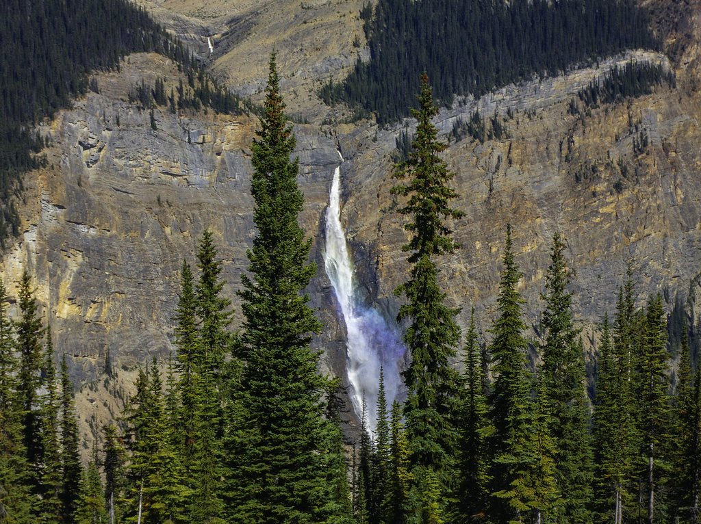
Sarlacc's Pit sits at 1,732 metres within Wells Gray Park, in the high mountains of British Columbia.
Why This Waterfall Exists
Sarlacc's Pit flows over layered sedimentary rock laid down about 252 million to 1.0 billion years ago. Over time, the stream has worn through these layers at different rates, creating the step that forms the waterfall.
Nearby Falls Worth Visiting
Rainbow Falls (20 m) lies 15.6 kilometres to the southeast.
Trail & Hike Details
Trail Description
There is no verified, maintained trail description available from official park or popular hiking resources for this feature. If an access route exists it may be an unmaintained scramble or cross-country approach over steep, brushy, or rocky terrain. Expect no signage, no built switchbacks, and potentially difficult footing near the feature.
What to Expect
Expect a remote natural feature with little or no visitor infrastructure. Terrain in interior BC can include dense forest, muskeg, talus or rocky bluffs and seasonal streams. Cell service is likely unreliable. Weather can change quickly and roads or approaches may be seasonally gated or impassable. If the feature is a pit or steep-sided gorge, edges may be unstable.
Accessibility
Access is likely not accessible to people with mobility impairments. Expect rough, uneven, and possibly steep terrain with no built infrastructure.
Frequently Asked Questions
🐶 Are Dogs Allowed at Sarlacc's Pit?
❌ Dogs are not allowed
Are There Any Fees or Permits Required?
🆖 No fees required
🏊 Is There Swimming at Sarlacc's Pit?
❌ Swimming is not allowed
When to Visit
Summer and early fall typically provide the most reliable and accessible conditions for remote interior-BC features due to reduced snow and improved road conditions. Spring may have higher water flows but also muddy or flooded approaches. Winter access may be hazardous or impossible without specialized equipment (snowmobile, skis) and carries avalanche/ice hazards.
Seasonal Access
The best time to visit is Spring, Summer, Fall, and Winter. Check with Wells Gray Park for current conditions.
Safety Information
Hazards may include steep and unstable edges, loose rock, deep or hidden holes, slippery surfaces, sudden drops, poor or no cell coverage, rapidly changing weather, and wildlife encounters including bears. Forestry roads may be rough, gated, or seasonally closed. Do not rely on there being signage, railings, or rescue services nearby. If uncertain about conditions, do not attempt approaches that require technical climbing or crossing unstable ground. Always check local land management offices for current warnings and closures.
Weather Forecast
Location & Access
Getting There
Coordinates place the feature in remote interior British Columbia. Access is likely by secondary or resource (forestry) roads and/or cross-country travel. There is no well-documented public trailhead or official access route in major guide resources. Use detailed topographic maps, satellite imagery, and local land management (Provincial Ministry of Forests, local district office) resources to confirm access before traveling.
Get Directions on Google MapsParking
No confirmed formal parking area. If reachable by road, parking may be an informal roadside pullout on a forestry road. Do not block gates or roads; respect private property and posted closures.
Elevation
1,732 metres above sea level
Coordinates
52.516431° N, -120.043178° W
Land Management
Managed by Government of British Columbia
Visitor Tips & Gear
• Confirm land status and access before visiting (Crown land vs. private land vs. managed forestry area). • Use a reliable map (topo or satellite) and GPS with the provided coordinates. Bring a paper map and compass as backup. • Travel with someone, tell someone your plan and expected return time. • Wear sturdy footwear and bring rain/wind layers; terrain may be steep and slippery. • Avoid going to cliff edges; loose rock and vegetation can give way. • Be prepared for no services: carry extra water, food, first aid, and emergency supplies. • If you encounter logging roads, follow closures and signage and yield to industrial traffic.
This trail sits at 5,682 ft above sea level
Elevated TrailUV radiation is roughly 23% stronger at this elevation than at sea level, and the dry air accelerates dehydration. Extra sun protection and fluids go a long way.
As an Amazon Associate, we earn from qualifying purchases.

Coppertone Sport SPF 50 Sunscreen
UV intensity jumps ~4% per 1,000 ft — at this elevation you can burn in half the time.

Sun Bum SPF 30 Lip Balm (3-Pack)
Lips have almost no natural UV protection and burn fast in thin, dry mountain air.

Liquid I.V. Electrolyte Packets
You lose moisture ~2x faster at elevation — electrolytes help you absorb water efficiently.

ROCKNIGHT Polarized UV400 Sunglasses
High-altitude glare off rock and water is intense — UV400 lenses block 99%+ of UVA/UVB.
Where to Stay
Browse vacation cabins and private rentals nearby
Unique outdoor stays — tents, yurts, and treehouses
Rent a campervan or RV for your waterfall road trip
Some links are affiliate links. We may earn a commission at no extra cost to you.
Nearby Campground
Rainbow Falls Campgrounf
15.9 km away
Additional Information
Nearby Attractions
No officially documented nearby attractions are confirmed for this exact coordinate in major publicly available recreation resources. The location is in remote interior BC; larger provincial parks, lakes, or known recreation areas may be many kilometers away. Consult regional maps to identify the nearest named parks or towns prior to travel.
Wildlife
Typical interior British Columbia wildlife may be present: black bears (and possibly grizzly bears depending on exact location), moose, deer, wolves, cougars, and small mammals and birds. Be bear-aware and store food appropriately.
Nearby Waterfalls
Writing about Sarlacc's Pit? Embed this waterfall on your site for free.