Photo Credits (1)
Difficulty
Easy
Trail Length
0.6 km
Trail Type
Out And Back
About Rainbow Falls
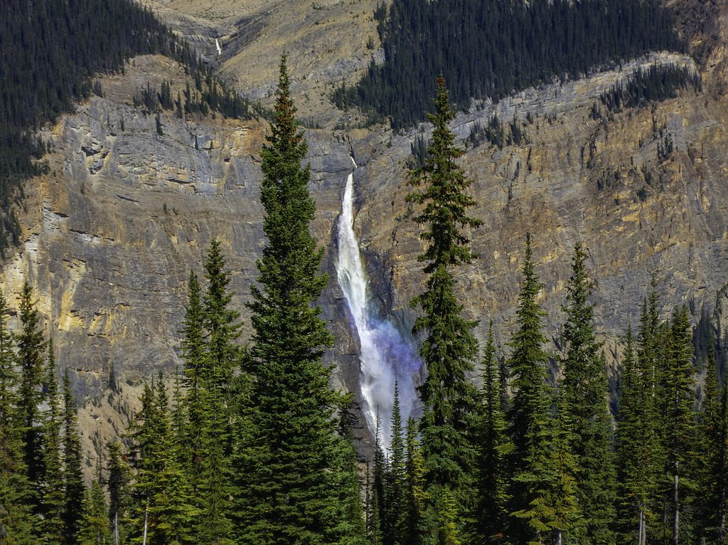
Rainbow Falls (coordinates 50.4851, -118.4454) is a scenic interior British Columbia waterfall located in the general Revelstoke / Upper Arrow Lake region. The falls commonly produce spray and prism-like rainbows in sunny conditions (hence the name). Specific published trail and height data are limited; the site is relatively remote and access may be via secondary/forestry roads and a short hiking approach. Expect natural, undeveloped viewing areas rather than formal viewing platforms.
The Setting
Rainbow Falls sits at 690 metres within MONASHEE PARK, in the hills of British Columbia.
Why This Waterfall Exists
Rainbow Falls flows over hard intrusive rock, primarily granite, laid down about 23-66 million years ago. These resistant rocks form a durable ledge that water cannot easily wear away, creating the falls where softer material downstream has already eroded.
Trail & Hike Details
Trail Description
Trail and approach information for this specific Rainbow Falls location is not consistently documented. Many visitors report a short, unmaintained trail or scramble from a roadside pullout to reach viewpoints. Surfaces may be uneven, rocky, and steep in places. Trails may be unsigned and can become muddy or brushy after rain or during spring melt. Because of limited official infrastructure, route-finding and basic backcountry navigation skills may be useful.
What to Expect
A natural, scenic waterfall with spray that often produces visible rainbows on sunny days. Expect limited trail infrastructure, natural viewpoints, and potentially wet, slippery rocks near the water. Flow is seasonal, typically higher in spring and early summer from snowmelt, lower in late summer and fall. Cell service may be limited in parts of the approach. There are few or no facilities on site.
Accessibility
The trail is short and relatively flat, but the surface may be uneven. Contact the managing agency for accessibility details.
Frequently Asked Questions
🐶 Are Dogs Allowed at Rainbow Falls?
❌ Dogs are not allowed
Are There Any Fees or Permits Required?
🆖 No fees required
🏊 Is There Swimming at Rainbow Falls?
❌ Swimming is not allowed
When to Visit
Late spring to early summer for the fullest flows and the most dramatic appearance; early morning or late afternoon for softer light and to increase chances of seeing rainbows in the spray. Avoid high water or storm conditions.
Seasonal Access
The best time to visit is Spring, Summer, and Fall. Winter access may be limited. Check with the managing park or local authority for current conditions.
Safety Information
Hazards include slippery rocks and steep, unstable banks near the falls; high spring flow and strong currents; cold water temperatures; limited or no cell service in parts of the approach; rough or seasonally gated access roads; wildlife encounters (bears). Use caution, avoid getting too close to edges, do not climb on wet rocks, and check current conditions before visiting. Inform someone of your plans if venturing into remote areas.
Current Water Conditions
44.2 m³/s
Current discharge — how much water is flowing
About average for this time of year
Based on 60 years of record
2.28 m
Water depth at gauge
7-Day Discharge Trend
What does this mean for your visit?
Flow is about average for this time of year.
About This Gauge
This gauge is on a nearby waterway and may not reflect exact conditions at the falls.
7-Day Flow Outlook
Based on the WSC gauge SHUSWAP RIVER AT OUTLET OF SUGAR LAKE RESERVOIR (17 km away).
Today
Moderate
44 m³/s
8/10Tomorrow
Moderate
41 m³/s
6/10Tue
Moderate
41 m³/s
6/10Wed
Moderate
38 m³/s
6/10Thu
Moderate
37 m³/s
5/10Fri
Moderate
36 m³/s
6/10Sat
Moderate
34 m³/s
6/10Best window: Today — moderate flow, sunny (trip score 8/10).
Best time of year: this gauge typically runs highest from late April to late July, peaking in June.
How we calculate this
This is a transparent outlook, not a precise forecast. We take the waterfall's current flow strength (how it ranks against its historical normal for today, from the nearest WSC stream gauge), carry that ranking forward along the gauge's seasonal curve, and nudge it for forecast rain. Confidence is highest for the next day or two and falls further out. Always check official conditions and your own judgment before visiting — high flows can be dangerous.
Know when to go.
Get a free email alert when waterfalls near Revelstoke hit peak flow. We only send when conditions are worth the trip — no weekly newsletters, no spam.
Weather Forecast
Location & Access
Getting There
Located roughly 36 miles (58 km) from Revelstoke and about 72.5 miles (117 km) from Kelowna (coordinates 50.4851, -118.4454). Access typically requires driving on primary highway(s) in the region followed by secondary or forestry roads; these roads may be unpaved and seasonally gated. Final approach is likely a short walk from a roadside parking area or pullout. Check local BC provincial/forestry maps and recent trip reports before travel.
Get Directions on Google MapsParking
Parking is likely limited to a small roadside pullout or informal parking spot; expect no formal lot, vault toilets, or developed facilities. Park well off the travelled portion of any road and do not block gates.
Elevation
690 metres above sea level
Coordinates
50.485149° N, -118.445402° W
Land Management
Managed by Government of British Columbia
Visitor Tips & Gear
• Check recent trip reports, local forest service bulletins, or AllTrails-type listings for up-to-date access notes and road conditions before you go. • Use caution near cliff edges and wet rock; strong currents and undercut banks are possible. • Wear sturdy footwear with good traction; hiking poles are useful for uneven approaches. • Bring a map and know the access roads; forestry roads can be rough and sometimes gated seasonally. • Leave no trace: pack out all garbage and avoid trampling vegetation near the falls. • If travelling in bear country, carry bear spray and make noise while approaching. • If unsure about safety near the water, do not attempt to swim or climb near the falls.
Where to Stay
Browse vacation cabins and private rentals nearby
Unique outdoor stays — tents, yurts, and treehouses
Rent a campervan or RV for your waterfall road trip
Some links are affiliate links. We may earn a commission at no extra cost to you.
Nearby Campground
Kate Lake Recreation Site
4.4 km away
Additional Information
Nearby Attractions
Nearest larger communities: Revelstoke (≈36 miles) and Kelowna (≈72.5 miles). The broader region includes Mount Revelstoke National Park, Glacier National Park (BC), and numerous provincial recreation sites and hiking routes, all offering additional hiking and scenic opportunities. Verify exact distances and access if planning a multi-site trip.
Wildlife
Typical interior-British Columbia wildlife: black bears, deer, moose, cougars (rare), small mammals, and birds. Ticks and insects can be present in warmer months. Practice standard wildlife-safety precautions.
Cities near Rainbow Falls
Other waterfalls named Rainbow Falls
31 other waterfalls share this name across Canada.
Writing about Rainbow Falls? Embed this waterfall on your site for free.