Photo Credits (5)
Difficulty
Moderate
Trail Length
2.4 miles
Trail Type
Out And Back
Elevation Gain
350 ft
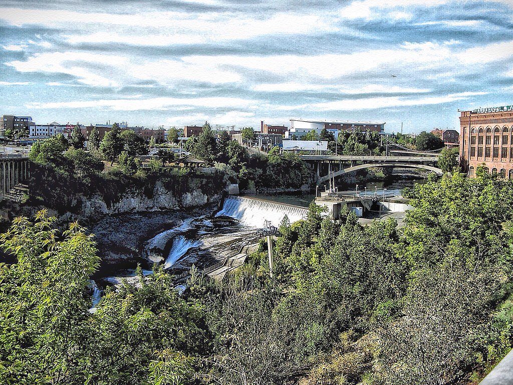
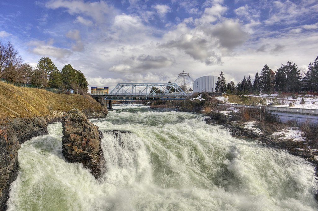
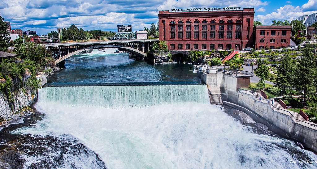
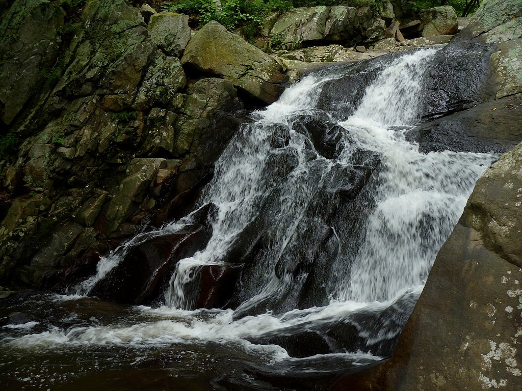
About Upper Falls
Upper Falls sits along the Spokane River in Washington and is one of the striking drops that make up the Spokane Falls area. The cascade is easily enjoyed from a series of viewing platforms and bridges that frame the river’s flow, making it a popular stop for photographers, families and anyone exploring the riverfront. The setting combines dramatic water views with accessible paths, so you don’t need technical gear to appreciate the scene. Access to Upper Falls is provided by a well-marked 2.4-mile out-and-back trail that climbs about 350 feet and is rated moderate, so plan for some steady uphill sections on the approach. If you’re planning to camp nearby, the closest facility is North Gorge Campground, roughly 23.9 km away, though many visitors treat Upper Falls as a day-hike or an easy stop on a longer Spokane-area outing.
The Setting
Upper Falls sits at 1,660 feet along the Columbia River, in the hills of Washington.
Trail & Hike Details
The Approach
The moderate 2.4-mile out-and-back trail gains 350 feet of elevation on the way to the falls.
Trail Description
This route to Upper Falls is a 2.4-mile out-and-back trail with approximately 350 feet of elevation gain and a moderate difficulty rating. The path is well-maintained and includes paved sections, bridges and viewing platforms that provide multiple vantage points of the falls and the Spokane River. The trail is suitable for most hikers comfortable with moderate climbs and offers relatively direct access to the primary viewpoints—expect a mix of paved walking surfaces and typical riverfront trail features rather than rugged backcountry conditions.
What to Expect
Dogs are welcome.
Accessibility
The trail is not wheelchair accessible. Uneven terrain and elevation changes require steady footing.
Frequently Asked Questions
🐶 Are Dogs Allowed at Upper Falls?
✅ Dogs are allowed
Are There Any Fees or Permits Required?
🆖 No fees required
🏊 Is There Swimming at Upper Falls?
❌ Swimming is not allowed
When to Visit
Spring and early summer are ideal times to visit when the water flow is at its peak due to snowmelt.
Seasonal Access
The best time to visit is Spring, Summer, and Fall. Winter access may be limited.
Safety Information
Stay on designated paths and viewing areas. The river can be fast-moving and dangerous, especially during high water flow.
Current Water Conditions
138,000 ft³/s
Current discharge — how much water is flowing
About average for this time of year
Based on 88 years of record
107.45 ft
Water depth at gauge
7-Day Discharge Trend
What does this mean for your visit?
Flow is about average for this time of year.
About This Gauge
This gauge is on a nearby waterway and may not reflect exact conditions at the falls.
7-Day Flow Outlook
Based on the USGS gauge COLUMBIA RIVER AT INTERNATIONAL BOUNDARY (13 km away).
Today
Moderate
157320 cfs
4/10Tomorrow
Moderate
157803 cfs
5/10Sat
Moderate
162840 cfs
6/10Sun
Moderate
170754 cfs
6/10Mon
Moderate
160493 cfs
5/10Tue
Moderate
163760 cfs
6/10Wed
Moderate
158700 cfs
5/10Best window: Sat — moderate flow, showers and thunderstorms (trip score 6/10).
Best time of year: this gauge typically runs highest from early May to early August, peaking in June.
How we calculate this
This is a transparent outlook, not a precise forecast. We take the waterfall's current flow strength (how it ranks against its historical normal for today, from the nearest USGS stream gauge), carry that ranking forward along the gauge's seasonal curve, and nudge it for forecast rain. Confidence is highest for the next day or two and falls further out. Always check official conditions and your own judgment before visiting — high flows can be dangerous.
Know when to go.
Get a free email alert when waterfalls near Northport hit peak flow. We only send when conditions are worth the trip — no weekly newsletters, no spam.
Weather Forecast
Location & Access
Getting There
Upper Falls is located in Spokane, Washington, near Riverfront Park. It can be accessed via walking paths in the park or by viewing platforms along the Spokane River.
Get Directions on Google MapsParking
Parking is available at Riverfront Park and nearby public lots. Fees may apply depending on the location and time of day.
Elevation
1,660 feet above sea level
Coordinates
48.954756° N, -117.798950° W
Visitor Tips & Gear
Visit early in the morning or on weekdays to avoid crowds. Bring a camera to capture the beauty of the falls and the surrounding park.
As an Amazon Associate, we earn from qualifying purchases.
With 2.4 miles and 350 ft of elevation gain, sturdy boots and trekking poles will help on this moderate trail. Sun exposure on the trail makes good sun protection a must in summer.

Polarized Sunglasses (Knockaround)
Cuts glare off the water so you actually see the falls — and your photos turn out better too.

Columbia Watertight II Rain Jacket
Packs into its own pocket, seam-sealed, and keeps you dry from spray and surprise rain.

Earth Pak Waterproof Dry Bag
Keeps your phone and gear dry when waterfall mist soaks everything else.

Waterproof Phone Pouch (AiRunTech)
Cheap insurance — take photos right next to the falls without killing your phone.

Timberland Euro Sprint Mid Waterproof
Trusted waterproof boot with premium leather and grippy rubber sole — reliable on rocky, wet trails.

TrailBuddy Trekking Poles
Lightweight aluminum, cork grips, and flip-locks that actually hold — a best-seller for good reason.
Where to Stay

The Josie Hotel, Autograph Collection

Sparkling NEW Rossland Midtown Studio Apartment

The Flying Steamshovel Inn

SureStay Hotel by Best Western Rossland Red Mountain
Browse vacation cabins and private rentals nearby
Unique outdoor stays — tents, yurts, and treehouses
Rent a campervan or RV for your waterfall road trip
Some links are affiliate links. We may earn a commission at no extra cost to you.
Nearby Campground
North Gorge Campground
14.9 miles away · 11 sites
Overview North Gorge is a small, but popular, campground at the northeast edge of the park. A few sites are large enough for an RV, but most are built for tent camping. The campground is set in a grove of pines on the edge of the lake. A boat launch and dock are on the north or right side of the main loop. In the summer, North Gorge is busy on the weekends. Recreation The small boat launch provides access to the lake. Boating, fishing, swimming and water skiing are activities that can easily take
Book on Recreation.govAdditional Information
Nearby Attractions
Riverfront Park, Monroe Street Bridge, and the Numerica SkyRide.
Wildlife
Visitors may see birds such as ducks, geese, and herons along the river.
Cities near Upper Falls
Nearby Waterfalls
Other waterfalls named Upper Falls
27 other waterfalls share this name across the U.S.
Writing about Upper Falls? Embed this waterfall on your site for free.