
The Falls
By Armen Suny · Last verified Mar 2026
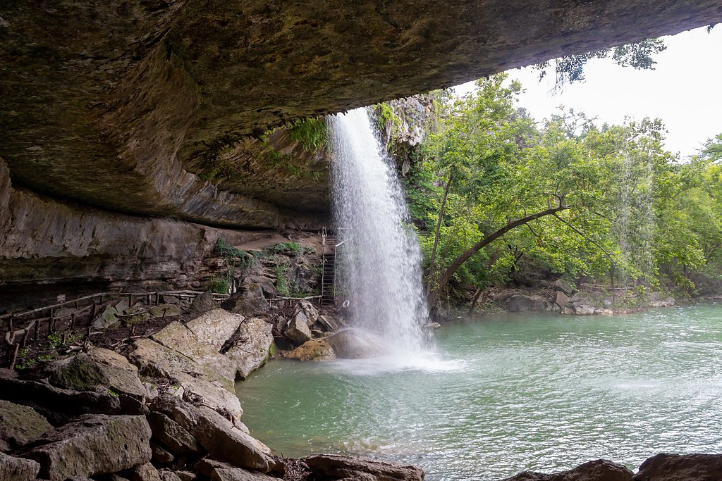

Photo Credits (5)
Difficulty
Moderate
Trail Length
2.4 miles
Trail Type
Out And Back
Elevation Gain
350 ft
About The Falls
Tucked into Gartrell Falls Ranch in Texas, The Falls is a photogenic cascade whose flow swells and softens with the seasons. Visitors come for the changing water display, birdlife and leafy surroundings; the site is listed under the Gartrell Falls Ranch land unit (Designation: PAGR) and is managed by a local NGO, while the recorded landowner is unknown. This makes it a quieter, less-developed waterfall experience compared with state or national forest sites, and access details can vary, so planning ahead is recommended. The waterfall is reached via a moderate out-and-back hike of 2.4 miles round trip with about 350 feet of elevation gain. The approach is rewarding for nature lovers and photographers looking for a short day outing that still feels secluded; check with the managing NGO for the latest access information and any seasonal advisories before you go.
The Setting
The Falls sits at 1,880 feet within Gartrell Falls Ranch, in the hills of Texas.
Trail & Hike Details
The Approach
The moderate 2.4-mile out-and-back trail gains 350 feet of elevation on the way to the falls.
Trail Description
Trail: 2.4 miles round trip (out-and-back); Elevation gain: ~350 ft; Difficulty: Moderate. There is no USFS trail name or number available for this route; official surface, grade and class data from the Forest Service are not documented for this trail. The route is a relatively short, natural-tread hike with variable conditions driven by seasonal rainfall, so expect uneven footing and possibly wet sections near the falls. Because access is on the Gartrell Falls Ranch parcel (managed by an NGO and with owner listed as unknown), hikers should verify current trail conditions and any access restrictions with the land manager before setting out and come prepared with sturdy footwear, water, and weather-appropriate gear.
What to Expect
Visitors can expect a natural waterfall setting that may be seasonal or dependent on rainfall. The surrounding area may include hiking trails, scenic views, and opportunities for photography.
Accessibility
The trail is not wheelchair accessible. Uneven terrain and elevation changes require steady footing.
Frequently Asked Questions
🐶 Are Dogs Allowed at The Falls?
❌ Dogs are not allowed
Are There Any Fees or Permits Required?
🆖 No fees required
🏊 Is There Swimming at The Falls?
❌ Swimming is not allowed
When to Visit
The best time to visit is typically after rainfall when the waterfall is likely to have the most flow. Spring and early summer are often ideal.
Seasonal Access
The best time to visit is Spring, Summer, Fall, and Winter.
Safety Information
Trail conditions may vary, and slippery rocks near the waterfall can pose a hazard. Visitors should exercise caution and avoid climbing on wet or unstable surfaces.
Current Water Conditions
Based on a USGS gauge 20.5 miles away
11 ft³/s
Current discharge — how much water is flowing
Much higher than usual for this time of year
Based on 62 years of record
7.38 ft
Water depth at gauge
7-Day Discharge Trend
What does this mean for your visit?
The water is flowing much higher than usual, expect an impressive display.
About This Gauge
This gauge is on a regional waterway. Conditions at the falls may differ, especially after local rain.
7-Day Flow Outlook
Based on the USGS gauge Beaver Ck nr Mason, TX (33 km away).
Today
Low
12 cfs
6/10Tomorrow
Low
10 cfs
6/10Wed
Low
7 cfs
6/10Thu
Low
8 cfs
6/10Fri
Low
8 cfs
6/10Sat
Moderate
8 cfs
5/10Sun
Moderate
7 cfs
8/10Best window: Sun — moderate flow, mostly sunny (trip score 8/10).
Best time of year: this gauge typically runs highest from late April to late May, peaking in March.
How we calculate this
This is a transparent outlook, not a precise forecast. We take the waterfall's current flow strength (how it ranks against its historical normal for today, from the nearest USGS stream gauge), carry that ranking forward along the gauge's seasonal curve, and nudge it for forecast rain. Confidence is highest for the next day or two and falls further out. Always check official conditions and your own judgment before visiting — high flows can be dangerous.
Know when to go.
Get a free email alert when waterfalls near Harper hit peak flow. We only send when conditions are worth the trip — no weekly newsletters, no spam.
Weather Forecast
Location & Access
Getting There
The exact location of The Falls in Texas can vary as there are multiple waterfalls referred to by this name. It is recommended to consult local resources or park services for precise directions.
Get Directions on Google MapsParking
Parking availability may depend on the specific location of The Falls. Visitors should check with local park authorities or trailheads for parking details.
Elevation
1,880 feet above sea level
Coordinates
30.408332° N, -99.306502° W
Land Management
Managed by NGO
Visitor Tips & Gear
Check weather conditions before visiting as water flow may be affected by recent rainfall. Wear sturdy footwear and bring water, as trail conditions may vary.
As an Amazon Associate, we earn from qualifying purchases.
With 2.4 miles and 350 ft of elevation gain, sturdy boots and trekking poles will help on this moderate trail. Icy conditions are common in winter — traction cleats are a smart addition.

Columbia Watertight II Rain Jacket
Packs into its own pocket, seam-sealed, and keeps you dry from spray and surprise rain.

Polarized Sunglasses (Knockaround)
Cuts glare off the water so you actually see the falls — and your photos turn out better too.

Earth Pak Waterproof Dry Bag
Keeps your phone and gear dry when waterfall mist soaks everything else.

Waterproof Phone Pouch (AiRunTech)
Cheap insurance — take photos right next to the falls without killing your phone.

Timberland Euro Sprint Mid Waterproof
Trusted waterproof boot with premium leather and grippy rubber sole — reliable on rocky, wet trails.

TrailBuddy Trekking Poles
Lightweight aluminum, cork grips, and flip-locks that actually hold — a best-seller for good reason.
Where to Stay

Fredericksburg Inn and Suites

SKYE Texas Hill Country Resort

Cowboys and Angels RV Park, Cabins, and Events

Airstream Getaway - Hot Tub & Fire Pit
Browse vacation cabins and private rentals nearby
Unique outdoor stays — tents, yurts, and treehouses
Rent a campervan or RV for your waterfall road trip
Some links are affiliate links. We may earn a commission at no extra cost to you.
Additional Information
Nearby Attractions
Nearby attractions may include other natural landmarks, hiking trails, or parks depending on the specific location of The Falls.
Wildlife
The area may feature local wildlife such as birds, deer, and small mammals. Visitors should be cautious and respectful of wildlife.
Cities near The Falls
Other waterfalls named The Falls
20 other waterfalls share this name across the U.S.
Writing about The Falls? Embed this waterfall on your site for free.