Photo Credits (5)
Difficulty
Moderate
Trail Length
2.4 miles
Trail Type
Out And Back
Elevation Gain
350 ft
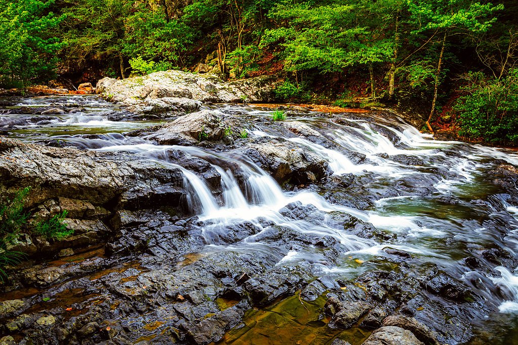
About The Falls
The Falls in Missouri is a pretty, seasonally variable cascade tucked into a woodland setting — its flow swells after rains and in spring runoff and softens to a trickle in drier months. Framed by green foliage in summer and stark branches in winter, the falls are a popular stop for photographers and hikers looking for a short, restorative nature outing. A moderate, out-and-back hike of about 2.4 miles (round trip) with roughly 350 feet of elevation gain leads to the viewpoint, making this a doable half-day trip for most outdoor enthusiasts. The nearest developed campground is Udall Park, about 17.7 km away, so plan overnight stays accordingly.
The Setting
The Falls sits at 643 feet along the North Fork River, in the foothills of Missouri.
Trail & Hike Details
The Approach
The moderate 2.4-mile out-and-back trail gains 350 feet of elevation on the way to the falls.
Trail Description
Trail type: out-and-back. Distance: 2.4 miles (round trip). Elevation gain: ~350 feet. Difficulty: Moderate. Official USFS trail name/number, surface, grade, and class are not published for this route, so trail conditions can vary. Expect a steady climb in places and bring sturdy footwear, water, and basic navigation awareness — the route is straightforward but may include variable natural tread.
What to Expect
Visitors can expect a peaceful natural setting with a waterfall that may be seasonal. The area is likely surrounded by forested landscapes, offering opportunities for photography and relaxation.
Accessibility
The trail is not wheelchair accessible. Uneven terrain and elevation changes require steady footing.
Frequently Asked Questions
🐶 Are Dogs Allowed at The Falls?
❌ Dogs are not allowed
Are There Any Fees or Permits Required?
🆖 No fees required
🏊 Is There Swimming at The Falls?
❌ Swimming is not allowed
When to Visit
Spring and early summer are typically the best times to visit, as water flow is often higher due to rainfall.
Seasonal Access
The best time to visit is Spring, Summer, and Fall. Winter access may be limited.
Safety Information
Visitors should be cautious of slippery rocks near the waterfall and uneven terrain. Check weather conditions before visiting, as heavy rainfall may make trails hazardous.
Current Water Conditions
777 ft³/s
Current discharge — how much water is flowing
Higher than usual for this time of year
Based on 81 years of record
2.98 ft
Water depth at gauge
7-Day Discharge Trend
What does this mean for your visit?
The water is flowing higher than usual for this time of year.
About This Gauge
This gauge is on a nearby waterway and may not reflect exact conditions at the falls.
7-Day Flow Outlook
Based on the USGS gauge North Fork River near Tecumseh, MO (9 km away).
Today
Moderate
886 cfs
4/10Tomorrow
Moderate
851 cfs
8/10Mon
Low
781 cfs
6/10Tue
Low
759 cfs
6/10Wed
Low
741 cfs
6/10Thu
Moderate
836 cfs
4/10Fri
Moderate
875 cfs
4/10Best window: Tomorrow — moderate flow, sunny (trip score 8/10).
Best time of year: this gauge typically runs highest from early March to early June, peaking in May.
How we calculate this
This is a transparent outlook, not a precise forecast. We take the waterfall's current flow strength (how it ranks against its historical normal for today, from the nearest USGS stream gauge), carry that ranking forward along the gauge's seasonal curve, and nudge it for forecast rain. Confidence is highest for the next day or two and falls further out. Always check official conditions and your own judgment before visiting — high flows can be dangerous.
Know when to go.
Get a free email alert when waterfalls near Bakersfield hit peak flow. We only send when conditions are worth the trip — no weekly newsletters, no spam.
Weather Forecast
Location & Access
Getting There
The exact location of The Falls in Missouri is not well-documented. Visitors are advised to consult local resources or hiking guides for directions.
Get Directions on Google MapsParking
Parking availability is unclear. Visitors should check with local authorities or nearby parks for parking options.
Elevation
643 feet above sea level
Coordinates
36.688117° N, -92.197379° W
Visitor Tips & Gear
Check local weather conditions before visiting, as water flow may depend on recent rainfall. Wear sturdy footwear and bring a map or GPS device if the trail is not well-marked.
As an Amazon Associate, we earn from qualifying purchases.
With 2.4 miles and 350 ft of elevation gain, sturdy boots and trekking poles will help on this moderate trail. Sun exposure on the trail makes good sun protection a must in summer.

Polarized Sunglasses (Knockaround)
Cuts glare off the water so you actually see the falls — and your photos turn out better too.

Columbia Watertight II Rain Jacket
Packs into its own pocket, seam-sealed, and keeps you dry from spray and surprise rain.

Earth Pak Waterproof Dry Bag
Keeps your phone and gear dry when waterfall mist soaks everything else.

Waterproof Phone Pouch (AiRunTech)
Cheap insurance — take photos right next to the falls without killing your phone.

Timberland Euro Sprint Mid Waterproof
Trusted waterproof boot with premium leather and grippy rubber sole — reliable on rocky, wet trails.

TrailBuddy Trekking Poles
Lightweight aluminum, cork grips, and flip-locks that actually hold — a best-seller for good reason.
Where to Stay

Quality Inn West Plains

Driftwood Resort Bull Shoals

Baymont by Wyndham West Plains

Holiday Inn Express & Suites West Plains Southwest by IHG
Browse vacation cabins and private rentals nearby
Unique outdoor stays — tents, yurts, and treehouses
Rent a campervan or RV for your waterfall road trip
Some links are affiliate links. We may earn a commission at no extra cost to you.
Nearby Campground
Udall Park
11 miles away · 9 sites
Overview Udall Park is for those looking for a more primitive campground conveniently located on the north end of Norfork Lake in Missouri. Recreation Sailing the open waters makes for an exciting water activity. Scuba diving in the lake is common, attracting divers from neighboring U.S. states. For visitors interested in fishing, Norfork Lake is stocked annually, and it's not unheard of to catch striped bass over 40 pounds. Facilities The 9 campsites within the park provide a more primitive ca
Book on Recreation.govAdditional Information
Nearby Attractions
Nearby attractions are not well-documented. Visitors may explore other natural areas or parks in Missouri.
Wildlife
The area may host typical Missouri wildlife, including birds, deer, and small mammals. Be cautious of ticks and other insects.
Cities near The Falls
Other waterfalls named The Falls
20 other waterfalls share this name across the U.S.
Writing about The Falls? Embed this waterfall on your site for free.