
Photo Credits (5)
Difficulty
Moderate
Trail Length
2.4 miles
Trail Type
Out And Back
Elevation Gain
350 ft
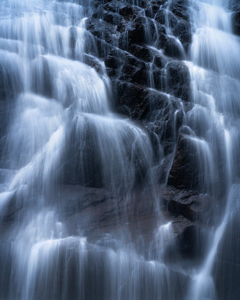
About The Falls
The Falls, located in Maine near the Canadian border, is a scenic waterfall surrounded by dense forest. It is a lesser-known destination, offering a peaceful retreat for nature enthusiasts. The waterfall may vary in flow depending on the season, with spring typically providing the most dramatic views due to snowmelt.
The Setting
The Falls sits at 1,575 feet along the S. Br. Penobscot River, in the hills of Maine.
Trail & Hike Details
The Approach
The moderate 2.4-mile out-and-back trail gains 350 feet of elevation on the way to the falls.
Trail Description
Details about the trail leading to The Falls are not well-documented. Visitors should prepare for potentially uneven terrain and bring appropriate footwear.
What to Expect
Expect a serene and remote waterfall surrounded by natural beauty. The area may be less developed, so amenities like restrooms or marked trails may not be available.
Accessibility
The trail is not wheelchair accessible. Uneven terrain and elevation changes require steady footing.
Frequently Asked Questions
🐶 Are Dogs Allowed at The Falls?
❌ Dogs are not allowed
Are There Any Fees or Permits Required?
🆖 No fees required
🏊 Is There Swimming at The Falls?
❌ Swimming is not allowed
When to Visit
Spring is ideal for viewing the waterfall at its fullest due to snowmelt. Summer and fall also offer pleasant conditions, with fall providing vibrant foliage.
Seasonal Access
The best time to visit is Spring, Summer, and Fall. Winter access may be limited.
Safety Information
The remote location means limited access to emergency services. Visitors should inform someone of their plans and carry a first aid kit. Be cautious of slippery rocks near the waterfall.
Current Water Conditions
Based on a USGS gauge 17.4 miles away
85 ft³/s
Current discharge — how much water is flowing
Lower than usual for this time of year
Based on 9 years of record
3.21 ft
Water depth at gauge
7-Day Discharge Trend
What does this mean for your visit?
Flow is lower than usual for this time of year.
About This Gauge
This gauge is on a regional waterway. Conditions at the falls may differ, especially after local rain.
7-Day Flow Outlook
Based on the USGS gauge S. Br. Penobscot River nr Canada Falls Lake, Maine (28 km away).
Today
Low
83 cfs
6/10Tomorrow
Low
120 cfs
5/10Tue
Low
70 cfs
6/10Wed
Moderate
84 cfs
4/10Thu
Moderate
134 cfs
5/10Fri
Low
121 cfs
6/10Sat
Moderate
90 cfs
4/10Best window: Today — low flow, mostly sunny (trip score 6/10).
Best time of year: this gauge typically runs highest from late March to late May, peaking in April.
How we calculate this
This is a transparent outlook, not a precise forecast. We take the waterfall's current flow strength (how it ranks against its historical normal for today, from the nearest USGS stream gauge), carry that ranking forward along the gauge's seasonal curve, and nudge it for forecast rain. Confidence is highest for the next day or two and falls further out. Always check official conditions and your own judgment before visiting — high flows can be dangerous.
Weather Forecast
Location & Access
Getting There
The Falls is located near the coordinates 45.7328, -70.2953. Access may require navigating rural roads, so a reliable map or GPS is recommended. The area is remote, and visitors should plan accordingly.
Get Directions on Google MapsParking
Parking availability is unclear, but visitors may need to park along nearby roads or at informal pull-offs. Confirm parking options before visiting.
Elevation
1,575 feet above sea level
Coordinates
45.732823° N, -70.295347° W
Visitor Tips & Gear
Bring a map or GPS device as cell service may be unreliable. Wear sturdy shoes and pack water and snacks. Be prepared for changing weather conditions.
As an Amazon Associate, we earn from qualifying purchases.
With 2.4 miles and 350 ft of elevation gain, sturdy boots and trekking poles will help on this moderate trail. Sun exposure on the trail makes good sun protection a must in summer.

Polarized Sunglasses (Knockaround)
Cuts glare off the water so you actually see the falls — and your photos turn out better too.

Columbia Watertight II Rain Jacket
Packs into its own pocket, seam-sealed, and keeps you dry from spray and surprise rain.

Earth Pak Waterproof Dry Bag
Keeps your phone and gear dry when waterfall mist soaks everything else.

Waterproof Phone Pouch (AiRunTech)
Cheap insurance — take photos right next to the falls without killing your phone.

Timberland Euro Sprint Mid Waterproof
Trusted waterproof boot with premium leather and grippy rubber sole — reliable on rocky, wet trails.

TrailBuddy Trekking Poles
Lightweight aluminum, cork grips, and flip-locks that actually hold — a best-seller for good reason.
Where to Stay

Unity Sky Lodge

All-Season Sanctuary: Steps to Moosehead Lake

Fun on Moosehead Lake

Mountainview Resort by Coolvacay
Browse vacation cabins and private rentals nearby
Unique outdoor stays — tents, yurts, and treehouses
Rent a campervan or RV for your waterfall road trip
Some links are affiliate links. We may earn a commission at no extra cost to you.
Additional Information
Nearby Attractions
The surrounding area offers opportunities for hiking and exploring the Maine wilderness. Nearby lakes and forests may also be of interest.
Wildlife
The area is home to a variety of wildlife, including birds, deer, and potentially moose. Be cautious and respectful of wildlife.
Nearby Waterfalls

Other waterfalls named The Falls
20 other waterfalls share this name across the U.S.
Writing about The Falls? Embed this waterfall on your site for free.