High Falls
Alabama • 35 ft
By Armen Suny · Last verified Mar 2026
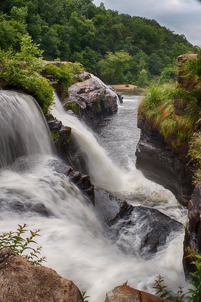
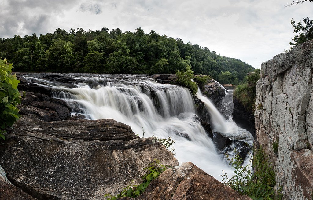
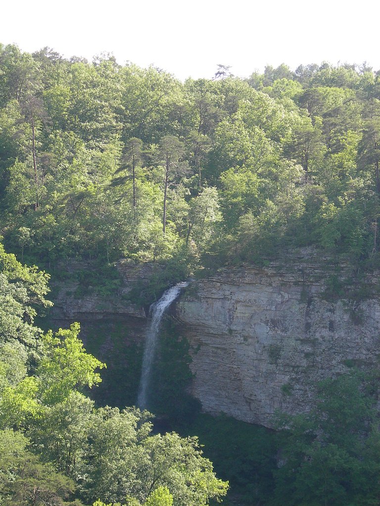
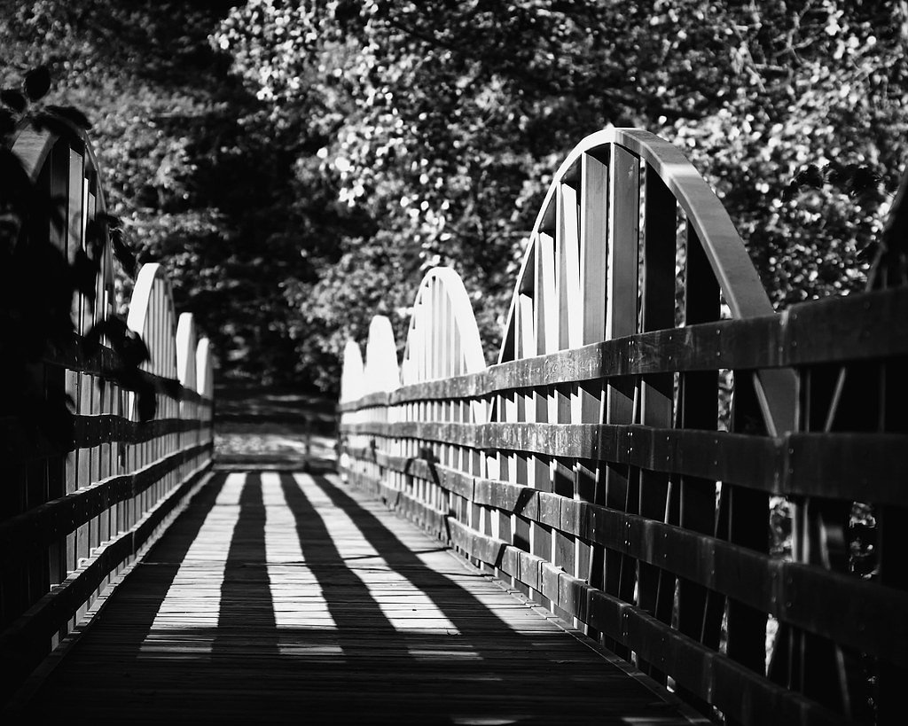
Photo Credits (5)
Difficulty
Moderate
Trail Length
2.4 miles
Trail Type
Out And Back
Elevation Gain
350 ft
About High Falls
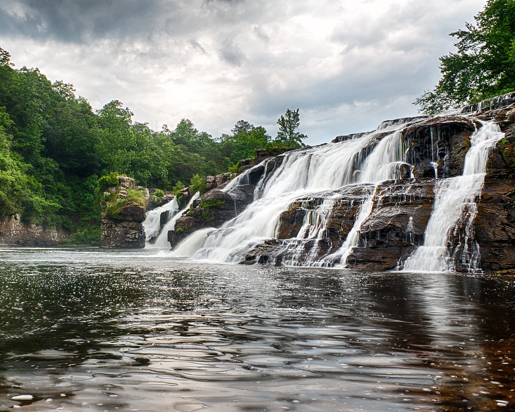
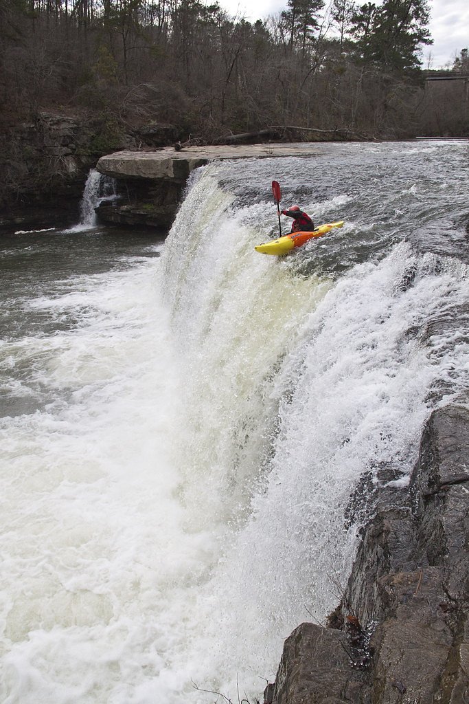
High Falls is a stunning 35-foot waterfall located in Alabama, known for its wide cascade and natural beauty. The waterfall is part of High Falls Park, which features a pedestrian bridge offering excellent views of the falls. The area is popular for picnicking, photography, and enjoying the serene surroundings.
The Setting
High Falls sits at 869 feet within High Falls Park, fed by the Town Creek, in the foothills of Alabama. The falls drop 35 feet.
Height: 35 feet
Trail & Hike Details
The Approach
The moderate 2.4-mile out-and-back trail gains 350 feet of elevation on the way to the falls.
Trail Description
The trail to High Falls is short and easy, making it accessible for most visitors. It is a well-maintained path that leads directly to the falls and the pedestrian bridge. The trail is suitable for families and those looking for a quick and scenic outing.
What to Expect
The falls drop 35 feet. Swimming is permitted. Dogs are welcome.
Accessibility
The trail is not wheelchair accessible. Uneven terrain and elevation changes require steady footing.
Frequently Asked Questions
🐶 Are Dogs Allowed at High Falls?
✅ Dogs are allowed
Are There Any Fees or Permits Required?
🆖 No fees required
🏊 Is There Swimming at High Falls?
✅ Swimming is allowed
When to Visit
Spring and early summer are the best times to visit High Falls, as the water flow is typically strongest during these seasons. However, the falls are beautiful year-round, and fall offers vibrant foliage, while winter provides a quieter experience.
Seasonal Access
The best time to visit is Spring, Summer, Fall, and Winter.
Safety Information
Exercise caution near the water, as rocks can be slippery. Avoid swimming during high water conditions or after heavy rainfall. Always supervise children near the falls and the water.
Current Water Conditions
15 ft³/s
Current discharge — how much water is flowing
About average for this time of year
Based on 9 years of record
0.81 ft
Water depth at gauge
7-Day Discharge Trend
What does this mean for your visit?
Flow is about average for this time of year.
About This Gauge
7-Day Flow Outlook
Based on the USGS gauge TOWN CREEK NEAR GERALDINE AL (8 km away).
Today
Barely Flowing
15 cfs
5/10Tomorrow
Low
14 cfs
3/10Thu
Low
14 cfs
3/10Fri
Low
11 cfs
3/10Sat
Low
9 cfs
3/10Sun
Low
8 cfs
3/10Mon
Low
7 cfs
3/10Best window: Today — barely flowing flow, sunny (trip score 5/10).
Best time of year: this gauge typically runs highest from mid February to late March, peaking in February.
How we calculate this
This is a transparent outlook, not a precise forecast. We take the waterfall's current flow strength (how it ranks against its historical normal for today, from the nearest USGS stream gauge), carry that ranking forward along the gauge's seasonal curve, and nudge it for forecast rain. Confidence is highest for the next day or two and falls further out. Always check official conditions and your own judgment before visiting — high flows can be dangerous.
Know when to go.
Get a free email alert when waterfalls near Geraldine hit peak flow. We only send when conditions are worth the trip — no weekly newsletters, no spam.
Weather Forecast
Location & Access
Getting There
High Falls is located near Geraldine, Alabama, approximately 4.8 miles away. The coordinates for the falls are 34.4001, -86.068. Visitors can access the falls via High Falls Park, which is well-marked and easily reachable by car.
Get Directions on Google MapsParking
There is a designated parking area at High Falls Park, located close to the waterfall. Parking is typically free, but availability may vary during peak seasons.
Elevation
869 feet above sea level
Coordinates
34.400093° N, -86.068001° W
Land Management
Managed by CNTY
Visitor Tips & Gear
Arrive early during weekends or holidays to secure parking and avoid crowds. Wear comfortable shoes for the short walk to the falls. Bring a camera to capture the stunning views, and consider packing a picnic to enjoy in the park's designated areas.
As an Amazon Associate, we earn from qualifying purchases.
With 2.4 miles and 350 ft of elevation gain, sturdy boots and trekking poles will help on this moderate trail. Icy conditions are common in winter — traction cleats are a smart addition.

Columbia Watertight II Rain Jacket
Packs into its own pocket, seam-sealed, and keeps you dry from spray and surprise rain.

Polarized Sunglasses (Knockaround)
Cuts glare off the water so you actually see the falls — and your photos turn out better too.

Earth Pak Waterproof Dry Bag
Keeps your phone and gear dry when waterfall mist soaks everything else.

Waterproof Phone Pouch (AiRunTech)
Cheap insurance — take photos right next to the falls without killing your phone.

Timberland Euro Sprint Mid Waterproof
Trusted waterproof boot with premium leather and grippy rubber sole — reliable on rocky, wet trails.

TrailBuddy Trekking Poles
Lightweight aluminum, cork grips, and flip-locks that actually hold — a best-seller for good reason.
Where to Stay

Home2 Suites By Hilton Guntersville

Wyndham Garden Lake Guntersville

Microtel Inn & Suites by Wyndham Albertville

Mountain Treehouse - Magpie Nest
Browse vacation cabins and private rentals nearby
Unique outdoor stays — tents, yurts, and treehouses
Rent a campervan or RV for your waterfall road trip
Some links are affiliate links. We may earn a commission at no extra cost to you.
Additional Information
Nearby Attractions
Nearby attractions include Lake Guntersville State Park, DeSoto State Park, and the town of Geraldine, which offers small-town charm and local dining options.
Wildlife
The area around High Falls is home to various bird species, small mammals, and aquatic life. Visitors may spot turtles, fish, and occasionally deer in the surrounding park.
Cities near High Falls
Nearby Waterfalls
Other waterfalls named High Falls
31 other waterfalls share this name across the U.S.
-
01
Bridgeville
Current flow 127 ft³/s -
02
Copenhagen
Current flow 443 ft³/s -
03
Cranberry Lake
Current flow 577 ft³/s -
04
Grahamsville
Current flow 5 ft³/s -
05
Lake Placid
Current flow 3 ft³/s -
06
Lyon Mountain
Current flow 122 ft³/s -
07
Lyon Mountain
-
08
Philmont
Current flow 118 ft³/s -
09
Prospect
Current flow 17 ft³/s -
10
Rochester
Current flow 1,900 ft³/s -
11
St. Regis Falls
Current flow 363 ft³/s
Writing about High Falls? Embed this waterfall on your site for free.