Photo Credits (5)
Difficulty
Moderate
Trail Length
6.8 miles
Trail Type
Out And Back
Elevation Gain
800 ft
About High Falls
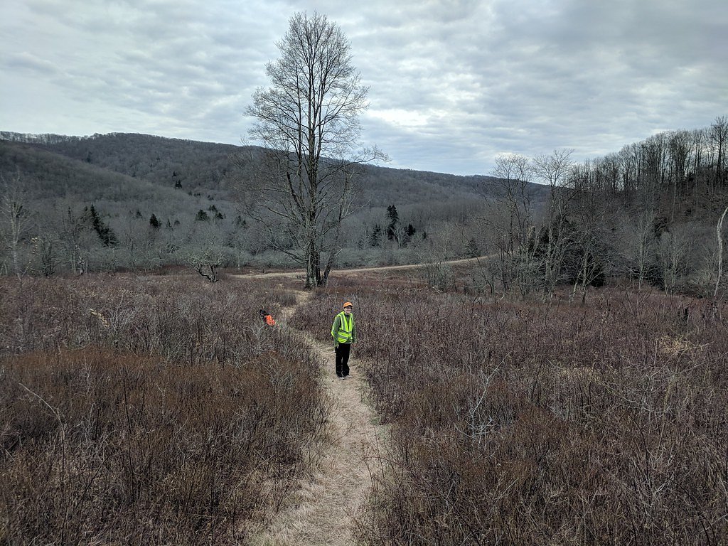
High Falls is a stunning waterfall located in the Monongahela National Forest in West Virginia. It is known for its remote location and scenic beauty, featuring a cascade of water over a rocky ledge surrounded by lush forest.
The Setting
High Falls sits at 2,884 feet within Monongahela National Forest, fed by the Shavers Fork, in the hills of West Virginia.
Trail & Hike Details
The Approach
The moderate hike follows High Falls (#345), a 6.8-mile out-and-back trail over natural surface. Expect 800 feet of elevation gain with grades of 10-12%. The trail is moderately developed (Class 2).
USFS Trail
HIGH FALLS #345
Trail Class
Moderately Developed
Surface
Avg Grade
USFS Segment
2.74 miTrail Description
The trail to High Falls is a moderately challenging hike through dense forest, with some sections featuring uneven terrain and moderate elevation gain. The trail follows the Shavers Fork River, offering scenic views along the way. The final approach to the falls includes a short descent to the base of the waterfall.
What to Expect
Dogs are welcome.
Accessibility
The trail is not wheelchair accessible. Uneven terrain and elevation changes require steady footing.
Frequently Asked Questions
🐶 Are Dogs Allowed at High Falls?
✅ Dogs are allowed
Are There Any Fees or Permits Required?
🆖 No fees required
🏊 Is There Swimming at High Falls?
❌ Swimming is not allowed
When to Visit
Spring and early summer are ideal for visiting High Falls, as the water flow is typically strongest during this time. Fall offers beautiful foliage, while summer provides warmer weather for hiking.
Seasonal Access
The best time to visit is Spring, Summer, and Fall. Winter access may be limited. Check with Monongahela National Forest for seasonal road closures.
Safety Information
The trail can be muddy and slippery, especially after rain. Visitors should watch for loose rocks and tree roots. Carry a map or GPS device, as the trail is in a remote area with limited cell service.
Current Water Conditions
3.42 ft
Water depth at gauge
66°F
CoolRefreshing for swimming
What does this mean for your visit?
Water temperature is a refreshing 66 degrees F, good for a quick swim.
About This Gauge
7-Day Flow Outlook
Based on the USGS gauge SHAVERS FORK AT BEMIS, WV (5 km away).
Best time of year: this gauge typically runs highest from early March to mid April, peaking in January.
How we calculate this
This is a transparent outlook, not a precise forecast. We take the waterfall's current flow strength (how it ranks against its historical normal for today, from the nearest USGS stream gauge), carry that ranking forward along the gauge's seasonal curve, and nudge it for forecast rain. Confidence is highest for the next day or two and falls further out. Always check official conditions and your own judgment before visiting — high flows can be dangerous.
Know when to go.
Get a free email alert when waterfalls near East Dailey hit peak flow. We only send when conditions are worth the trip — no weekly newsletters, no spam.
Weather Forecast
Location & Access
Getting There
High Falls can be accessed via the High Falls Trail, which begins near the Cheat Mountain area. The trailhead is located off Forest Road 44, and visitors should follow signs for the High Falls Trail.
Get Directions on Google MapsParking
Parking is available at the trailhead along Forest Road 44. Spaces may be limited, so arriving early is recommended.
Elevation
2,884 feet above sea level
Coordinates
38.772488° N, -79.777318° W
Land Management
Managed by USFS
Visitor Tips & Gear
Wear sturdy hiking shoes, as the trail can be muddy or slippery in places. Bring plenty of water and snacks, as there are no facilities along the trail. Cell service may be limited, so plan accordingly.
As an Amazon Associate, we earn from qualifying purchases.
With 6.8 miles and 800 ft of elevation gain, sturdy boots and trekking poles will help on this moderate trail. Sun exposure on the trail makes good sun protection a must in summer.

Polarized Sunglasses (Knockaround)
Cuts glare off the water so you actually see the falls — and your photos turn out better too.

Columbia Watertight II Rain Jacket
Packs into its own pocket, seam-sealed, and keeps you dry from spray and surprise rain.

Earth Pak Waterproof Dry Bag
Keeps your phone and gear dry when waterfall mist soaks everything else.

Waterproof Phone Pouch (AiRunTech)
Cheap insurance — take photos right next to the falls without killing your phone.

Timberland Euro Sprint Mid Waterproof
Trusted waterproof boot with premium leather and grippy rubber sole — reliable on rocky, wet trails.

TrailBuddy Trekking Poles
Lightweight aluminum, cork grips, and flip-locks that actually hold — a best-seller for good reason.
Where to Stay

BaseCampWV-Durbin. Spacious 4 bedroom house w/yard

Super 8 by Wyndham Elkins

Tygart Hotel, an Ascend Collection Hotel

Wingate by Wyndham Elkins
Browse vacation cabins and private rentals nearby
Unique outdoor stays — tents, yurts, and treehouses
Rent a campervan or RV for your waterfall road trip
Some links are affiliate links. We may earn a commission at no extra cost to you.
Nearby Campground
Laurel Fork Campground
5.1 miles away · 0 sites
Located along the Laurel Fork River between Laurel Fork North and South Wilderness areas, this primitive campground offers visitors a nice camping opportunity in the Middle Mountain area on the site of an old Civilian Conservation Corps location.Day hiking and backpacking opportunities are available leaving from this campground as well through the Laurel Fork North and South Wilderness.
Book on Recreation.govNearby Hot Springs
Hot springs near East Dailey, West Virginia
Thorn Spring
Thorn Spring flows at 72°F from Thorn Spring Park, a non-profit owned property just 14.5 meters from the road in Pendleton Coun...
Bragg Spring
Bragg Spring produces 75-degree water that flows 24.4 degrees above ambient temperature at 2,508 feet elevation in Highland Cou...
Bolar Spring
Bolar Spring flows at 73°F near Warm Springs in Bath County, Virginia, emerging 22 degrees above the 51°F ambient temperature a...

Warm Springs
Warm Springs flows at 95 degrees Fahrenheit, producing water 43.7 degrees above ambient temperature at 2,335 feet elevation in ...
Minnehaha Springs
Minnehaha Springs flows at 70°F from a roadside location just 27.5 meters from State Route 92 in Pocahontas County, West Virgin...
Looking for a soak after your hike? Explore more hot springs near East Dailey, West Virginia on SoakingSprings.
Explore West Virginia springsAdditional Information
Nearby Attractions
Nearby attractions include the Cheat Mountain Salamander scenic train ride and other hiking trails in the Monongahela National Forest.
Wildlife
The area is home to a variety of wildlife, including deer, black bears, and numerous bird species. Visitors should be cautious and follow Leave No Trace principles.
Cities near High Falls
Other waterfalls named High Falls
31 other waterfalls share this name across the U.S.
-
01
Bridgeville
Current flow 127 ft³/s -
02
Copenhagen
Current flow 443 ft³/s -
03
Cranberry Lake
Current flow 577 ft³/s -
04
Grahamsville
Current flow 5 ft³/s -
05
Lake Placid
Current flow 3 ft³/s -
06
Lyon Mountain
Current flow 122 ft³/s -
07
Lyon Mountain
-
08
Philmont
Current flow 118 ft³/s -
09
Prospect
Current flow 17 ft³/s -
10
Rochester
Current flow 1,900 ft³/s -
11
St. Regis Falls
Current flow 363 ft³/s
Writing about High Falls? Embed this waterfall on your site for free.