Photo Credits (1)
Difficulty
Drive Up
Trail Length
0.2 km
Trail Type
Out And Back
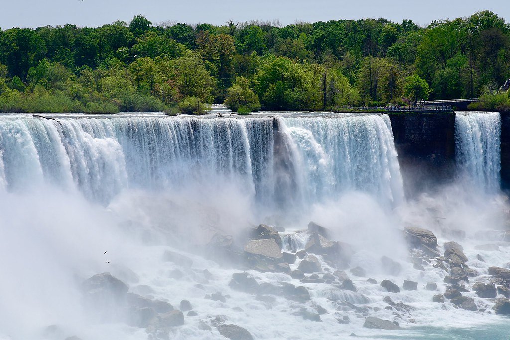
About High Falls
High Falls is a natural waterfall located near New Liskeard (approx. 4.6 miles) and Cobalt (approx. 6.0 miles) in northeastern Ontario (coordinates: 47.4635, -79.7336). The site is a scenic, likely rocky cascade in the Cobalt/New Liskeard region. Precise official trail infrastructure and the formally measured height are not confirmed; visitor reports indicate a rugged natural setting with good seasonal flow in spring and early summer and ice formations in winter.
Why This Waterfall Exists
High Falls flows over layered sedimentary rock laid down over 1.6-2.5 billion years ago. Over time, the stream has worn through these layers at different rates, creating the step that forms the waterfall.
Trail & Hike Details
The Approach
No hiking required. High Falls is accessible by vehicle with a roadside viewing area.
Trail Description
Trail and approach details are not consistently documented. Visitors commonly report a short, informal walk from a nearby parking/pullout to natural viewpoints. Expect uneven terrain, roots, rocks, and possibly short steep sections near the river edge. There may be no maintained boardwalks, handrails, or formal viewing platforms. Use caution on wet rock and near cliff edges.
What to Expect
A natural riverside waterfall setting with exposed rock and likely a narrow gorge or cascade. Stream flow will be highest in spring/snowmelt and after heavy rain; summer flows may be lower. There are likely no visitor facilities (restrooms, potable water, trash service). Cell service may be intermittent. In winter the falls may be heavily iced and very slippery, ice formations can be attractive but hazardous.
Accessibility
This waterfall is viewable from a vehicle-accessible area. No hiking is required.
Frequently Asked Questions
🐶 Are Dogs Allowed at High Falls?
❌ Dogs are not allowed
Are There Any Fees or Permits Required?
🆖 No fees required
🏊 Is There Swimming at High Falls?
❌ Swimming is not allowed
When to Visit
Spring (snowmelt/after rains) for highest flow and dramatic water; late spring/early summer for good access and greener surroundings; fall for foliage color. Winter offers ice formations but is hazardous and requires caution and winter skills/equipment.
Seasonal Access
The best time to visit is Spring, Summer, Fall, and Winter. Check with the managing park or local authority for current conditions.
Safety Information
Hazards include slippery rocks, steep or unstable edges, fast or cold water, limited or no railings, and variable trail conditions. Ice in winter greatly increases risk. Cell phone reception may be limited, carry a map and tell someone your plans. If visiting after heavy rain or during spring melt, exercise extra caution due to high flows and potential flooding.
7-Day Flow Outlook
Based on the WSC gauge MONTREAL RIVER AT MOUNTAIN CHUTES (40 km away).
Best time of year: this gauge typically runs highest from mid April to early July, peaking in May.
How we calculate this
This is a transparent outlook, not a precise forecast. We take the waterfall's current flow strength (how it ranks against its historical normal for today, from the nearest WSC stream gauge), carry that ranking forward along the gauge's seasonal curve, and nudge it for forecast rain. Confidence is highest for the next day or two and falls further out. Always check official conditions and your own judgment before visiting — high flows can be dangerous.
Know when to go.
Get a free email alert when waterfalls near New Liskeard hit peak flow. We only send when conditions are worth the trip — no weekly newsletters, no spam.
Weather Forecast
Location & Access
Getting There
The waterfall is reached by driving from New Liskeard or Cobalt toward the provided coordinates (47.4635, -79.7336). Access typically involves local secondary or gravel roads and a short walk from a nearby parking or pullout. Road and parking conditions may vary seasonally; a high-clearance vehicle may be useful in poor conditions. Exact official access points, trailheads, or signage are not confirmed here, use the coordinates and local maps to plan the final approach.
Get Directions on Google MapsParking
Likely roadside pullout or small informal parking area. Parking is likely limited and may be unmarked; do not block private driveways or gates. Expect no formal lot, toilets, or services.
Elevation
263 metres above sea level
Coordinates
47.463485° N, -79.733604° W
Visitor Tips & Gear
• Wear sturdy, closed-toe footwear with good traction. • Stay back from the edge; rocks can be slippery and unstable. • Bring insect repellent (ticks and mosquitoes can be active in warmer months). • Carry water and a small first-aid kit; do not rely on cell service. • Pack out all trash. • Check local conditions (road, river flow, seasonal access) before visiting. • If unsure whether access crosses private land, verify with local authorities or community resources.
Where to Stay
Browse vacation cabins and private rentals nearby
Unique outdoor stays — tents, yurts, and treehouses
Rent a campervan or RV for your waterfall road trip
Some links are affiliate links. We may earn a commission at no extra cost to you.
Nearby Campground
Hearst Lake - 4
20.3 km away
Additional Information
Nearby Attractions
Cobalt and New Liskeard area attractions (historic mining sites and museums in Cobalt, Lake Temiskaming shoreline areas, regional hiking and fishing opportunities). Confirm exact distances and opening hours locally.
Wildlife
Typical northeastern Ontario wildlife may be present: white-tailed deer, black bear, moose, beaver, smaller mammals, and various bird species. Ticks and mosquitoes can be common in warmer months.
Cities near High Falls
Nearby Waterfalls
Other waterfalls named High Falls
31 other waterfalls share this name across Canada.
-
01
Bridgeville
Current flow 130 ft³/s -
02
Copenhagen
Current flow 504 ft³/s -
03
Cranberry Lake
Current flow 192 ft³/s -
04
Grahamsville
Current flow 3 ft³/s -
05
Lake Placid
Current flow 1 ft³/s -
06
Lyon Mountain
Current flow 50 ft³/s -
07
Lyon Mountain
-
08
Philmont
Current flow 107 ft³/s -
09
Prospect
Current flow 5 ft³/s -
10
Rochester
Current flow 971 ft³/s -
11
St. Regis Falls
Current flow 120 ft³/s
Writing about High Falls? Embed this waterfall on your site for free.