High Falls
By Armen Suny · Last verified Jun 2026
Photo Credits (1)
Difficulty
Moderate
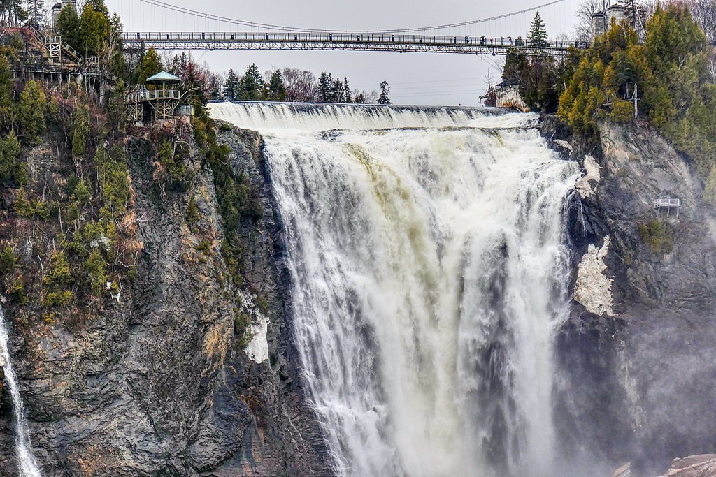
About High Falls
High Falls (coords ~45.5958, -76.338) is a river cascade in the Ottawa/Pembroke region. It is best described as a scenic waterfall on a forested river likely reachable from local roads. Specifics about official park boundaries, exact measured height, and maintained facilities are not confidently confirmed and may vary depending on which local access point is used.
Why This Waterfall Exists
High Falls flows over hard crystalline rock, primarily marble, laid down over 1.0-1.6 billion years ago. These resistant rocks form a durable ledge that water cannot easily wear away, creating the falls where softer material downstream has already eroded.
Trail & Hike Details
Trail Description
Visitors should expect limited or minimally maintained trails from the nearest roadside parking to viewpoints. Access may involve short bushwhacks or rocky scrambles to reach good vantage points. There may be no boardwalks, railings or signage immediately at the falls. In winter the approach can be icy and snow-covered and may require traction aids.
What to Expect
Scenic river cascades with variable flow, high and dramatic in spring melt, lower in late summer. Natural rock outcrops and forested surroundings. Potential for slippery, uneven surfaces and limited formal infrastructure. Cell service may be spotty. Wildlife such as birds, small mammals, and insects are typical. There may be limited visitor facilities.
Accessibility
The trail is not wheelchair accessible. Uneven terrain and elevation changes require steady footing.
Frequently Asked Questions
🐶 Are Dogs Allowed at High Falls?
❌ Dogs are not allowed
Are There Any Fees or Permits Required?
🆖 No fees required
🏊 Is There Swimming at High Falls?
❌ Swimming is not allowed
When to Visit
Spring (high flow) for the most dramatic water, early fall for foliage and comfortable temps. Summer offers easier access but lower flows. Winter can be scenic if frozen but poses additional hazards and access difficulties.
Seasonal Access
The best time to visit is Spring, Summer, Fall, and Winter. Check with the managing park or local authority for current conditions.
Safety Information
Hazards may include slippery wet rock, unstable edges, strong currents, sudden water level changes (especially during spring runoff or after heavy rain), cold water temperatures, limited cell service, and seasonal ice. Do not approach cliff edges, avoid entering fast-moving water, and supervise children. Bring communication and emergency supplies. If uncertain about route/conditions, consult local authorities or experienced hikers.
Current Water Conditions
18.8 m³/s
Current discharge — how much water is flowing
Much higher than usual for this time of year
Based on 104 years of record
5.95 m
Water depth at gauge
7-Day Discharge Trend
What does this mean for your visit?
The water is flowing much higher than usual, expect an impressive display.
About This Gauge
This gauge is on a nearby waterway and may not reflect exact conditions at the falls.
7-Day Flow Outlook
Based on the WSC gauge BONNECHERE RIVER NEAR CASTLEFORD (21 km away).
Today
Roaring
19 m³/s
9/10Tomorrow
Roaring
17 m³/s
8/10Tue
Roaring
19 m³/s
6/10Wed
Roaring
20 m³/s
6/10Thu
Roaring
19 m³/s
6/10Fri
Roaring
19 m³/s
6/10Sat
Roaring
18 m³/s
8/10Best window: Today — roaring flow, mainly sunny (trip score 9/10).
Best time of year: this gauge typically runs highest from mid March to mid June, peaking in April.
How we calculate this
This is a transparent outlook, not a precise forecast. We take the waterfall's current flow strength (how it ranks against its historical normal for today, from the nearest WSC stream gauge), carry that ranking forward along the gauge's seasonal curve, and nudge it for forecast rain. Confidence is highest for the next day or two and falls further out. Always check official conditions and your own judgment before visiting — high flows can be dangerous.
Know when to go.
Get a free email alert when waterfalls near Ottawa hit peak flow. We only send when conditions are worth the trip — no weekly newsletters, no spam.
Weather Forecast
Location & Access
Getting There
General approach: travel from Ottawa (roughly 35–40 miles west/northwest) or from Pembroke (roughly 40–45 miles east/southeast) toward the coordinates 45.5958, -76.338. Expect country roads and possible short gravel access roads. There may not be signed highway turnoffs. Use a GPS with the supplied coordinates and check recent local trip reports for the best access route.
Get Directions on Google MapsParking
Parking may be informal (small pullouts or roadside areas). There may be no official parking lot or facilities; parking availability and legality may vary. Park only where permitted and avoid blocking narrow roads.
Elevation
125 metres above sea level
Coordinates
45.595778° N, -76.338033° W
Visitor Tips & Gear
• Use the provided coordinates and recent trip reports or local resources to confirm access before you go. • Wear sturdy, waterproof footwear with good grip. • Be cautious on wet rocks and near edges; currents can be strong and water is cold. • Leave no trace: pack out what you bring in. • Check seasonal conditions (spring runoff, fall wet weather, winter ice). • Expect limited or no cell reception; let someone know your plans if going off-road.
Where to Stay
Browse vacation cabins and private rentals nearby
Unique outdoor stays — tents, yurts, and treehouses
Rent a campervan or RV for your waterfall road trip
Some links are affiliate links. We may earn a commission at no extra cost to you.
Nearby Campground
Camp Scout Impeesa
12.8 km away
Additional Information
Nearby Attractions
Nearest larger centers: Ottawa (~35–40 miles) and Pembroke (~40–45 miles). There may be local provincial parks, trails, or river access points within driving distance, check regional tourism or park agency resources for confirmed nearby attractions.
Wildlife
Typical temperate mixed-wood forest species: songbirds, woodpeckers, small mammals (squirrels, raccoons), white-tailed deer, and seasonal insects. Be aware of ticks in warmer months.
Cities near High Falls
Other waterfalls named High Falls
31 other waterfalls share this name across Canada.
-
01
Bridgeville
Current flow 178 ft³/s -
02
Copenhagen
Current flow 434 ft³/s -
03
Cranberry Lake
Current flow 185 ft³/s -
04
Grahamsville
Current flow 8 ft³/s -
05
Lake Placid
-
06
Lyon Mountain
Current flow 70 ft³/s -
07
Lyon Mountain
-
08
Philmont
Current flow 89 ft³/s -
09
Prospect
Current flow 7 ft³/s -
10
Rochester
Current flow 2,390 ft³/s -
11
St. Regis Falls
Writing about High Falls? Embed this waterfall on your site for free.