Photo Credits (1)
Difficulty
Easy
Trail Length
0.6 km
Trail Type
Out And Back
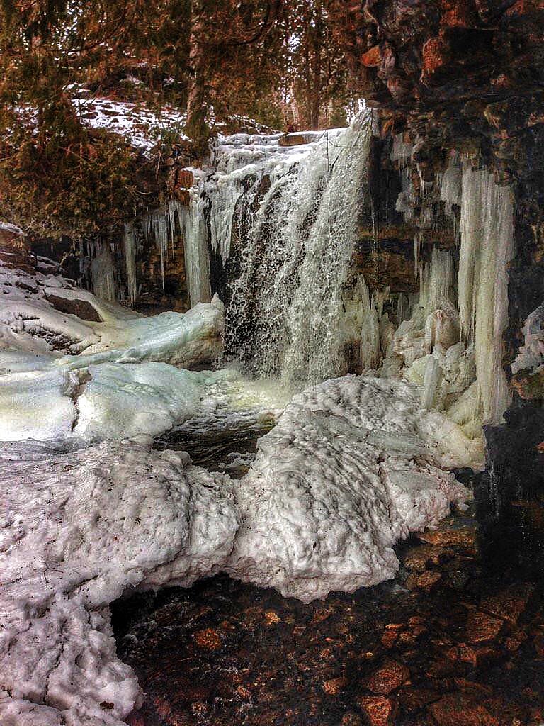
About High Falls
High Falls is a remote, scenic waterfall located in northeastern Ontario, approximately as given by coordinates 47.7962, -79.8868 and near the communities of New Liskeard, Cobalt and Rouyn‑Noranda. The falls sit in a forested boreal landscape and are best known for strong spring flows and a rugged, natural setting. Precise published information about official trail infrastructure and exact waterfall measurements appears limited; the description below is based on local/regional access patterns and typical conditions for waterfalls in this region.
The Setting
High Falls sits at 207 metres within Kap-Kig-Iwan Provincial Park, in the foothills of Ontario. The falls drop 12 metres.
Why This Waterfall Exists
High Falls flows over hard volcanic rock, primarily basalt and iron formation, laid down over 2.5-3.2 billion years ago. These resistant rocks form a durable ledge that water cannot easily wear away, creating a 39-foot drop where softer material downstream has already eroded.
Nearby Falls Worth Visiting
80 foot waterfall (24 m) lies 11.7 kilometres to the north.
Trail & Hike Details
Trail Description
Approach is typically via unmarked or lightly used walking routes through mixed forest and over uneven, rocky ground. The final approach to the falls may include short steep sections, wet rocks, roots and loose footing. There may be little to no maintained boardwalks, railings, or signage; visitors should follow obvious game or footpaths and avoid unstable banks near the water.
What to Expect
The falls drop 12 metres over hard volcanic rock.
Accessibility
The trail is short and relatively flat, but the surface may be uneven. Contact the managing agency for accessibility details.
Frequently Asked Questions
🐶 Are Dogs Allowed at High Falls?
❌ Dogs are not allowed
Are There Any Fees or Permits Required?
🆖 No fees required
🏊 Is There Swimming at High Falls?
❌ Swimming is not allowed
When to Visit
Late spring (snowmelt) for highest flows and dramatic waterfalls; early fall for fall colours and cooler, drier hiking conditions. Summer is good for access but flows may be reduced. Winter offers a frozen, scenic experience but requires winter safety gear and caution on ice.
Seasonal Access
The best time to visit is Spring, Summer, Fall, and Winter. Check with Kap-Kig-Iwan Provincial Park for current conditions.
Safety Information
Hazards include slippery wet rock, steep or unstable edges, swift currents, cold water shock, variable weather, poor cell coverage and seasonal road closures. Exercise caution near the water and on cliff edges, supervise children closely, and avoid risky photo or climbing behavior. If winter visiting, use traction devices and be aware of avalanche/icefall risk on cliffs and under overhangs. Check local forestry and road reports before travel.
7-Day Flow Outlook
Based on the WSC gauge BLANCHE RIVER ABOVE ENGLEHART (10 km away).
Best time of year: this gauge typically runs highest from early April to mid June, peaking in May.
How we calculate this
This is a transparent outlook, not a precise forecast. We take the waterfall's current flow strength (how it ranks against its historical normal for today, from the nearest WSC stream gauge), carry that ranking forward along the gauge's seasonal curve, and nudge it for forecast rain. Confidence is highest for the next day or two and falls further out. Always check official conditions and your own judgment before visiting — high flows can be dangerous.
Know when to go.
Get a free email alert when waterfalls near New Liskeard hit peak flow. We only send when conditions are worth the trip — no weekly newsletters, no spam.
Weather Forecast
Location & Access
Getting There
The waterfall is located off secondary and forest roads northeast of New Liskeard. Final approach is likely along unpaved logging or township roads and may require a short hike from an informal parking area. Use the coordinates (47.7962, -79.8868) with a GPS unit or mapping app. Expect limited signage and variable road conditions; 4WD or high-clearance vehicles may be useful on muddy or rutted forest roads.
Get Directions on Google MapsParking
Parking is likely informal (roadside pullout or small gravel turnouts). There may be no maintained trailhead parking, vault toilets, or other facilities. Park clear of the road and avoid blocking gates or logging operations.
Elevation
207 metres above sea level
Coordinates
47.796249° N, -79.886848° W
Land Management
Managed by Ontario Parks
Visitor Tips & Gear
1) Use the coordinates and a reliable map or GPS, signage and trail markings may be minimal. 2) Wear sturdy, waterproof footwear with good traction; expect wet and slippery rocks. 3) Bring insect repellent and check for ticks in warmer months. 4) Tell someone your plans; remote areas can have limited cellphone coverage. 5) Respect private land and forestry operations, do not block gates or roads. 6) Pack out all trash and follow Leave No Trace. 7) Exercise caution near edges and fast water; do not climb on unstable cliffs.
Where to Stay
Browse vacation cabins and private rentals nearby
Unique outdoor stays — tents, yurts, and treehouses
Rent a campervan or RV for your waterfall road trip
Some links are affiliate links. We may earn a commission at no extra cost to you.
Nearby Campground
Kap-Kig-Iwan Park Campground
0.5 km away
Additional Information
Nearby Attractions
Communities of New Liskeard (approx. 24 miles), Cobalt (approx. 29 miles) and Rouyn‑Noranda (approx. 59 miles) offer services and points of interest. The Cobalt area has historic silver mine sites and museums; the broader region includes numerous lakes, provincial parks and backcountry roads for fishing and canoeing.
Wildlife
Typical boreal wildlife may include moose, black bear, white‑tailed deer, beavers, otters, wolves and a variety of songbirds and waterfowl. Always store food securely and maintain distance from wildlife.
Cities near High Falls
Nearby Waterfalls
Other waterfalls named High Falls
31 other waterfalls share this name across Canada.
-
01
Bridgeville
Current flow 136 ft³/s -
02
Copenhagen
Current flow 524 ft³/s -
03
Cranberry Lake
-
04
Grahamsville
Current flow 3 ft³/s -
05
Lake Placid
Current flow 1 ft³/s -
06
Lyon Mountain
Current flow 58 ft³/s -
07
Lyon Mountain
-
08
Philmont
Current flow 76 ft³/s -
09
Prospect
Current flow 6 ft³/s -
10
Rochester
Current flow 680 ft³/s -
11
St. Regis Falls
Current flow 138 ft³/s
Writing about High Falls? Embed this waterfall on your site for free.