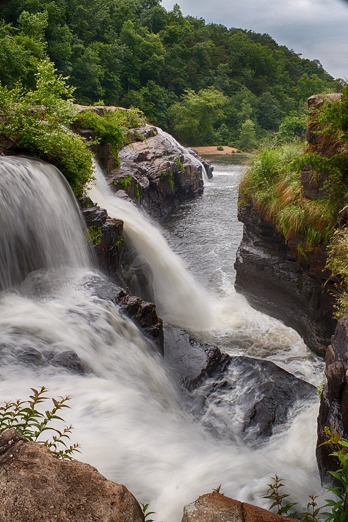
Griffin Falls
Alabama • 40 ft
By Armen Suny · Last verified May 2026
Difficulty
Moderate
Trail Length
2.4 miles
Trail Type
Out And Back
Elevation Gain
350 ft
About Griffin Falls
Griffin Falls is a scenic waterfall located in northeastern Alabama, near the town of Collinsville. It is a popular spot for hikers and climbers, as the area features both the waterfall and nearby rock climbing opportunities. The waterfall is surrounded by lush forest, making it a picturesque destination.
The Setting
Griffin Falls sits at 863 feet along the Town Creek, in the foothills of Alabama. The falls drop 40 feet.
Height: 40 feet
Trail & Hike Details
The Approach
The moderate 2.4-mile out-and-back trail gains 350 feet of elevation on the way to the falls.
Trail Description
The trail to Griffin Falls is short and relatively easy, making it accessible for most visitors. It passes through a wooded area and leads directly to the base of the waterfall. The trail may be uneven in places, so sturdy footwear is recommended.
What to Expect
The falls drop 40 feet. Dogs are welcome.
Accessibility
The trail is not wheelchair accessible. Uneven terrain and elevation changes require steady footing.
Frequently Asked Questions
🐶 Are Dogs Allowed at Griffin Falls?
✅ Dogs are allowed
Are There Any Fees or Permits Required?
🆖 No fees required
🏊 Is There Swimming at Griffin Falls?
❌ Swimming is not allowed
When to Visit
Spring and early summer are ideal times to visit, as the waterfall typically has the most water flow during these seasons.
Seasonal Access
The best time to visit is Spring, Summer, Fall, and Winter.
Safety Information
Exercise caution near the waterfall, as rocks can be slippery. Be aware of your surroundings and avoid climbing on wet or unstable surfaces. Cell phone reception may be limited in the area.
Current Water Conditions
15 ft³/s
Current discharge — how much water is flowing
About average for this time of year
Based on 9 years of record
0.81 ft
Water depth at gauge
7-Day Discharge Trend
What does this mean for your visit?
Flow is about average for this time of year.
About This Gauge
This gauge is on a nearby waterway and may not reflect exact conditions at the falls.
7-Day Flow Outlook
Based on the USGS gauge TOWN CREEK NEAR GERALDINE AL (12 km away).
Today
Barely Flowing
15 cfs
5/10Tomorrow
Low
14 cfs
3/10Thu
Low
14 cfs
3/10Fri
Low
11 cfs
3/10Sat
Low
9 cfs
3/10Sun
Low
8 cfs
3/10Mon
Low
7 cfs
3/10Best window: Today — barely flowing flow, sunny (trip score 5/10).
Best time of year: this gauge typically runs highest from mid February to late March, peaking in February.
How we calculate this
This is a transparent outlook, not a precise forecast. We take the waterfall's current flow strength (how it ranks against its historical normal for today, from the nearest USGS stream gauge), carry that ranking forward along the gauge's seasonal curve, and nudge it for forecast rain. Confidence is highest for the next day or two and falls further out. Always check official conditions and your own judgment before visiting — high flows can be dangerous.
Know when to go.
Get a free email alert when waterfalls near Crossville hit peak flow. We only send when conditions are worth the trip — no weekly newsletters, no spam.
Weather Forecast
Location & Access
Getting There
Griffin Falls is located off Highway 11 near Collinsville, Alabama. Visitors can park near the roadside and follow a short trail to the waterfall. The trailhead is not well-marked, so using GPS coordinates or a detailed map is recommended.
Get Directions on Google MapsParking
Roadside parking is available near the trailhead, but space may be limited. Visitors should park safely off the road.
Elevation
863 feet above sea level
Coordinates
34.287360° N, -85.930379° W
Visitor Tips & Gear
Bring sturdy shoes as the trail can be uneven. Consider visiting after a recent rain for the best water flow. Be cautious of slippery rocks near the waterfall.
As an Amazon Associate, we earn from qualifying purchases.
With 2.4 miles and 350 ft of elevation gain, sturdy boots and trekking poles will help on this moderate trail. Icy conditions are common in winter — traction cleats are a smart addition.

Columbia Watertight II Rain Jacket
Packs into its own pocket, seam-sealed, and keeps you dry from spray and surprise rain.

Earth Pak Waterproof Dry Bag
Keeps your phone and gear dry when waterfall mist soaks everything else.

Waterproof Phone Pouch (AiRunTech)
Cheap insurance — take photos right next to the falls without killing your phone.

Timberland Euro Sprint Mid Waterproof
Trusted waterproof boot with premium leather and grippy rubber sole — reliable on rocky, wet trails.

TrailBuddy Trekking Poles
Lightweight aluminum, cork grips, and flip-locks that actually hold — a best-seller for good reason.

Kahtoola MICROspikes
Cult-favorite traction cleats that grip ice and wet rock — essential for winter waterfall hikes.
Where to Stay

avid hotel Fort Payne by IHG

Microtel Inn & Suites by Wyndham Albertville

Candlewood Suites Fort Payne by IHG

Wyndham Garden Lake Guntersville
Browse vacation cabins and private rentals nearby
Unique outdoor stays — tents, yurts, and treehouses
Rent a campervan or RV for your waterfall road trip
Some links are affiliate links. We may earn a commission at no extra cost to you.
Additional Information
Nearby Attractions
Nearby attractions include Little River Canyon National Preserve and DeSoto State Park, both of which offer additional hiking and scenic views.
Wildlife
The area is home to various bird species, small mammals, and reptiles. Visitors may also see wildflowers in bloom during spring.
Cities near Griffin Falls
Nearby Waterfalls
Writing about Griffin Falls? Embed this waterfall on your site for free.