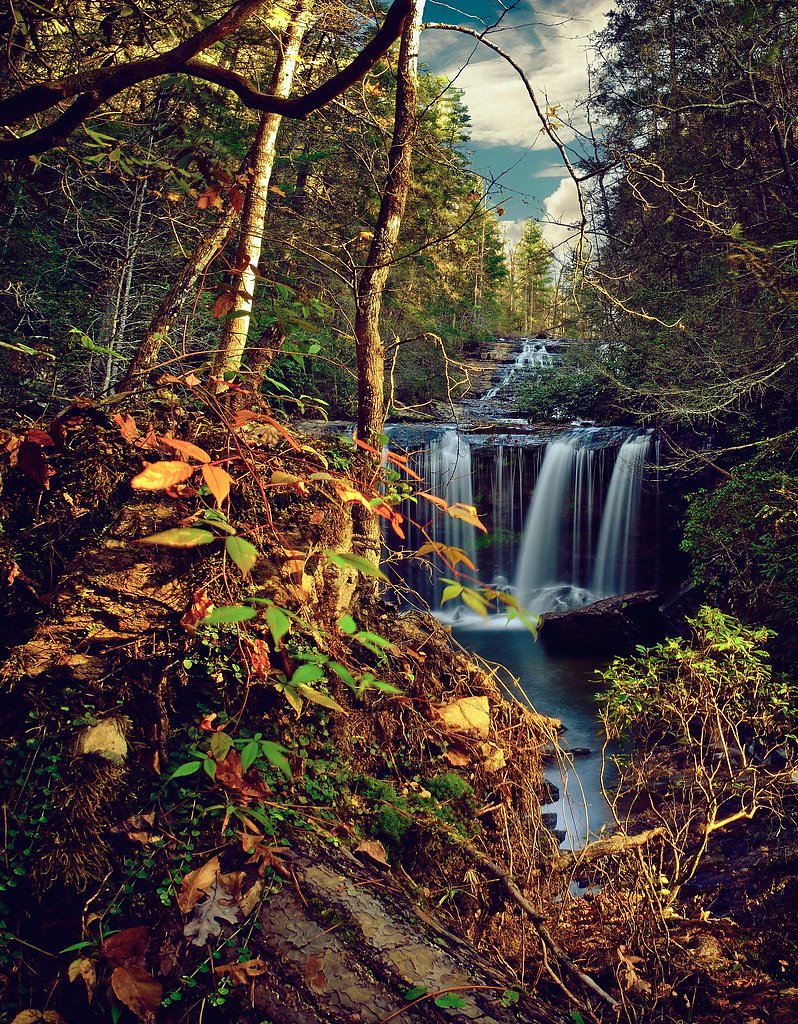
High Falls
By Armen Suny · Last verified May 2026
Difficulty
Moderate
Trail Length
2.4 miles
Trail Type
Out And Back
Elevation Gain
350 ft
About High Falls
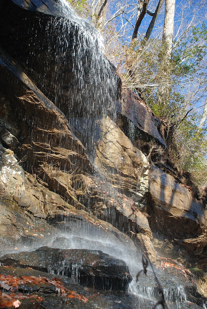
High Falls is a scenic South Carolina waterfall fronted by a photogenic cascade and verdant, forested surroundings. The waterfall is commonly visited by hikers and photographers seeking a relatively short outing that still feels immersive; the route to the falls is a 2.4-mile out-and-back with about 350 feet of elevation gain and is generally rated moderate in difficulty. The trail leads you through mixed woods and opens to a viewing area where the falls can be enjoyed and photographed. Plan for a moderate hike rather than a quick roadside stop: the round-trip distance and gain reward visitors with a peaceful, leafy approach and a satisfying view at the end. The nearest designated day-use/camping facility is the Twin Lakes Day Use Area, approximately 17.1 km (about 10.6 miles) from the falls, so overnight options are not immediately adjacent and should be arranged in advance.
The Setting
High Falls sits at 794 feet along the Twelvemile Creek, in the foothills of South Carolina.
Trail & Hike Details
The Approach
The moderate 2.4-mile out-and-back trail gains 350 feet of elevation on the way to the falls.
Trail Description
Length: 2.4 miles (out-and-back). Elevation gain: ~350 feet. Difficulty: Moderate. Trail type: Out-and-back. The trail follows a forested route to a viewing area at the waterfall. Over the 2.4-mile round trip hikers will climb roughly 350 feet, making for moderate exertion but no technical scrambling; footing and surface specifics from USFS trail data are not provided. Expect a single well-defined path through woods that culminates at the falls' viewing spot—suitable for hikers comfortable with a moderate, short hike.
What to Expect
Dogs are welcome.
Accessibility
The trail is not wheelchair accessible. Uneven terrain and elevation changes require steady footing.
Frequently Asked Questions
🐶 Are Dogs Allowed at High Falls?
✅ Dogs are allowed
Are There Any Fees or Permits Required?
🆖 No fees required
🏊 Is There Swimming at High Falls?
❌ Swimming is not allowed
When to Visit
Spring and fall are ideal for visiting due to pleasant weather and vibrant foliage. Summer is also popular, but it may be more crowded.
Seasonal Access
The best time to visit is Spring, Summer, and Fall. Winter access may be limited.
Safety Information
Exercise caution near the waterfall as rocks may be slippery. Avoid visiting during heavy rain or after storms as the trail may become hazardous.
Current Water Conditions
52 ft³/s
Current discharge — how much water is flowing
Much lower than usual for this time of year
Based on 44 years of record
1.68 ft
Water depth at gauge
7-Day Discharge Trend
What does this mean for your visit?
Flow is well below normal for this time of year, so the waterfall may be a trickle.
About This Gauge
This gauge is on a nearby waterway and may not reflect exact conditions at the falls.
7-Day Flow Outlook
Based on the USGS gauge TWELVEMILE CREEK NEAR LIBERTY, SC (16 km away).
Today
Moderate
53 cfs
5/10Tomorrow
Moderate
54 cfs
8/10Thu
Low
55 cfs
6/10Fri
Moderate
62 cfs
4/10Sat
Moderate
57 cfs
8/10Sun
Moderate
59 cfs
4/10Mon
Moderate
63 cfs
4/10Best window: Tomorrow — moderate flow, sunny (trip score 8/10).
Best time of year: this gauge typically runs highest from late February to late April, peaking in March.
How we calculate this
This is a transparent outlook, not a precise forecast. We take the waterfall's current flow strength (how it ranks against its historical normal for today, from the nearest USGS stream gauge), carry that ranking forward along the gauge's seasonal curve, and nudge it for forecast rain. Confidence is highest for the next day or two and falls further out. Always check official conditions and your own judgment before visiting — high flows can be dangerous.
Know when to go.
Get a free email alert when waterfalls near Keowee Key hit peak flow. We only send when conditions are worth the trip — no weekly newsletters, no spam.
Weather Forecast
Location & Access
Getting There
High Falls is located within the Sumter National Forest in South Carolina. Access is typically via a trailhead that can be reached by car. Specific directions may vary depending on the chosen route.
Get Directions on Google MapsParking
Parking is available near the trailhead, but spaces may be limited during peak seasons.
Elevation
794 feet above sea level
Coordinates
34.811211° N, -82.922647° W
Visitor Tips & Gear
Visit early in the day to avoid crowds, especially during weekends and peak seasons. Wear sturdy shoes as the trail may be muddy after rain.
As an Amazon Associate, we earn from qualifying purchases.
With 2.4 miles and 350 ft of elevation gain, sturdy boots and trekking poles will help on this moderate trail. Sun exposure on the trail makes good sun protection a must in summer.

Polarized Sunglasses (Knockaround)
Cuts glare off the water so you actually see the falls — and your photos turn out better too.

Columbia Watertight II Rain Jacket
Packs into its own pocket, seam-sealed, and keeps you dry from spray and surprise rain.

Earth Pak Waterproof Dry Bag
Keeps your phone and gear dry when waterfall mist soaks everything else.

Waterproof Phone Pouch (AiRunTech)
Cheap insurance — take photos right next to the falls without killing your phone.

Timberland Euro Sprint Mid Waterproof
Trusted waterproof boot with premium leather and grippy rubber sole — reliable on rocky, wet trails.

TrailBuddy Trekking Poles
Lightweight aluminum, cork grips, and flip-locks that actually hold — a best-seller for good reason.
Where to Stay

Salem Vacation Rental w/ Lake Keowee Access!

Resort-Style Condo w/ Balcony on Lake Keowee

Lakeside Lodge Clemson

Boat, Golf & Swim: Keowee Key Condo w/ Lake Views
Browse vacation cabins and private rentals nearby
Unique outdoor stays — tents, yurts, and treehouses
Rent a campervan or RV for your waterfall road trip
Some links are affiliate links. We may earn a commission at no extra cost to you.
Nearby Campground
TWIN LAKES DAY USE AREA
10.6 miles away · 2 sites
Overview Twin Lakes Recreation Area is a 152-acre site consisting of a dense overstory of pines and mixed hardwoods. Day Use facilities presently include a new gatehouse/entrance installed in 2017, 1 volunteer host campsite, 27 picnic sites, 2 standard picnic shelters with water and electric service, 1 two lane boat ramp, 1 courtesy dock, 2 comfort stations, 1 playground, 2 designated swim areas/beaches, and associated paved roads and parking areas throughout. This area experiences moderate to hi
Book on Recreation.govAdditional Information
Nearby Attractions
Other waterfalls and hiking trails in Sumter National Forest, as well as nearby lakes and picnic areas.
Wildlife
The area is home to various wildlife, including birds, deer, and small mammals. Be cautious of snakes and other potentially hazardous animals.
Cities near High Falls
Nearby Waterfalls
Other waterfalls named High Falls
31 other waterfalls share this name across the U.S.
-
01
Bridgeville
Current flow 130 ft³/s -
02
Copenhagen
Current flow 439 ft³/s -
03
Cranberry Lake
Current flow 496 ft³/s -
04
Grahamsville
Current flow 5 ft³/s -
05
Lake Placid
Current flow 3 ft³/s -
06
Lyon Mountain
Current flow 153 ft³/s -
07
Lyon Mountain
-
08
Philmont
Current flow 105 ft³/s -
09
Prospect
Current flow 20 ft³/s -
10
Rochester
Current flow 1,530 ft³/s -
11
St. Regis Falls
Current flow 267 ft³/s
Writing about High Falls? Embed this waterfall on your site for free.