Photo Credits (1)
Difficulty
Drive Up
Trail Length
0.2 km
Trail Type
Out And Back
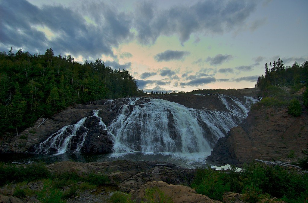
About High Falls
High Falls is a scenic waterfall located a few miles outside of Wawa, Ontario (approximately 4.2 miles from town). The falls sit on a local river/stream draining toward the Lake Superior basin and are a popular short-stop for visitors to the Wawa area. Exact on-site facilities are minimal; viewpoints are generally natural (rock/soil) rather than developed. Seasonal flow varies, with highest water in spring runoff and lower flows in late summer. Winter creates dramatic ice formations but can make access hazardous.
The Setting
High Falls sits at 251 metres in the foothills of Ontario. The falls drop 23 metres.
Why This Waterfall Exists
High Falls flows over hard volcanic rock, primarily basalt and iron formation, laid down over 2.5-3.2 billion years ago. These resistant rocks form a durable ledge that water cannot easily wear away, creating a 75-foot drop where softer material downstream has already eroded.
Trail & Hike Details
The Approach
No hiking required. High Falls is accessible by vehicle with a roadside viewing area.
Trail Description
Expect a short, generally easy walk from the parking/pullout to a natural viewing area. The path may be a foot-trail over uneven or rocky ground and can be steep or slippery near the water's edge. There are likely no boardwalks or railings; viewpoints are natural rock ledges or cleared areas. Trail length and elevation gain appear to be short/low but are not documented precisely here.
What to Expect
The falls drop 23 metres over hard volcanic rock.
Accessibility
This waterfall is viewable from a vehicle-accessible area. No hiking is required.
Frequently Asked Questions
🐶 Are Dogs Allowed at High Falls?
❌ Dogs are not allowed
Are There Any Fees or Permits Required?
🆖 No fees required
🏊 Is There Swimming at High Falls?
❌ Swimming is not allowed
When to Visit
Spring (high flows and full falls) and fall (color and cooler temperatures) are excellent for photography. Summer offers easier travel and warm weather but can mean lower flows. Winter provides ice formations but presents increased hazards and likely requires winter hiking/traction gear.
Seasonal Access
The best time to visit is Spring, Summer, Fall, and Winter. Check with the managing park or local authority for current conditions.
Safety Information
Primary hazards include slippery and unstable rocks near the falls, steep drop-offs without railings, unpredictable water flow (especially after heavy rain), cold water temperatures, and winter ice. Cell service may be limited, plan accordingly. Wildlife encounters (including bears and moose) are possible; carry bear deterrents if appropriate and know how to respond. Always stay on stable ground, supervise children closely, and do not approach the edge for photos. If visiting in winter, use appropriate traction devices and be aware of avalanche/ice hazards on exposed slopes.
Know when to go.
Get a free email alert when waterfalls near Wawa hit peak flow. We only send when conditions are worth the trip — no weekly newsletters, no spam.
Weather Forecast
Location & Access
Getting There
From Wawa, travel roughly 4.2 miles along the local roads/Trans-Canada corridor toward the coordinates 47.9601, -84.829. The falls are reached by a short turnout or an informal spur/trail from the highway or a nearby secondary road. Signage and formal trailheads may be minimal or absent, follow local signs where present and use GPS coordinates if available.
Get Directions on Google MapsParking
Parking is likely informal, a roadside pullout or small dirt lot rather than a developed parking lot. Space may be limited and there are typically no restroom facilities. Park clear of the highway and avoid blocking the shoulder.
Elevation
251 metres above sea level
Coordinates
47.960140° N, -84.828951° W
Visitor Tips & Gear
Wear sturdy, grippy footwear, rocks near the falls are often wet and slippery. Stay back from cliff edges; there may be no railings. Bring insect repellent in spring/summer (black flies and mosquitoes can be abundant). Carry warm layers in shoulder seasons and winter; conditions change quickly. Leave no trace and pack out all trash. Cell service may be spotty; let someone know your plans if you hike beyond the immediate viewpoint.
Where to Stay
Browse vacation cabins and private rentals nearby
Unique outdoor stays — tents, yurts, and treehouses
Rent a campervan or RV for your waterfall road trip
Some links are affiliate links. We may earn a commission at no extra cost to you.
Nearby Campground
Driftwood Beach
5 km away
Additional Information
Nearby Attractions
Town of Wawa (notable roadside attractions such as the Wawa Goose statue), lakeshore and provincial park areas on Lake Superior, other local waterfalls and rivers in the Wawa/Michipicoten region. Exact distances vary; plan additional travel time if visiting multiple sites.
Wildlife
Typical northern Ontario species: black bears, moose, white-tailed deer, beavers, and a variety of songbirds and waterfowl. Exercise standard wildlife precautions: store food securely and give animals space.
Cities near High Falls
Nearby Waterfalls


Other waterfalls named High Falls
31 other waterfalls share this name across Canada.
-
01
Bridgeville
Current flow 133 ft³/s -
02
Copenhagen
Current flow 443 ft³/s -
03
Cranberry Lake
Current flow 185 ft³/s -
04
Grahamsville
Current flow 6 ft³/s -
05
Lake Placid
Current flow 1 ft³/s -
06
Lyon Mountain
Current flow 77 ft³/s -
07
Lyon Mountain
-
08
Philmont
Current flow 83 ft³/s -
09
Prospect
Current flow 7 ft³/s -
10
Rochester
Current flow 3,460 ft³/s -
11
St. Regis Falls
Current flow 149 ft³/s
Writing about High Falls? Embed this waterfall on your site for free.