Difficulty
Moderate
Trail Length
3.2 km
Trail Type
Loop
Elevation Gain
79 m
About Hell's Gate
Hell's Gate is a narrow gorge/rapids feature on a river in the New Liskeard / Cobalt region of northeastern Ontario (coordinates ~47.7972, -79.8998). Locally it is known for rocky channeling of fast water, exposed bedrock and scenic viewpoints. Specifics about height and formal designation are not well documented publicly; access is typically informal and may involve short walks from a road or parking pullout. Visitors should expect a rugged natural setting rather than developed park infrastructure.
The Setting
Hell's Gate sits at 232 metres within Kap-Kig-Iwan Provincial Park, in the foothills of Ontario.
Why This Waterfall Exists
Hell's Gate flows over hard volcanic rock, primarily basalt and iron formation, laid down over 2.5-3.2 billion years ago. These resistant rocks form a durable ledge that water cannot easily wear away, creating the falls where softer material downstream has already eroded.
Nearby Falls Worth Visiting
80 foot waterfall (24 m) lies 11.7 kilometres to the north. Also nearby: High Falls (12 m, 1.0 km).
Trail & Hike Details
The Approach
The moderate 3.2-km loop trail gains 79 metres of elevation on the way to the falls.
Trail Description
There may be a short, informal trail or beaten path from a parking pullout to vantage points above the gorge and rapids. Expect uneven, rocky terrain and possibly steep scrambles to get closer to water. Trails (if present) are likely unmaintained and may be obscured by vegetation in summer. Signage and handrails are unlikely.
What to Expect
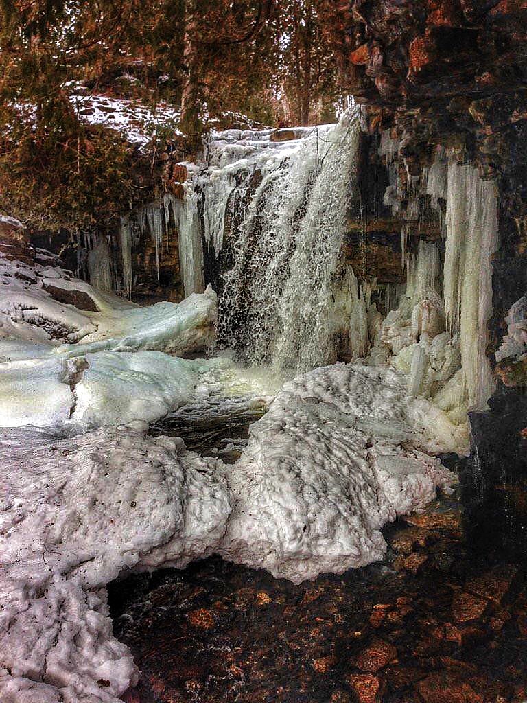
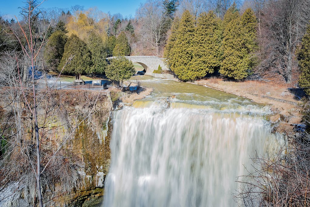
Rocky river channel with rapids and possibly a narrow gorge. Exposed bedrock, wet and slippery surfaces near the water, and limited developed infrastructure. In spring the flow is typically highest and most dramatic; summer may have lower flows but lush vegetation and insects. Winter can produce significant ice formations but also hazardous unstable ice and snow-covered rock.
Accessibility
The trail is not wheelchair accessible. Uneven terrain and elevation changes require steady footing.
Frequently Asked Questions
🐶 Are Dogs Allowed at Hell's Gate?
❌ Dogs are not allowed
Are There Any Fees or Permits Required?
🆖 No fees required
🏊 Is There Swimming at Hell's Gate?
❌ Swimming is not allowed
When to Visit
Spring (high flows) and early summer for dramatic water levels and lush surroundings; fall for cooler temperatures and fall color. Winter offers ice scenery but higher hazards, only experienced winter hikers should attempt.
Seasonal Access
The best time to visit is Spring, Summer, Fall, and Winter. Check with Kap-Kig-Iwan Provincial Park for current conditions.
Safety Information
Hazards include slippery wet rock, steep or unstable edges, swift currents, cold water and hypothermia risk, falling, unstable ice in winter, and limited emergency access/cell coverage. Always stay back from cliff edges, avoid approaching the waterline on wet rock, supervise children and pets closely, and do not attempt to cross fast water. If weather is poor or temperatures are low, postpone the visit.
7-Day Flow Outlook
Based on the WSC gauge BLANCHE RIVER ABOVE ENGLEHART (10 km away).
Best time of year: this gauge typically runs highest from early April to mid June, peaking in May.
How we calculate this
This is a transparent outlook, not a precise forecast. We take the waterfall's current flow strength (how it ranks against its historical normal for today, from the nearest WSC stream gauge), carry that ranking forward along the gauge's seasonal curve, and nudge it for forecast rain. Confidence is highest for the next day or two and falls further out. Always check official conditions and your own judgment before visiting — high flows can be dangerous.
Know when to go.
Get a free email alert when waterfalls near New Liskeard hit peak flow. We only send when conditions are worth the trip — no weekly newsletters, no spam.
Weather Forecast
Location & Access
Getting There
General location: 47.7972, -79.8998. Approximate distances: New Liskeard ~24.4 miles, Cobalt ~29.4 miles, Rouyn‑Noranda ~59.5 miles. Access is commonly by car on local secondary roads; the site may be reached from the nearest paved highways with a short drive on gravel or forest roads. There may be a roadside pullout or small parking area near the river; exact turnoffs and public access points are not consistently signed. Carry a map or GPS and allow for limited cell coverage.
Get Directions on Google MapsParking
Parking is likely limited to roadside pullouts or small informal lots. Expect unpaved surfaces and minimal facilities; large vehicles or trailers may have difficulty. Confirm local signage and avoid parking where it blocks road access.
Elevation
232 metres above sea level
Coordinates
47.797185° N, -79.899848° W
Land Management
Managed by Ontario Parks
Visitor Tips & Gear
• Wear sturdy, closed-toe footwear with good traction. • Use caution on wet or icy rock; do not stand directly on fast-flowing water’s edge. • Expect limited or no cell coverage, bring offline maps or GPS coordinates. • Pack out what you bring in and respect any posted private property or no‑trespass signs. • Watch for insects (mosquitoes and black flies) in warm months and ticks in brush. • Let someone know your plans when exploring remote areas.
As an Amazon Associate, we earn from qualifying purchases.
With 3.2 km and 79 m of elevation gain, sturdy boots and trekking poles will help on this moderate trail. Icy conditions are common in winter — traction cleats are a smart addition.

Columbia Watertight II Rain Jacket
Packs into its own pocket, seam-sealed, and keeps you dry from spray and surprise rain.

Earth Pak Waterproof Dry Bag
Keeps your phone and gear dry when waterfall mist soaks everything else.

Waterproof Phone Pouch (AiRunTech)
Cheap insurance — take photos right next to the falls without killing your phone.

Timberland Euro Sprint Mid Waterproof
Trusted waterproof boot with premium leather and grippy rubber sole — reliable on rocky, wet trails.

TrailBuddy Trekking Poles
Lightweight aluminum, cork grips, and flip-locks that actually hold — a best-seller for good reason.

Kahtoola MICROspikes
Cult-favorite traction cleats that grip ice and wet rock — essential for winter waterfall hikes.
Where to Stay
Browse vacation cabins and private rentals nearby
Unique outdoor stays — tents, yurts, and treehouses
Rent a campervan or RV for your waterfall road trip
Some links are affiliate links. We may earn a commission at no extra cost to you.
Nearby Campground
Kap-Kig-Iwan Park Campground
1.2 km away
Additional Information
Nearby Attractions
Lake Temiskaming and lakeshore areas near New Liskeard/Haileybury; Cobalt Historic Mining District (museums and mining ruins); local provincial forest lands and canoe routes. Rouyn‑Noranda (Quebec) is a regional center with cultural attractions about 60 miles away.
Wildlife
Typical boreal fauna: white‑tailed deer, moose, beaver, black bear, small mammals, and a variety of songbirds and raptors. Expect mosquitoes, black flies and ticks during warmer months.
Cities near Hell's Gate
Nearby Waterfalls
Writing about Hell's Gate? Embed this waterfall on your site for free.