Difficulty
Drive Up
Trail Length
0.2 km
Trail Type
Out And Back
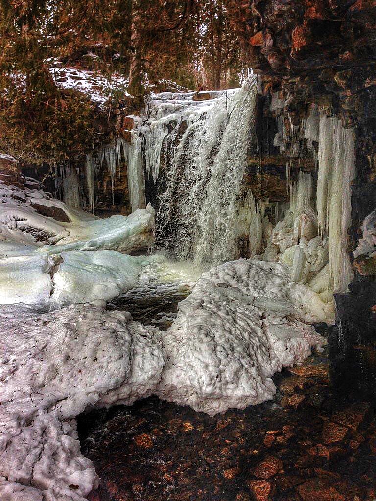
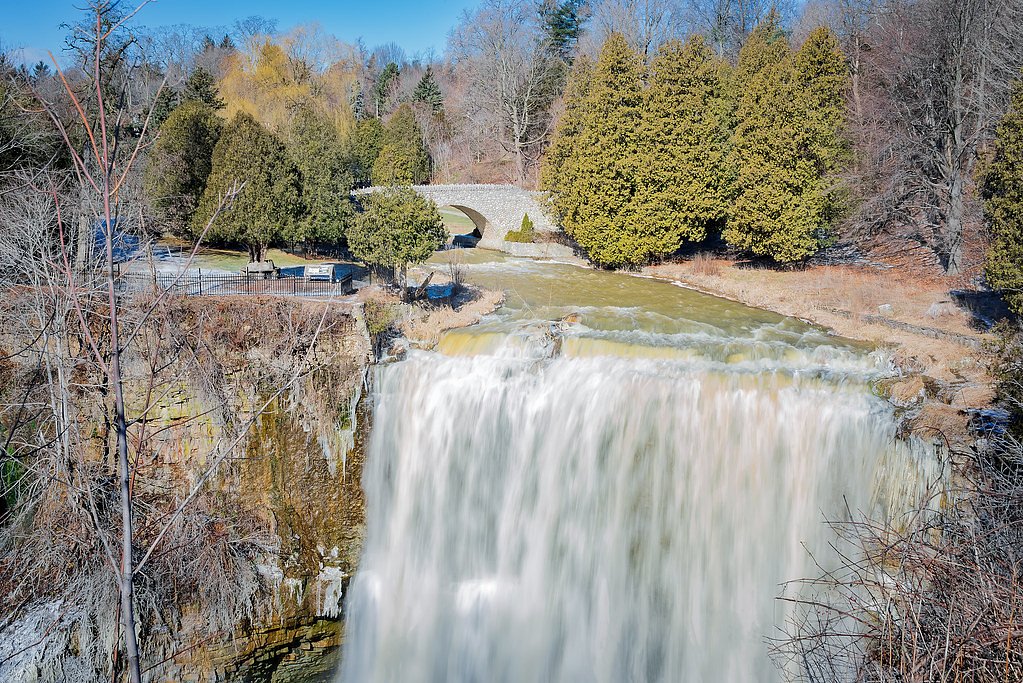
About 80 foot waterfall
An approximately 80-foot waterfall located in the boreal forest near the Ontario–Quebec border. The falls sit in a remote, forested setting and are likely reached by secondary or forestry roads followed by a short hike or scramble to a viewing area. Water volume and access can vary seasonally; spring melt produces the highest flow while winter can produce dramatic ice formations.
The Setting
80 foot waterfall sits at 209 metres in the foothills of Ontario. The falls drop 24 metres.
Why This Waterfall Exists
80 foot waterfall flows over volcanic rock laid down over 2.5-2.8 billion years ago. These resistant rocks form a durable ledge that water cannot easily wear away, creating a 80-foot drop where softer material downstream has already eroded.
Trail & Hike Details
The Approach
No hiking required. 80 foot waterfall is accessible by vehicle with a roadside viewing area.
Trail Description
Trail information for this specific waterfall is limited. Expect an informal trail or scramble from a roadside pullout through mixed boreal forest. Approaches commonly include uneven footing, tree roots, wet rocks, and short steep sections near the falls. There may be little to no signage or maintained boardwalks; route-finding skills could be required.
What to Expect
The falls cascade 24 metres over volcanic rock.
Accessibility
This waterfall is viewable from a vehicle-accessible area. No hiking is required.
Frequently Asked Questions
🐶 Are Dogs Allowed at 80 foot waterfall?
❌ Dogs are not allowed
Are There Any Fees or Permits Required?
🆖 No fees required
🏊 Is There Swimming at 80 foot waterfall?
❌ Swimming is not allowed
When to Visit
Late spring for highest flows and dramatic water volume. Early summer offers milder weather but increased insects. Fall for foliage and lower visitor numbers. Winter can be spectacular for ice formations but requires winter skills and traction devices.
Seasonal Access
The best time to visit is Spring, Summer, Fall, and Winter. Check with the managing park or local authority for current conditions.
Safety Information
Hazards include slippery and unstable rocks near the falls, steep dropoffs, strong currents, sudden weather changes, limited cell coverage, and seasonal ice. Watch footing, stay back from cliff edges, supervise children closely, and do not climb on wet rocks. In winter use appropriate traction and clothing and be aware of avalanche or ice‑fall risks on steep slopes. If visiting remote areas, inform someone of your plans and expected return time.
7-Day Flow Outlook
Based on the WSC gauge BLANCHE RIVER ABOVE ENGLEHART (1 km away).
Best time of year: this gauge typically runs highest from early April to mid June, peaking in May.
How we calculate this
This is a transparent outlook, not a precise forecast. We take the waterfall's current flow strength (how it ranks against its historical normal for today, from the nearest WSC stream gauge), carry that ranking forward along the gauge's seasonal curve, and nudge it for forecast rain. Confidence is highest for the next day or two and falls further out. Always check official conditions and your own judgment before visiting — high flows can be dangerous.
Know when to go.
Get a free email alert when waterfalls near New Liskeard hit peak flow. We only send when conditions are worth the trip — no weekly newsletters, no spam.
Weather Forecast
Location & Access
Getting There
Coordinates: 47.9016, -79.8741. Nearest towns (approx.): New Liskeard ~28.4 miles, Cobalt ~33.4 miles, Rouyn‑Noranda ~53.3 miles. Access is likely via paved secondary roads turning onto gravel/forestry roads; final approach may be a short hike or roadside pullout. Expect limited signage and potentially poor cell coverage. Verify current road and trail conditions with local tourism or municipal offices before travel.
Get Directions on Google MapsParking
Parking is likely limited to a small informal pullout or roadside shoulder near the trailhead. There may be no formal lot, vault toilets, or maintained facilities. Park legally and avoid blocking roads; if unsure, plan to park in the nearest town and allow extra time.
Elevation
209 metres above sea level
Coordinates
47.901612° N, -79.874054° W
Visitor Tips & Gear
1) Check local maps and contact nearby town offices or regional tourism for the latest access and road conditions. 2) Wear sturdy, waterproof footwear with good traction; expect slippery rocks and muddy sections. 3) Bring insect repellent in spring/summer and traction devices (microspikes) in winter. 4) Park legally and leave no trace, pack out all waste. 5) Tell someone your plans and expected return time due to remoteness.
Where to Stay
Browse vacation cabins and private rentals nearby
Unique outdoor stays — tents, yurts, and treehouses
Rent a campervan or RV for your waterfall road trip
Some links are affiliate links. We may earn a commission at no extra cost to you.
Nearby Campground
Kap-Kig-Iwan Park Campground
11.3 km away
Additional Information
Nearby Attractions
Nearby towns: New Liskeard (~28.4 miles), Cobalt (~33.4 miles), Rouyn‑Noranda (~53.3 miles). The region offers lakes, canoeing, fishing and other backcountry recreational opportunities, check local tourism offices for named parks and provincial recreation areas.
Wildlife
Typical boreal wildlife may include moose, black bear, white‑tailed deer, beaver, otter and a variety of birds. Expect insects such as black flies and mosquitoes in warmer months. Practice wildlife safety: store food securely and give large animals space.
Cities near 80 foot waterfall
Nearby Waterfalls
Writing about 80 foot waterfall? Embed this waterfall on your site for free.