
Photo Credits (1)
About Doré Falls
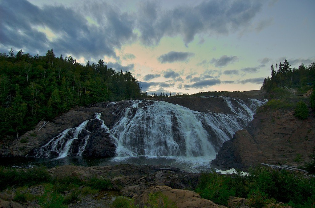
Doré Falls is a small to medium-sized cascade on the Canadian Shield near Wawa, Ontario (coordinates provided). The falls sit in a rugged, forested landscape of exposed bedrock and mixed boreal forest and appear as a series of drops/cascades rather than a single tall plunge. Water flow is highly seasonal, typically highest in spring runoff and after heavy rains, and lower in late summer. Specific height and official park classification are not well-documented in widely available park databases, and visitors commonly report informal/unmarked access off nearby forestry or service roads.
The Setting
Doré Falls sits at 197 metres in the foothills of Ontario. The falls drop 1 metres.
Why This Waterfall Exists
Doré Falls flows over hard light volcanic rock laid down over 2.5-2.8 billion years ago. These resistant rocks form a durable ledge that water cannot easily wear away, creating a 3-foot drop where softer material downstream has already eroded.
Trail & Hike Details
Trail Description
There is no widely published maintained trail to Doré Falls. Access reported by visitors tends to be via informal footpaths, a short bushwhack from a forestry road pullout, or along rocky shorelines. Expect uneven terrain, exposed bedrock, roots, and sections that can be wet and slippery. Trail navigation may require map/GPS and basic route-finding skills. Because routes are informal, conditions and exact approach can vary and change with seasons and maintenance.
What to Expect
The falls drop a gentle 1 metres over layered sedimentary rock.
Accessibility
Access is likely primitive and not wheelchair or stroller accessible. Expect uneven, rocky, and potentially steep sections near the falls. Not recommended for visitors needing accessible trails.
Frequently Asked Questions
🐶 Are Dogs Allowed at Doré Falls?
❌ Dogs are not allowed
Are There Any Fees or Permits Required?
🆖 No fees required
🏊 Is There Swimming at Doré Falls?
❌ Swimming is not allowed
When to Visit
Spring (late April–June) for highest flows and dramatic cascades; summer for easier travel on gravel roads and warmer weather; fall for foliage color and lower visitor numbers. Winter can offer dramatic ice formations but may require snowshoes, snowmobile access, or winter driving experience and increases risk from cold and limited access.
Seasonal Access
The best time to visit is Spring, Summer, Fall, and Winter. Check with the managing park or local authority for current conditions.
Safety Information
Hazards include slippery and unstable rocks near the water, fast currents, cold water temperatures, sudden drops, and limited or no cell service. Forestry and secondary roads may be rough or seasonally impassable; high-clearance or 4x4 vehicles may be required. Weather can change quickly. If visiting in bear country, carry bear awareness supplies and follow local guidance. If you are uncertain about route conditions, consult local authorities or recent visitor trip reports before going.
Know when to go.
Get a free email alert when waterfalls near Wawa hit peak flow. We only send when conditions are worth the trip — no weekly newsletters, no spam.
Weather Forecast
Location & Access
Getting There
Doré Falls is located roughly 9.5 miles (about 15 km) from the town of Wawa (per the supplied location context). Access typically requires driving on paved highway to the nearest logging/forestry road or pullout and then a short unmarked walk. Exact trailhead locations are informal and may not be signed; a GPS with the provided coordinates, recent visitor trip reports, or local advice from Wawa area sources is recommended. Expect unpaved roads, possible washouts, and seasonal closures of secondary roads.
Get Directions on Google MapsParking
There is likely no formal parking lot. Visitors typically park at a roadside pullout or small informal parking area near the forestry road. Use caution when parking on narrow shoulders and avoid blocking gates or access roads. Availability may be limited.
Elevation
197 metres above sea level
Coordinates
47.963111° N, -84.957798° W
Visitor Tips & Gear
1) Use the provided coordinates and an offline map or GPS; don’t rely solely on cellphone reception. 2) Wear sturdy hiking shoes with good traction for wet rock and roots. 3) Treat water as cold and potentially fast-moving, do not assume safe swimming. 4) Be prepared for insects (black flies, mosquitoes) in spring/summer. 5) Respect private property, stop and ask permission if access appears to cross private land. 6) Let someone know your plans; remote roads and trails may be poorly maintained. 7) Bring a small pack to carry out any trash; there are no facilities.
Where to Stay
Browse vacation cabins and private rentals nearby
Unique outdoor stays — tents, yurts, and treehouses
Rent a campervan or RV for your waterfall road trip
Some links are affiliate links. We may earn a commission at no extra cost to you.
Nearby Campground
Smoky Point
10.4 km away
Additional Information
Nearby Attractions
The town of Wawa (services, groceries, gas) and scenic Lake Superior shorelines are the nearest notable visitor services and attractions. Wawa's town center, shoreline parks, and regional scenic drives provide additional activities. Check local visitor information in Wawa for current suggestions.
Wildlife
Typical boreal species may be present: black bear, moose, white-tailed deer, foxes, small mammals, and a variety of birds. Ticks, black flies and mosquitoes can be locally abundant in warm months. Practice standard wildlife safety and store food securely.
Cities near Doré Falls
Nearby Waterfalls

Writing about Doré Falls? Embed this waterfall on your site for free.