Photo Credits (2)
Difficulty
Drive Up
Trail Length
0.2 km
Trail Type
Out And Back
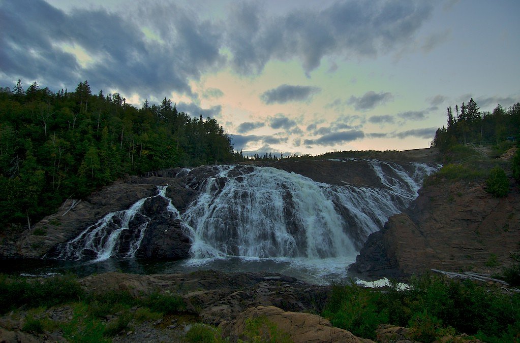
About Lower Silver Falls
Lower Silver Falls is a small, forested waterfall site located near Wawa, Ontario (approx. 5.3 miles from Wawa town center; coordinates 47.9386, -84.8298). The falls sit in a rugged, boreal-forest setting and are typically accessed by a short forest trail or service road. Flow and appearance vary seasonally, with highest flow in spring and after heavy rains. Specifics about official park designation and published height are not confidently known and are presented conservatively below.
Why This Waterfall Exists
Lower Silver Falls flows over hard volcanic rock, primarily basalt and iron formation, laid down over 2.5-3.2 billion years ago. These resistant rocks form a durable ledge that water cannot easily wear away, creating the falls where softer material downstream has already eroded.
Nearby Falls Worth Visiting
High Falls (23 m) lies 2.4 kilometres to the north. Also nearby: Doré Falls (1 m, 10.0 km).
Trail & Hike Details
The Approach
No hiking required. Lower Silver Falls is accessible by vehicle with a roadside viewing area.
Trail Description
Access is reported as a short walk from a roadside parking or turnout through mixed boreal forest to the creek and falls. Trail may be informal, narrow, and uneven with roots and rocks; sections can be muddy. There may be a short scramble to view the base or crest of the falls. Trails and access infrastructure do not appear to be developed to a park-standard boardwalk or viewing platform.
What to Expect
A relatively small, likely multi-step cascade or drop in a forested setting. Expect natural, undeveloped surroundings: conifer and mixed hardwood forest, moss-covered rocks, and a creek channel. Flow varies seasonally, high in spring melt and after rains, lower in late summer or drought. Limited signage, amenities, and facilities; expect primitive conditions.
Accessibility
This waterfall is viewable from a vehicle-accessible area. No hiking is required.
Frequently Asked Questions
🐶 Are Dogs Allowed at Lower Silver Falls?
❌ Dogs are not allowed
Are There Any Fees or Permits Required?
🆖 No fees required
🏊 Is There Swimming at Lower Silver Falls?
❌ Swimming is not allowed
When to Visit
Late spring (peak runoff) for best flow, and early fall for foliage and cooler conditions. Summer offers easier trail conditions but lower flows. Winter can create scenic ice formations but brings greater access hazards (snow, ice) and may require snowshoes or traction devices.
Seasonal Access
The best time to visit is Spring, Summer, Fall, and Winter. Check with the managing park or local authority for current conditions.
Safety Information
Hazards include slippery and unstable rocks near the falls, fast or cold water, steep or poorly defined trail sections, seasonal flooding, ticks, black flies and mosquitoes, and potential encounters with large wildlife (black bears, moose). Cell service may be unreliable; carry navigation and emergency supplies. Do not climb on wet rocks or attempt to swim near the falls without local knowledge, currents and undercut rocks can be dangerous. Use extra caution in winter due to ice and deep snow. If unsure of conditions, seek recent trip reports or local authority guidance before visiting.
Know when to go.
Get a free email alert when waterfalls near Wawa hit peak flow. We only send when conditions are worth the trip — no weekly newsletters, no spam.
Weather Forecast
Location & Access
Getting There
From Wawa, follow local secondary roads toward the Silver Falls area (approx. 5–6 miles). Exact vehicle routes and signage may be limited; a high-clearance vehicle may be helpful on unpaved access roads. Use the provided coordinates (47.9386, -84.8298) for navigation. Expect limited or no cell service in parts of the route.
Get Directions on Google MapsParking
There may be an informal parking/turnout near the trailhead or roadside pullout. Parking is likely unpaved and minimal; do not block gates or driveways. Confirm local access rules before driving on land managed by private owners.
Elevation
195 metres above sea level
Coordinates
47.938631° N, -84.829750° W
Visitor Tips & Gear
Bring sturdy footwear for wet, uneven terrain. Use insect repellent in spring/summer; black flies and mosquitoes can be heavy. Expect limited to no facilities (toilets, trash bins). Leave no trace: pack out what you pack in. Verify land access and any seasonal road conditions before visiting. Check recent trip reports or local resources for the latest trail and parking info.
Where to Stay
Browse vacation cabins and private rentals nearby
Unique outdoor stays — tents, yurts, and treehouses
Rent a campervan or RV for your waterfall road trip
Some links are affiliate links. We may earn a commission at no extra cost to you.
Nearby Campground
Driftwood Beach
2.6 km away
Additional Information
Nearby Attractions
Town of Wawa (services, accommodations), Lake Superior shoreline and related viewpoints, local hiking routes and backcountry opportunities. For more established attractions, consult Wawa tourism resources or regional park information.
Wildlife
Typical boreal wildlife may be present: white-tailed deer, moose, black bear, beavers, various birds and small mammals. Exercise standard wildlife precautions (store food properly, keep distance).
Cities near Lower Silver Falls
Nearby Waterfalls

Writing about Lower Silver Falls? Embed this waterfall on your site for free.