Photo Credits (5)
Difficulty
Moderate
Trail Length
2.0 miles
Trail Type
Out And Back
Elevation Gain
300 ft
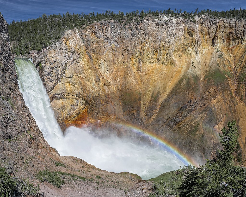
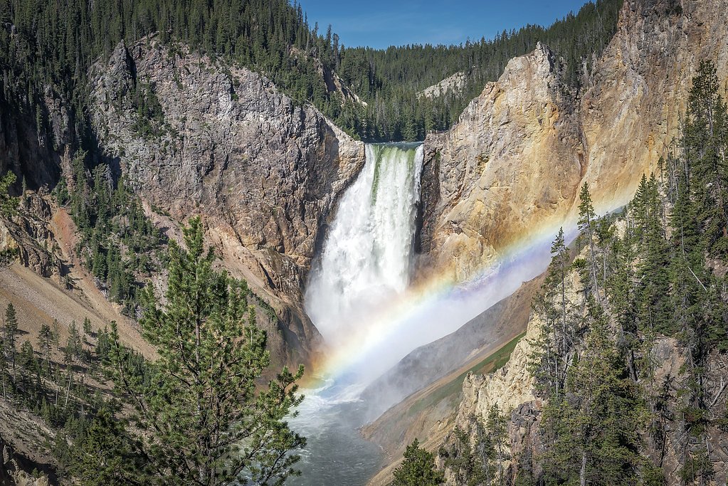
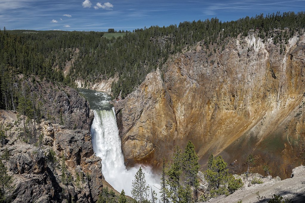
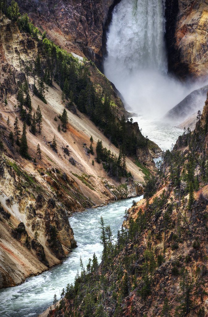
About Cascade Falls
Cascade Falls is a woodland cascade tucked inside Lolo National Forest and managed by the U.S. Forest Service. The waterfall’s quiet setting—framed by mature forest—makes it a popular short destination for day hikers and photographers looking for an easy dose of Montana’s natural beauty. The official USFS viewpoint trail, OVERLOOK AT CASCADE FALLS (Trail #242-A), brings visitors to a compact overlook where the falls can be enjoyed up close. The walk to the falls is approachable but rewarding: the commonly used route is a moderate 2.0-mile out-and-back with about 300 feet of elevation gain, making it suitable for most hikers who are comfortable with some uphill walking. If you’d like to stay nearby, Cascade Campground sits just 0.39 km from the trailhead, offering an easy option for overnight camping and early- or late-day visits to avoid crowds.
The Setting
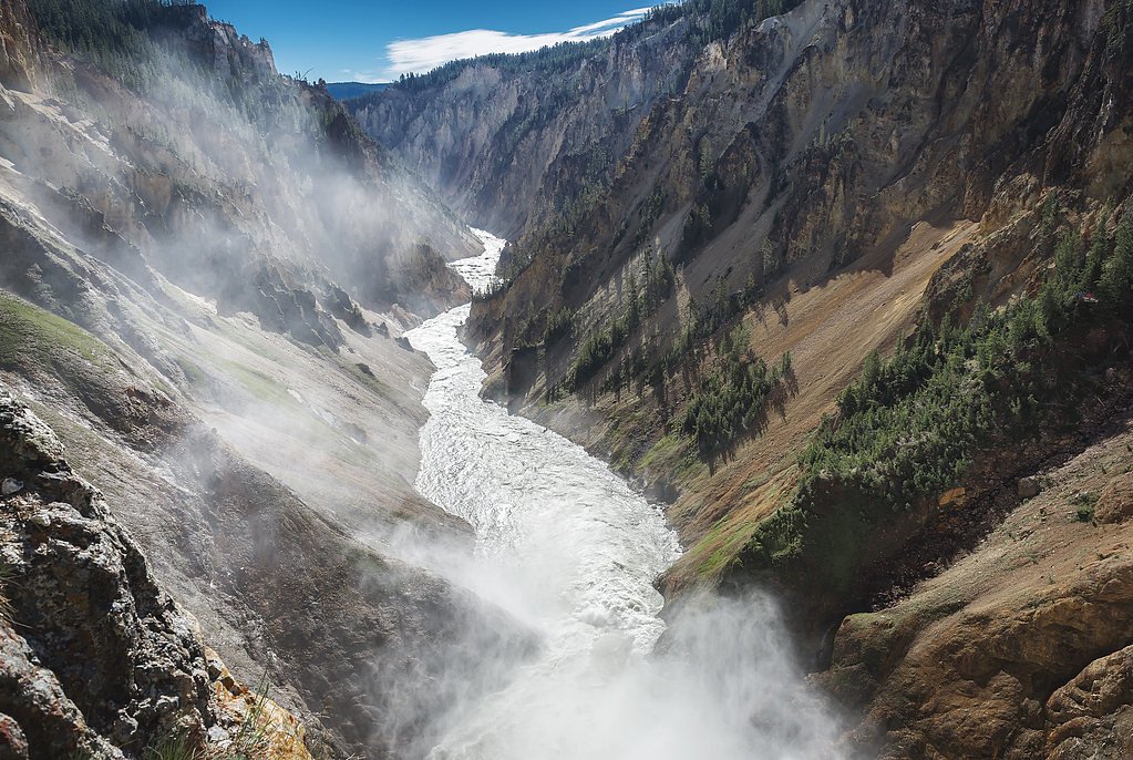
Cascade Falls sits at 3,005 feet within Lolo National Forest, fed by the Clark Fork, in the mountains of Montana.
Trail & Hike Details
The Approach
The moderate hike follows Overlook At Cascade Falls (#242-A), a 2.0-mile out-and-back trail over natural surface. Expect 300 feet of elevation gain with grades of 12-20%. The trail is developed (Class 3).
USFS Trail
OVERLOOK AT CASCADE FALLS #242-A
Trail Class
Developed
Surface
Avg Grade
USFS Segment
0.09 miTrail Description
The officially mapped USFS segment to the viewing area is OVERLOOK AT CASCADE FALLS, Trail #242-A. That segment is recorded as Class 3 with a NATIVE MATERIAL surface, a typical grade of 12–20%, and a GIS length of 0.09 miles — in other words, a short, steeper native-tread approach to the overlook. The full outing to Cascade Falls is typically done as a 2.0-mile out-and-back with about 300 feet of elevation gain and is rated moderate. Expect native trail tread and short, steep sections per the USFS data; sturdy footwear and standard hiking precautions are recommended.
What to Expect
Dogs are welcome.
Accessibility
The trail is not wheelchair accessible. Uneven terrain and elevation changes require steady footing.
Frequently Asked Questions
🐶 Are Dogs Allowed at Cascade Falls?
✅ Dogs are allowed
Are There Any Fees or Permits Required?
🆖 No fees required
🏊 Is There Swimming at Cascade Falls?
❌ Swimming is not allowed
When to Visit
Spring and early summer are ideal times to visit, as the waterfall is usually at its fullest due to snowmelt. Fall offers beautiful foliage, while summer provides warmer weather for hiking.
Seasonal Access
The best time to visit is Spring, Summer, and Fall. Winter access may be limited. Check with Lolo National Forest for seasonal road closures.
Safety Information
Be cautious of slippery rocks near the waterfall, especially after rain. Watch for wildlife and carry bear spray if hiking in bear country. Always stay on marked trails.
Current Water Conditions
31,000 ft³/s
Current discharge — how much water is flowing
About average for this time of year
Based on 115 years of record
8.37 ft
Water depth at gauge
7-Day Discharge Trend
What does this mean for your visit?
Flow is about average for this time of year.
About This Gauge
This gauge is on a nearby waterway and may not reflect exact conditions at the falls.
7-Day Flow Outlook
Based on the USGS gauge Clark Fork near Plains MT (14 km away).
Today
Roaring
33372 cfs
6/10Tomorrow
Roaring
33689 cfs
6/10Wed
Roaring
34877 cfs
6/10Thu
Roaring
31415 cfs
6/10Fri
Roaring
26858 cfs
9/10Sat
Roaring
26601 cfs
6/10Sun
Roaring
25150 cfs
9/10Best window: Fri — roaring flow, mostly sunny (trip score 9/10).
Best time of year: this gauge typically runs highest from mid April to mid July, peaking in June.
How we calculate this
This is a transparent outlook, not a precise forecast. We take the waterfall's current flow strength (how it ranks against its historical normal for today, from the nearest USGS stream gauge), carry that ranking forward along the gauge's seasonal curve, and nudge it for forecast rain. Confidence is highest for the next day or two and falls further out. Always check official conditions and your own judgment before visiting — high flows can be dangerous.
Know when to go.
Get a free email alert when waterfalls near Paradise hit peak flow. We only send when conditions are worth the trip — no weekly newsletters, no spam.
Weather Forecast
Location & Access
Getting There
Cascade Falls is located near the town of Cascade, Montana. Access typically involves driving to a trailhead, with the exact route depending on your starting location. Check local maps or GPS for the most accurate directions.
Get Directions on Google MapsParking
Parking is available near the trailhead, but spaces may be limited during peak seasons.
Elevation
3,005 feet above sea level
Coordinates
47.302079° N, -114.826396° W
Land Management
Managed by USFS
Visitor Tips & Gear
Start your hike early in the day to avoid crowds and ensure you have enough daylight for the return trip. Bring plenty of water and wear appropriate footwear for uneven terrain.
As an Amazon Associate, we earn from qualifying purchases.
With 2.0 miles and 300 ft of elevation gain, sturdy boots and trekking poles will help on this moderate trail. Sun exposure on the trail makes good sun protection a must in summer.

Polarized Sunglasses (Knockaround)
Cuts glare off the water so you actually see the falls — and your photos turn out better too.

Columbia Watertight II Rain Jacket
Packs into its own pocket, seam-sealed, and keeps you dry from spray and surprise rain.

Earth Pak Waterproof Dry Bag
Keeps your phone and gear dry when waterfall mist soaks everything else.

Waterproof Phone Pouch (AiRunTech)
Cheap insurance — take photos right next to the falls without killing your phone.

Timberland Euro Sprint Mid Waterproof
Trusted waterproof boot with premium leather and grippy rubber sole — reliable on rocky, wet trails.

TrailBuddy Trekking Poles
Lightweight aluminum, cork grips, and flip-locks that actually hold — a best-seller for good reason.
Where to Stay

Rocky Point Ranch, Montana

Stunning A-Frame Cabin, Steps to Clark Fork River

Big Sky Motel

Little River Motel Saint Regis
Browse vacation cabins and private rentals nearby
Unique outdoor stays — tents, yurts, and treehouses
Rent a campervan or RV for your waterfall road trip
Some links are affiliate links. We may earn a commission at no extra cost to you.
Nearby Campground
Cascade Campground
0.2 miles away · 2 sites
Overview Scenic BywayClark Fork RiverIron Mountain TrailheadCascade FallsWildlifeDouglas-fir, ponderosa pine, and western larch treesRecreation CampingHikingFishingRaftingBoatingFacilities Cascade Campground has 11 sites plus 1 group site that are back in only and can accommodate RV's 27' to 35' in length depending on the site. All sites have a picnic table and a fire ring. A primitive boat ramp is available on Clark Fork River across the highway from the campground. Potable water, vault toilets
Book on Recreation.govNearby Hot Springs
Hot springs near Paradise, Montana
Quinns Hot Springs
Quinns Hot Springs flows at 109 degrees Fahrenheit in the Clark Fork River valley of Sanders County, Montana, at a low elevatio...
Green Springs
Green Springs flows at 79°F on the Flathead Reservation in Sanders County, Montana, at 2,813 feet — one of the lower-elevation ...
Camas Hot Springs
Camas Hot Springs flows at 113°F on the Flathead Reservation in western Montana, managed as tribal land with restricted or unkn...
Wild Horse Hot Springs
Wild Horse Hot Springs sits on the Flathead Reservation in Sanders County, Montana, near Plains, at 2,756 feet, one of the lowe...

Lolo Hot Springs, Granite Springs
Lolo Hot Springs registers 111°F with unusually alkaline water at pH 9.3 and very low mineral content, dominated by 52 mg/L sod...
Looking for a soak after your hike? Explore more hot springs near Paradise, Montana on SoakingSprings.
Explore Montana springsAdditional Information
Nearby Attractions
The town of Cascade offers small-town charm and amenities. Nearby, you can explore other hiking trails and scenic spots in the area.
Wildlife
The area is home to various wildlife, including deer, birds, and small mammals. Be cautious and respectful of the natural habitat.
Cities near Cascade Falls
Other waterfalls named Cascade Falls
24 other waterfalls share this name across the U.S.
Writing about Cascade Falls? Embed this waterfall on your site for free.