Photo Credits (5)
Difficulty
Moderate
Trail Length
2.4 miles
Trail Type
Out And Back
Elevation Gain
350 ft
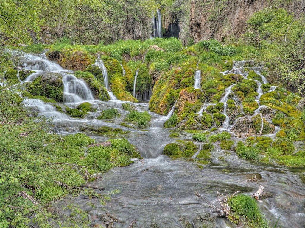
About Cascade Falls
Cascade Falls is a small, picturesque waterfall just outside Hot Springs, South Dakota, tucked into the Ponderosa pines of the Black Hills National Forest. Managed by the U.S. Forest Service, the falls are a favorite quick outing for locals and visitors alike; the clear water and the intimate cascade make for great photos and a refreshing stop during a Black Hills loop. The site is commonly associated with Cascade Creek and is known locally for its scenic charm and historic ties to the area. Access to the falls is via the U.S. Forest Service’s J.H. Keith Trail (Trail #103L). While the maintained J.H. Keith segment is very short, many hikers combine that approach with nearby forest routes to create a longer outing. The setting feels tucked away but is easy to reach from Hot Springs, offering an inviting short hike or a pleasant detour on a day of exploring the Black Hills National Forest.
The Setting
Cascade Falls sits at 3,268 feet within Black Hills National Forest, fed by the Hat Creek, in the mountains of South Dakota.
Trail & Hike Details
The Approach
The moderate hike follows J.H. Keith Trail (#103L), a 2.4-mile out-and-back trail over imported compacted material. Expect 350 feet of elevation gain with grades of 0-5%. The trail is highly developed (Class 4).
USFS Trail
J.H. KEITH TRAIL #103L
Trail Class
Highly Developed
Surface
Avg Grade
USFS Segment
0.13 miTrail Description
The official USFS approach is the J.H. Keith Trail (Trail #103L). USFS records show a GIS length of 0.13 miles for Trail #103L, with an imported compacted material surface, a typical grade of 0–5%, and a Class 4 designation for the maintained segment. Many visitors follow this short maintained section as part of a roughly 2.4-mile out-and-back route (total) that gains about 350 feet and is commonly rated moderate overall. Expect a firm, compacted tread on the maintained portion, some short steeper sections, and easy route-finding to the falls from the trail terminus.
What to Expect
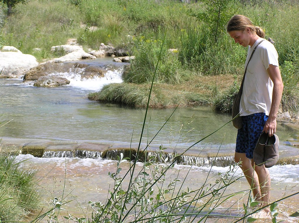
Swimming is permitted. Dogs are welcome.
Accessibility
The trail is not wheelchair accessible. Uneven terrain and elevation changes require steady footing.
Frequently Asked Questions
🐶 Are Dogs Allowed at Cascade Falls?
✅ Dogs are allowed
Are There Any Fees or Permits Required?
🆖 No fees required
🏊 Is There Swimming at Cascade Falls?
✅ Swimming is allowed
When to Visit
Spring and summer are the best times to visit, as the area is lush and the water is most inviting. Fall offers beautiful foliage, while winter may provide a quieter experience.
Seasonal Access
The best time to visit is Spring, Summer, and Fall. Winter access may be limited. Check with Black Hills National Forest for seasonal road closures.
Safety Information
Rocks near the falls can be slippery, so exercise caution when walking or wading. Be mindful of water levels after heavy rain, as the creek may become more hazardous.
Current Water Conditions
0 ft³/s
Current discharge — how much water is flowing
About average for this time of year
Based on 75 years of record
7.06 ft
Water depth at gauge
What does this mean for your visit?
Flow is about average for this time of year.
About This Gauge
This gauge is on a nearby waterway and may not reflect exact conditions at the falls.
7-Day Flow Outlook
Based on the USGS gauge HAT CREEK NEAR EDGEMONT,SD (9 km away).
Best time of year: this gauge typically runs highest from late May to early June, peaking in June.
How we calculate this
This is a transparent outlook, not a precise forecast. We take the waterfall's current flow strength (how it ranks against its historical normal for today, from the nearest USGS stream gauge), carry that ranking forward along the gauge's seasonal curve, and nudge it for forecast rain. Confidence is highest for the next day or two and falls further out. Always check official conditions and your own judgment before visiting — high flows can be dangerous.
Know when to go.
Get a free email alert when waterfalls near Angostura hit peak flow. We only send when conditions are worth the trip — no weekly newsletters, no spam.
Weather Forecast
Location & Access
Getting There
Cascade Falls is located approximately 8 miles south of Hot Springs, South Dakota, along Highway 71. There is a small parking area near the falls, making it easily accessible.
Get Directions on Google MapsParking
A small parking lot is available near the falls, providing convenient access for visitors.
Elevation
3,268 feet above sea level
Coordinates
43.319420° N, -103.563807° W
Land Management
Managed by USFS
Visitor Tips & Gear
Arrive early during summer months to avoid crowds. Bring water shoes if you plan to wade in the creek, as the rocks can be slippery.
As an Amazon Associate, we earn from qualifying purchases.
With 2.4 miles and 350 ft of elevation gain, sturdy boots and trekking poles will help on this moderate trail. Sun exposure on the trail makes good sun protection a must in summer.

Polarized Sunglasses (Knockaround)
Cuts glare off the water so you actually see the falls — and your photos turn out better too.

Columbia Watertight II Rain Jacket
Packs into its own pocket, seam-sealed, and keeps you dry from spray and surprise rain.

Earth Pak Waterproof Dry Bag
Keeps your phone and gear dry when waterfall mist soaks everything else.

Waterproof Phone Pouch (AiRunTech)
Cheap insurance — take photos right next to the falls without killing your phone.

Timberland Euro Sprint Mid Waterproof
Trusted waterproof boot with premium leather and grippy rubber sole — reliable on rocky, wet trails.

TrailBuddy Trekking Poles
Lightweight aluminum, cork grips, and flip-locks that actually hold — a best-seller for good reason.
Where to Stay

5 Mi to Town: Mtn-View Gem w/ Deck in Hot Springs

Hills Inn

River Falls Lodging -Black Hills, South Dakota

Super 8 by Wyndham Hot Springs
Browse vacation cabins and private rentals nearby
Unique outdoor stays — tents, yurts, and treehouses
Rent a campervan or RV for your waterfall road trip
Some links are affiliate links. We may earn a commission at no extra cost to you.
Nearby Campground
Cottonwood Springs Campground
8.3 miles away · 18 sites
Overview Located just 5 miles west of Hot Springs, SD is a hidden gem of a campground. Cottonwood Springs Campground is a quiet, peaceful campground tucked away in the southern part of the Black Hills of South Dakota. It offers beautiful scenic views within a short walk of each campsite. Recreation While Cottonwood Springs Lake is a small lake, it provides a quiet opportunity to wet a line and possibly catch a large mouth bass, rainbow trout, or various pan fish. Canoes, kayaks, paddleboards, or
Book on Recreation.govNearby Hot Springs
Hot springs near Angostura, South Dakota
Hot Brook Springs
Hot Brook Springs flows at 75°F at 3,625 feet elevation near Hot Springs, South Dakota, running 26 degrees above the 49.1°F amb...

Hot Springs
Hot Springs flows at 87°F in downtown Hot Springs, Fall River County, South Dakota, at 3,493 feet elevation, just 88 feet from ...
Looking for a soak after your hike? Explore more hot springs near Angostura, South Dakota on SoakingSprings.
Explore South Dakota springsAdditional Information
Nearby Attractions
Hot Springs, South Dakota; Wind Cave National Park; Mammoth Site of Hot Springs.
Wildlife
The area is home to various bird species, small mammals, and aquatic life in the creek.
Cities near Cascade Falls
Other waterfalls named Cascade Falls
24 other waterfalls share this name across the U.S.
Writing about Cascade Falls? Embed this waterfall on your site for free.