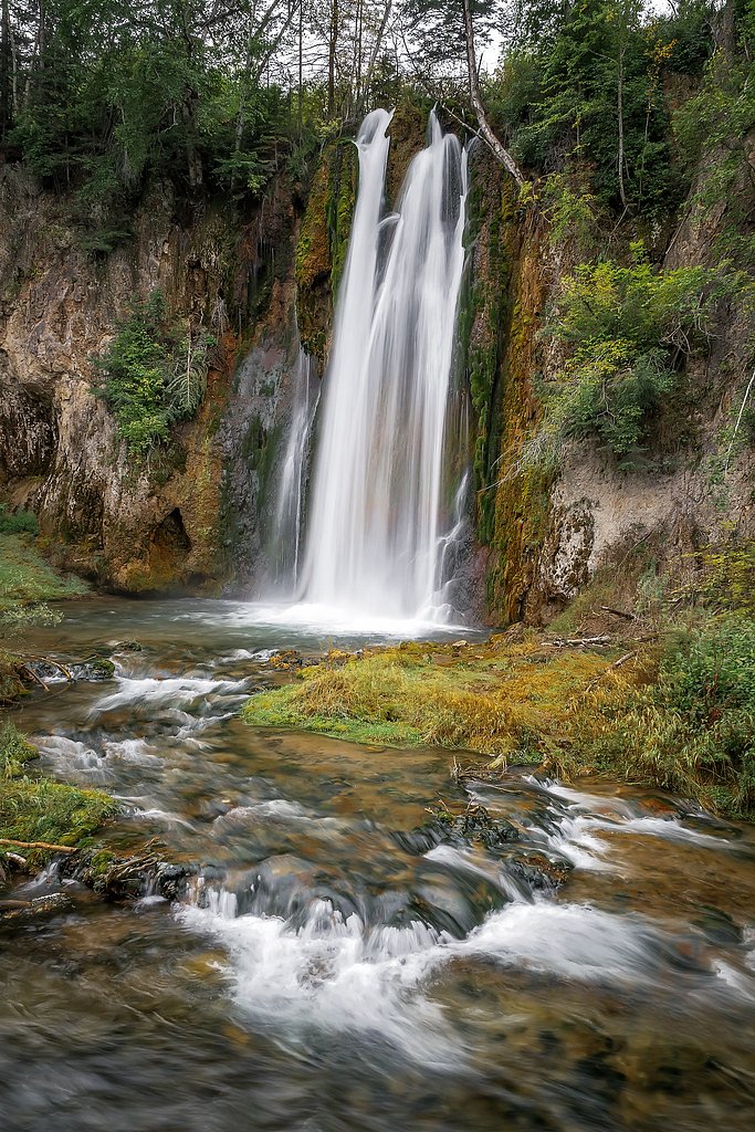
Bridal Veil Falls
By Armen Suny · Last verified Mar 2026
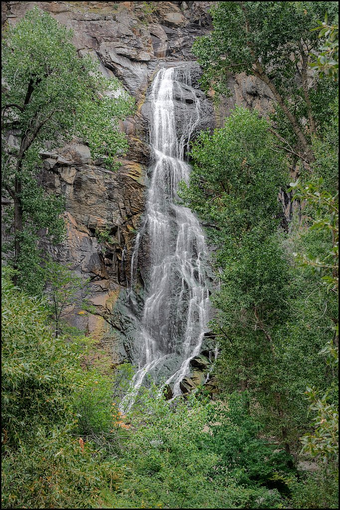
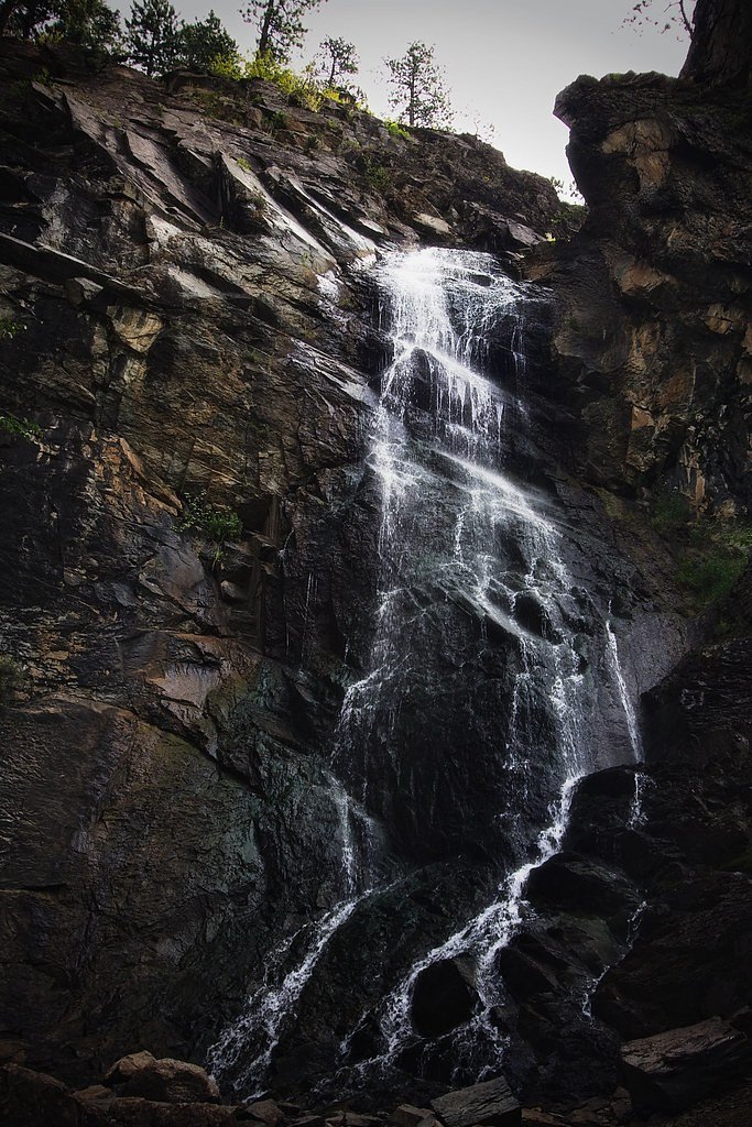
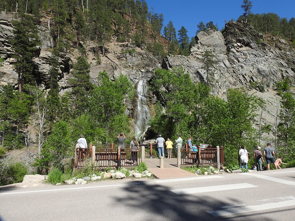


Photo Credits (5)
Difficulty
Moderate
Trail Length
2.4 miles
Trail Type
Out And Back
Elevation Gain
350 ft
About Bridal Veil Falls
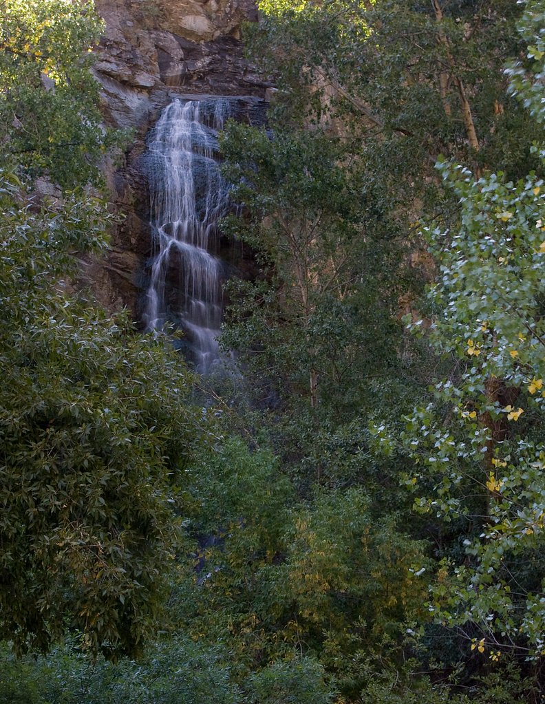
Bridal Veil Falls tumbles through a narrow granite chute in Spearfish Canyon, offering the classic lace-like cascade that makes it one of the canyon's most photographed stops. Easily reached from the road, the falls are managed by the U.S. Forest Service as part of the Black Hills National Forest, so you can enjoy that iconic view with minimal effort—there’s a designated roadside parking area that puts the falls within easy sight for visitors of all abilities. If you want to stretch your legs beyond the overlook, the nearby USFS Big Hill Loop C (Trail #72C) provides a more immersive forest experience. Camping is convenient for multi-day visitors too—the Northern Hills-Spearfish campground lies about 9.48 km away, keeping the canyon’s trails and viewpoints within easy reach for an overnight trip.
The Setting
Bridal Veil Falls sits at 4,203 feet within Black Hills National Forest, fed by the Spearfish Creek, in the mountains of South Dakota.
Nearby Falls Worth Visiting
Spearfish Falls, the tallest waterfall in South Dakota at 47 feet, lies 5.0 miles to the southwest.
Trail & Hike Details
The Approach
The moderate hike follows Big Hill Loop C (#72C), a 2.4-mile out-and-back trail over natural surface. Expect 350 feet of elevation gain with grades of 12-20%. The trail is developed (Class 3).
USFS Trail
BIG HILL LOOP C #72C
Trail Class
Developed
Surface
Avg Grade
USFS Segment
4.35 miTrail Description
No hiking is required to view Bridal Veil Falls; the waterfall is visible from the roadside and accessible from a designated parking area. For hikers seeking a longer route, the U.S. Forest Service lists Big Hill Loop C (Trail #72C) on the Black Hills National Forest. Trail #72C is classified as Class 3, has a native-material (NAT) surface, and typically grades between 12–20%. USFS GIS mapping shows the loop at about 4.35 miles, while a commonly described out-and-back option is 2.4 miles with roughly 350 feet of elevation gain (moderate difficulty).
What to Expect
Dogs are welcome.
Accessibility
The trail is not wheelchair accessible. Uneven terrain and elevation changes require steady footing.
Frequently Asked Questions
🐶 Are Dogs Allowed at Bridal Veil Falls?
✅ Dogs are allowed
Are There Any Fees or Permits Required?
🆖 No fees required
🏊 Is There Swimming at Bridal Veil Falls?
❌ Swimming is not allowed
When to Visit
The best time to visit Bridal Veil Falls is during the spring and early summer when the water flow is strongest. Fall is also a great time to visit due to the vibrant autumn foliage in Spearfish Canyon.
Seasonal Access
The best time to visit is Spring, Summer, and Fall. Winter access may be limited. Check with Black Hills National Forest for seasonal road closures.
Safety Information
Be cautious of traffic when stopping along the roadside. During winter, icy conditions may make the area slippery and hazardous.
Current Water Conditions
47 ft³/s
Current discharge — how much water is flowing
Lower than usual for this time of year
Based on 79 years of record
4.95 ft
Water depth at gauge
7-Day Discharge Trend
What does this mean for your visit?
Flow is lower than usual for this time of year.
About This Gauge
7-Day Flow Outlook
Based on the USGS gauge SPEARFISH CREEK AT SPEARFISH,SD (7 km away).
Today
Moderate
53 cfs
4/10Tomorrow
Moderate
49 cfs
8/10Mon
Moderate
43 cfs
8/10Tue
Moderate
43 cfs
8/10Wed
Moderate
48 cfs
4/10Thu
Moderate
50 cfs
4/10Fri
Moderate
49 cfs
4/10Best window: Tomorrow — moderate flow, sunny (trip score 8/10).
Best time of year: this gauge typically runs highest from early April to early July, peaking in May.
How we calculate this
This is a transparent outlook, not a precise forecast. We take the waterfall's current flow strength (how it ranks against its historical normal for today, from the nearest USGS stream gauge), carry that ranking forward along the gauge's seasonal curve, and nudge it for forecast rain. Confidence is highest for the next day or two and falls further out. Always check official conditions and your own judgment before visiting — high flows can be dangerous.
Know when to go.
Get a free email alert when waterfalls near Mountain Plains hit peak flow. We only send when conditions are worth the trip — no weekly newsletters, no spam.
Weather Forecast
Location & Access
Getting There
Bridal Veil Falls is located along Spearfish Canyon Scenic Byway (Highway 14A), approximately 6 miles south of Spearfish, South Dakota. The waterfall is visible from the road, making it easily accessible.
Get Directions on Google MapsParking
There is a small roadside parking area near the waterfall, but it can fill up quickly during peak seasons.
Elevation
4,203 feet above sea level
Coordinates
44.417029° N, -103.880958° W
Land Management
Managed by USFS
Visitor Tips & Gear
Arrive early during peak seasons to secure parking. Bring a camera to capture the scenic beauty. Be cautious of traffic when stopping along the roadside.
As an Amazon Associate, we earn from qualifying purchases.
With 2.4 miles and 350 ft of elevation gain, sturdy boots and trekking poles will help on this moderate trail. Sun exposure on the trail makes good sun protection a must in summer.

Polarized Sunglasses (Knockaround)
Cuts glare off the water so you actually see the falls — and your photos turn out better too.

Columbia Watertight II Rain Jacket
Packs into its own pocket, seam-sealed, and keeps you dry from spray and surprise rain.

Earth Pak Waterproof Dry Bag
Keeps your phone and gear dry when waterfall mist soaks everything else.

Waterproof Phone Pouch (AiRunTech)
Cheap insurance — take photos right next to the falls without killing your phone.

Timberland Euro Sprint Mid Waterproof
Trusted waterproof boot with premium leather and grippy rubber sole — reliable on rocky, wet trails.

TrailBuddy Trekking Poles
Lightweight aluminum, cork grips, and flip-locks that actually hold — a best-seller for good reason.
Where to Stay

Iron Wood Lodge

The Lodge at Deadwood

Travelodge by Wyndham Spearfish

Hampton Inn Lead
Browse vacation cabins and private rentals nearby
Unique outdoor stays — tents, yurts, and treehouses
Rent a campervan or RV for your waterfall road trip
Some links are affiliate links. We may earn a commission at no extra cost to you.
Nearby Campground
Northern Hills-Spearfish
5.9 miles away · 0 sites
The Northern Hills Ranger District covers the northern portion of the Black Hills on the South Dakota side. Spearfish has nearby access to over 300 miles of snowmobile trails, groomed and ungroomed cross-country ski trails, a 100 mile long hiking trail (Centennial Trail) and many other trails, a 110 mile long biking, hiking and horseback trail (Mickelson Trail), and 2 downhill ski areas (ski areas are near Deadwood, SD - 15 miles away).
Book on Recreation.govAdditional Information
Nearby Attractions
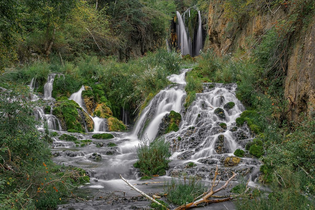
Other waterfalls in Spearfish Canyon, such as Roughlock Falls and Spearfish Falls. The Spearfish Canyon Scenic Byway offers stunning views and hiking opportunities.
Wildlife
Visitors may spot deer, birds, and other wildlife native to the Black Hills region.
Cities near Bridal Veil Falls
Nearby Waterfalls
Other waterfalls named Bridal Veil Falls
24 other waterfalls share this name across the U.S.
Writing about Bridal Veil Falls? Embed this waterfall on your site for free.