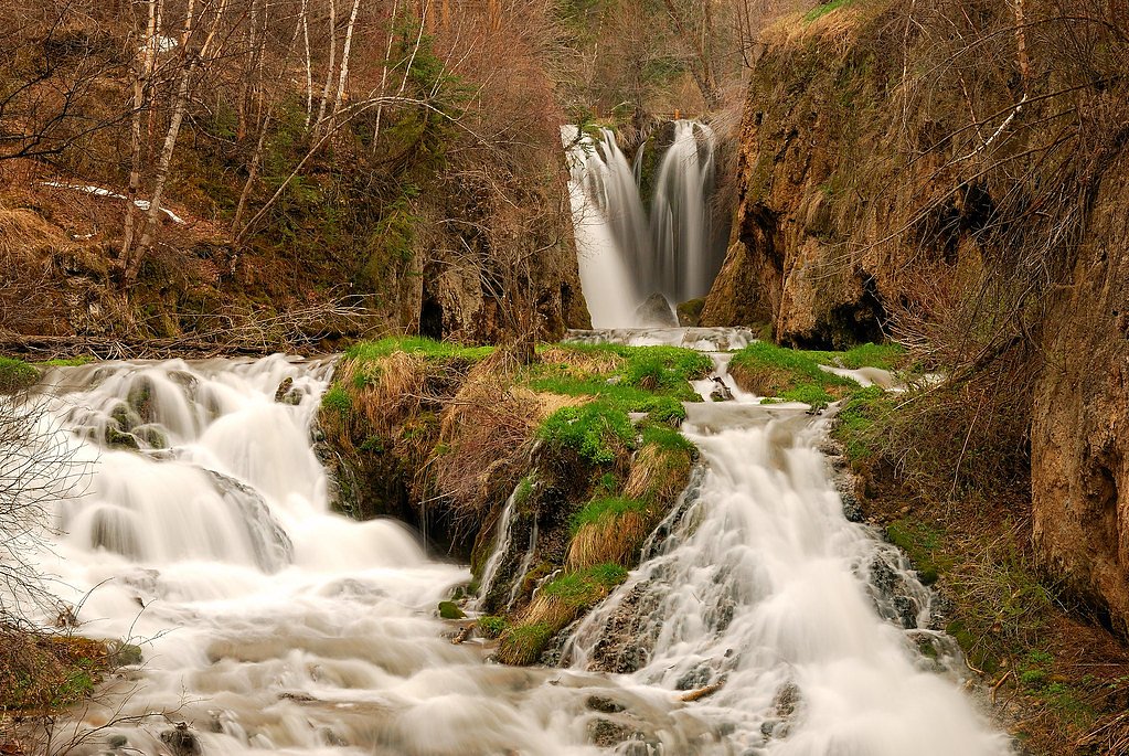
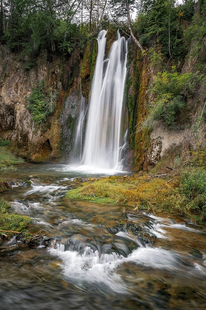
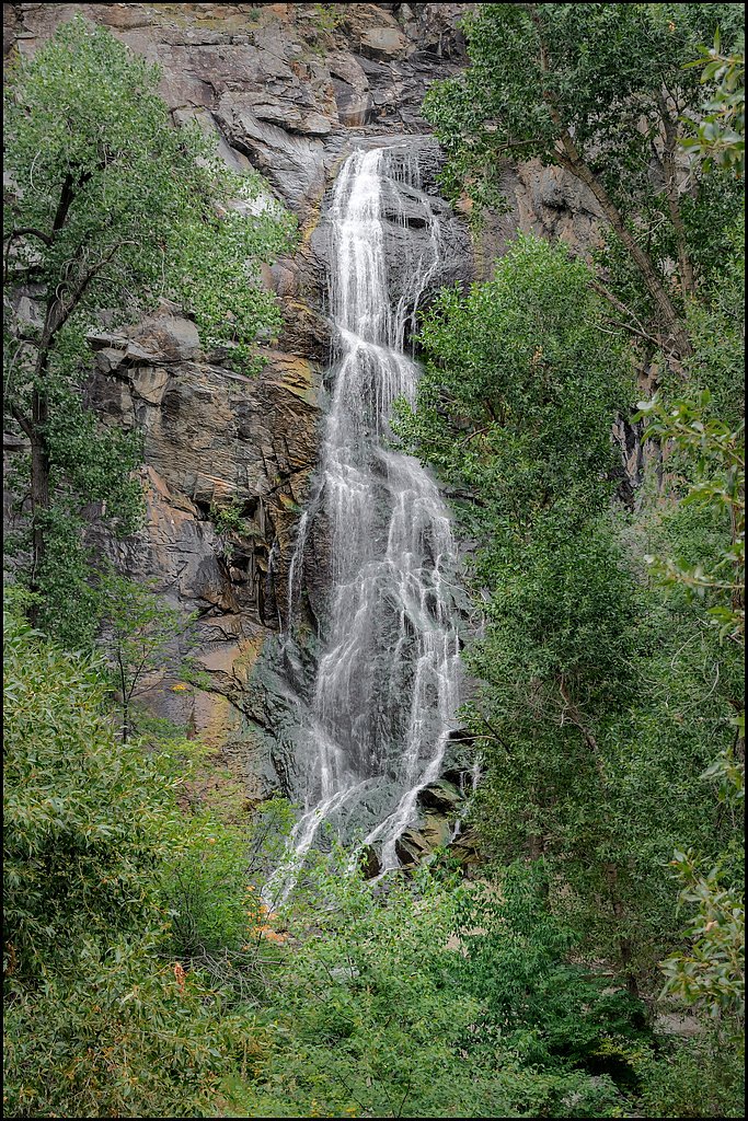
Roughlock Falls
By Armen Suny · Last verified May 2026
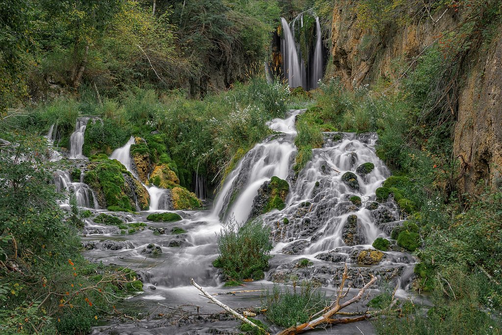
Photo Credits (3)
Difficulty
Moderate
Trail Length
2.4 miles
Trail Type
Out And Back
Elevation Gain
350 ft
About Roughlock Falls
Roughlock Falls is a picturesque cascade tucked into Spearfish Canyon in the northern Black Hills. The waterfall and its immediate surroundings lie within the Black Hills National Forest and are managed by the U.S. Forest Service, making the area a well-loved stop for photographers, day hikers, and anyone wanting a quick dose of canyon scenery. Framed by the steep walls of Spearfish Canyon, the falls offer an inviting blend of rushing water and wooded outlooks that reward a short outing. Getting to the falls involves a moderate out-and-back walk that delivers big scenery in a compact package. The route uses a combination of native-surface tread and a USFS-designated spur—Rimrock Spur B (Trail #79B)—which provides a slightly steeper approach. At about 2.4 miles round-trip with roughly 350 feet of elevation gain, the hike is approachable for most hikers who are comfortable on natural single-track and modest grades.
The Setting
Roughlock Falls sits at 5,131 feet within Black Hills National Forest, fed by the Little Spearfish Creek, in the high mountains of South Dakota.
Nearby Falls Worth Visiting
Spearfish Falls, the tallest waterfall in South Dakota at 47 feet, lies 0.7 miles to the east.
Trail & Hike Details
The Approach
The moderate hike follows Rimrock Spur B (#79B), a 2.4-mile out and back trail over natural surface. Expect 350 feet of elevation gain with grades of 12-20%. The trail is developed (Class 3).
USFS Trail
RIMROCK SPUR B #79B
Trail Class
Developed
Surface
Avg Grade
USFS Segment
0.78 miTrail Description
Out-and-back, 2.4 miles total with approximately 350 feet of elevation gain; rated moderate. The route includes the USFS Rimrock Spur B (Trail #79B), a Class 3 segment with a native-material (NAT) surface and a typical grade of 12–20%. The Rimrock Spur B segment is recorded at about 0.78 GIS miles, and the overall tread is natural/primitive. Expect native soil and rock footing, short steeper stretches on the spur, and trail conditions typical of a forested canyon single-track managed by Black Hills National Forest (U.S. Forest Service).
What to Expect
Dogs are welcome.
Accessibility
The trail is not wheelchair accessible. Uneven terrain and elevation changes require steady footing.
Frequently Asked Questions
🐶 Are Dogs Allowed at Roughlock Falls?
✅ Dogs are allowed
Are There Any Fees or Permits Required?
🆖 No fees required
🏊 Is There Swimming at Roughlock Falls?
❌ Swimming is not allowed
When to Visit
Spring and summer are ideal for lush greenery and flowing water, while fall offers vibrant foliage. Winter provides a unique view of the falls with ice formations.
Seasonal Access
The best time to visit is Spring, Summer, Fall, and Winter. Check with Black Hills National Forest for seasonal road closures.
Safety Information
Stay on designated trails and viewing platforms to avoid slippery rocks and steep drop-offs. Be cautious during winter as icy conditions may make paths hazardous.
Current Water Conditions
14 ft³/s
Current discharge — how much water is flowing
Lower than usual for this time of year
Based on 36 years of record
4.61 ft
Water depth at gauge
7-Day Discharge Trend
What does this mean for your visit?
Flow is lower than usual for this time of year.
About This Gauge
7-Day Flow Outlook
Based on the USGS gauge LITTLE SPEARFISH CREEK NEAR LEAD, SD (1 km away).
Today
Roaring
16 cfs
6/10Tomorrow
Roaring
18 cfs
6/10Sun
Roaring
16 cfs
9/10Mon
Strong
15 cfs
10/10Tue
Strong
14 cfs
10/10Wed
Roaring
16 cfs
6/10Thu
Roaring
18 cfs
6/10Best window: Mon — strong flow, sunny (trip score 10/10).
Best time of year: this gauge typically runs highest from early May to late June, peaking in June.
How we calculate this
This is a transparent outlook, not a precise forecast. We take the waterfall's current flow strength (how it ranks against its historical normal for today, from the nearest USGS stream gauge), carry that ranking forward along the gauge's seasonal curve, and nudge it for forecast rain. Confidence is highest for the next day or two and falls further out. Always check official conditions and your own judgment before visiting — high flows can be dangerous.
Know when to go.
Get a free email alert when waterfalls near Lead hit peak flow. We only send when conditions are worth the trip — no weekly newsletters, no spam.
Weather Forecast
Location & Access
Getting There
Roughlock Falls is located in Spearfish Canyon, accessible via Roughlock Falls Road off US Highway 14A. The road is well-marked and leads directly to the falls.
Get Directions on Google MapsParking
There is a designated parking area near the falls, which is free to use. It is typically spacious but may fill up during peak seasons.
Hours
Elevation
5,131 feet above sea level
Coordinates
44.349893° N, -103.943011° W
Land Management
Managed by USFS
Visitor Tips & Gear
Visit early in the morning or on weekdays to avoid crowds. Wear comfortable walking shoes if hiking, and bring a camera to capture the stunning scenery. Check weather conditions during winter as snow may impact access.
As an Amazon Associate, we earn from qualifying purchases.
With 2.4 miles and 350 ft of elevation gain, sturdy boots and trekking poles will help on this moderate trail. Icy conditions are common in winter — traction cleats are a smart addition.

Columbia Watertight II Rain Jacket
Packs into its own pocket, seam-sealed, and keeps you dry from spray and surprise rain.

Polarized Sunglasses (Knockaround)
Cuts glare off the water so you actually see the falls — and your photos turn out better too.

Earth Pak Waterproof Dry Bag
Keeps your phone and gear dry when waterfall mist soaks everything else.

Waterproof Phone Pouch (AiRunTech)
Cheap insurance — take photos right next to the falls without killing your phone.

Timberland Euro Sprint Mid Waterproof
Trusted waterproof boot with premium leather and grippy rubber sole — reliable on rocky, wet trails.

TrailBuddy Trekking Poles
Lightweight aluminum, cork grips, and flip-locks that actually hold — a best-seller for good reason.
Where to Stay

Iron Wood Lodge

Hampton Inn Lead

The Lodge at Deadwood

Spearfish Canyon Lodge
Browse vacation cabins and private rentals nearby
Unique outdoor stays — tents, yurts, and treehouses
Rent a campervan or RV for your waterfall road trip
Some links are affiliate links. We may earn a commission at no extra cost to you.
Nearby Campground
Northern Hills-Spearfish
11.2 miles away · 0 sites
The Northern Hills Ranger District covers the northern portion of the Black Hills on the South Dakota side. Spearfish has nearby access to over 300 miles of snowmobile trails, groomed and ungroomed cross-country ski trails, a 100 mile long hiking trail (Centennial Trail) and many other trails, a 110 mile long biking, hiking and horseback trail (Mickelson Trail), and 2 downhill ski areas (ski areas are near Deadwood, SD - 15 miles away).
Book on Recreation.govAdditional Information
Nearby Attractions
Spearfish Canyon Scenic Byway, Bridal Veil Falls, Spearfish Falls, and the town of Spearfish.
Wildlife
Visitors may spot deer, birds, and other wildlife common to the Black Hills region.
Cities near Roughlock Falls
Nearby Waterfalls
Writing about Roughlock Falls? Embed this waterfall on your site for free.