Bridal Veil Falls
Ontario • 11 m
By Armen Suny · Last verified Jun 2026
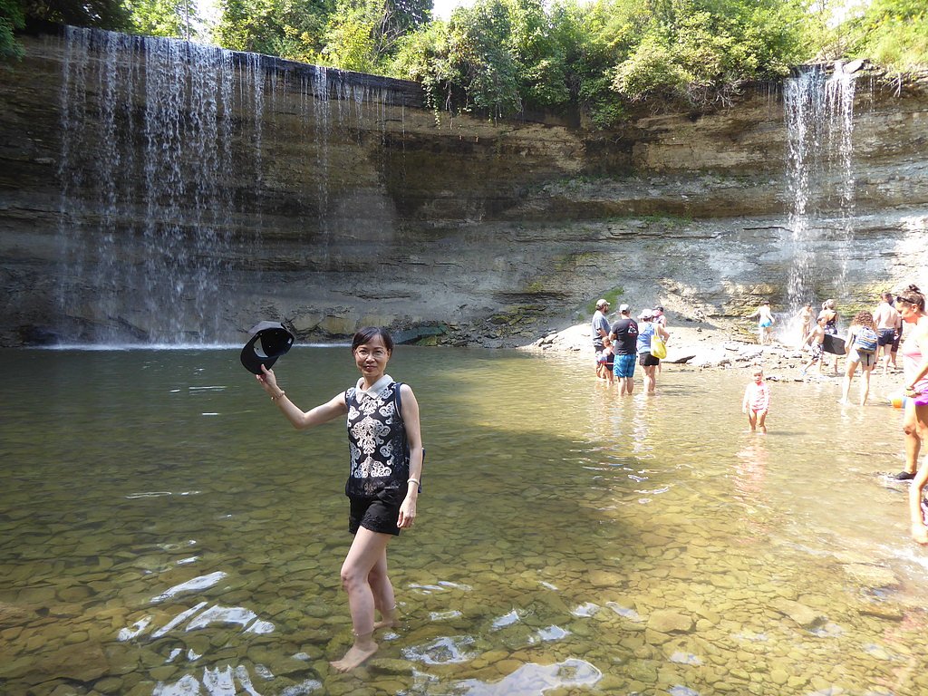
Photo Credits (2)
Difficulty
Easy
Trail Length
1.3 km
Trail Type
Out And Back
Elevation Gain
23 m
About Bridal Veil Falls
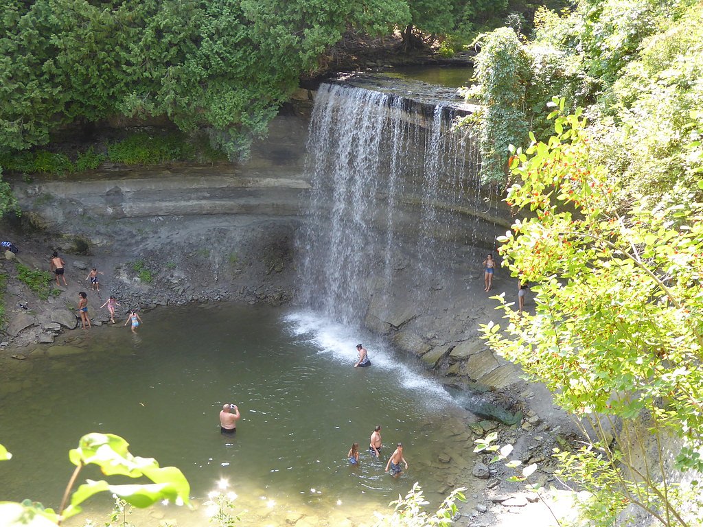
Bridal Veil Falls is a waterfall near the town of Kagawong on Lake Huron's Manitoulin Island, Ontario, Canada. The water source is the Kagawong River, which flows from Lake Kagawong to the North Channel of Lake Huron.
The Setting
Bridal Veil Falls sits at 212 metres in the foothills of Ontario. The falls drop 11 metres.
Why This Waterfall Exists
Bridal Veil Falls flows over layered sedimentary rock laid down about 444-458 million years ago. Over time, the stream has worn through these layers at different rates, creating a 36-foot drop that forms the waterfall.
Trail & Hike Details
The Approach
The easy 1.3-km out-and-back trail gains 23 metres of elevation on the way to the falls.
Trail Description
A short, likely less-than-half-mile round-trip trail from the parking/pull-off leads down to viewpoints of the falls. The path is natural (dirt/rock), may include short stair-like sections or roots, and usually ends at one or more informal viewing areas. There may not be boardwalks, railings, or developed viewing platforms.
What to Expect
The falls drop 11 metres over layered sedimentary rock.
Accessibility
The trail is short and relatively flat, but the surface may be uneven. Contact the managing agency for accessibility details.
Frequently Asked Questions
🐶 Are Dogs Allowed at Bridal Veil Falls?
❌ Dogs are not allowed
Are There Any Fees or Permits Required?
🆖 No fees required
🏊 Is There Swimming at Bridal Veil Falls?
❌ Swimming is not allowed
When to Visit
Spring (late March–May) for peak flow and dramatic water volume; early morning or weekday visits for fewer visitors and better light for photography. Fall can offer good colors and cooler weather. Winter visits may provide frozen cascades but expect icy, hazardous access, only for experienced visitors with proper gear.
Seasonal Access
The best time to visit is Spring, Summer, Fall, and Winter. Check with the managing park or local authority for current conditions.
Safety Information
Hazards include slippery rocks and trails (especially when wet or icy), steep/unstable edges near the falls, strong currents during high flow, limited cell service in some areas, insect bites/ticks, and fall risk on natural surfaces. In winter, ice can make approaches extremely hazardous, use crampons/ice cleats and extreme caution. Always stay on designated paths, avoid climbing on wet rocks near edges, supervise children closely, and check local conditions and weather before visiting.
Current Water Conditions
Based on a Water Survey of Canada gauge 34.7 km away
0.5 m³/s
Current discharge — how much water is flowing
Much higher than usual for this time of year
Based on 32 years of record
7.95 m
Water depth at gauge
7-Day Discharge Trend
What does this mean for your visit?
The water is flowing much higher than usual, expect an impressive display.
About This Gauge
This gauge is on a regional waterway. Conditions at the falls may differ, especially after local rain.
7-Day Flow Outlook
Based on the WSC gauge BLUE JAY CREEK NEAR TEHKUMMAH (35 km away).
Today
Roaring
0.5 m³/s
8/10Tomorrow
Roaring
0.6 m³/s
6/10Tue
Roaring
0.6 m³/s
6/10Wed
Roaring
0.6 m³/s
6/10Thu
Roaring
0.5 m³/s
8/10Fri
Roaring
0.6 m³/s
6/10Sat
Roaring
0.5 m³/s
8/10Best window: Today — roaring flow, cloudy (trip score 8/10).
Best time of year: this gauge typically runs highest from mid March to early May, peaking in April.
How we calculate this
This is a transparent outlook, not a precise forecast. We take the waterfall's current flow strength (how it ranks against its historical normal for today, from the nearest WSC stream gauge), carry that ranking forward along the gauge's seasonal curve, and nudge it for forecast rain. Confidence is highest for the next day or two and falls further out. Always check official conditions and your own judgment before visiting — high flows can be dangerous.
Know when to go.
Get a free email alert when waterfalls near Little Current hit peak flow. We only send when conditions are worth the trip — no weekly newsletters, no spam.
Weather Forecast
Location & Access
Getting There
The waterfall is located on Manitoulin Island, approximately 16.8 miles (as reported) from Little Current. Expect rural island roads; use local maps or GPS coordinates (45.9008, -82.2553) to navigate. Driving is on two-lane paved and secondary roads for parts of the route.
Get Directions on Google MapsParking
There is typically a small roadside pull-off or informal parking area near the trailhead. Parking may be limited and there are likely no formal facilities or services; park responsibly without blocking the road.
Elevation
212 metres above sea level
Coordinates
45.900829° N, -82.255313° W
Visitor Tips & Gear
Wear sturdy, closed-toe footwear with good traction. Bring insect repellent in spring/early summer (black flies and mosquitoes can be prevalent) and tick awareness gear. Respect private property, access may be across or adjacent to private land, so stay on designated trail/access points. Pack out what you pack in. Check local resources for up-to-date access info before visiting.
As an Amazon Associate, we earn from qualifying purchases.
For this easy 1.3 km trail, lightweight trail shoes and a water bottle are usually sufficient. Icy conditions are common in winter — traction cleats are a smart addition.

Columbia Watertight II Rain Jacket
Packs into its own pocket, seam-sealed, and keeps you dry from spray and surprise rain.

Polarized Sunglasses (Knockaround)
Cuts glare off the water so you actually see the falls — and your photos turn out better too.

Earth Pak Waterproof Dry Bag
Keeps your phone and gear dry when waterfall mist soaks everything else.

Waterproof Phone Pouch (AiRunTech)
Cheap insurance — take photos right next to the falls without killing your phone.

Kahtoola MICROspikes
Cult-favorite traction cleats that grip ice and wet rock — essential for winter waterfall hikes.

JOBY GorillaPod Starter Kit
Wraps around railings and rocks for long-exposure waterfall shots — no flat surface needed.
Where to Stay
Browse vacation cabins and private rentals nearby
Unique outdoor stays — tents, yurts, and treehouses
Rent a campervan or RV for your waterfall road trip
Some links are affiliate links. We may earn a commission at no extra cost to you.
Nearby Campground
Norm's Tent and Trailer Park
1.8 km away
Additional Information
Nearby Attractions
Manitoulin Island attractions (towns, scenic drives, other waterfalls and hikes). Little Current is the nearest larger community (approximately 16.8 miles as reported). Check local visitor information for additional nearby trails and parks.
Wildlife
Typical island and Ontario woodland wildlife: songbirds, waterfowl, white-tailed deer, small mammals. Insect activity (black flies, mosquitoes) in spring and early summer; ticks may be present, take precautions.
Cities near Bridal Veil Falls
Other waterfalls named Bridal Veil Falls
24 other waterfalls share this name across Canada.
Writing about Bridal Veil Falls? Embed this waterfall on your site for free.