Photo Credits (5)
Difficulty
Moderate
Trail Length
2.6 miles
Trail Type
Out And Back
Elevation Gain
500 ft
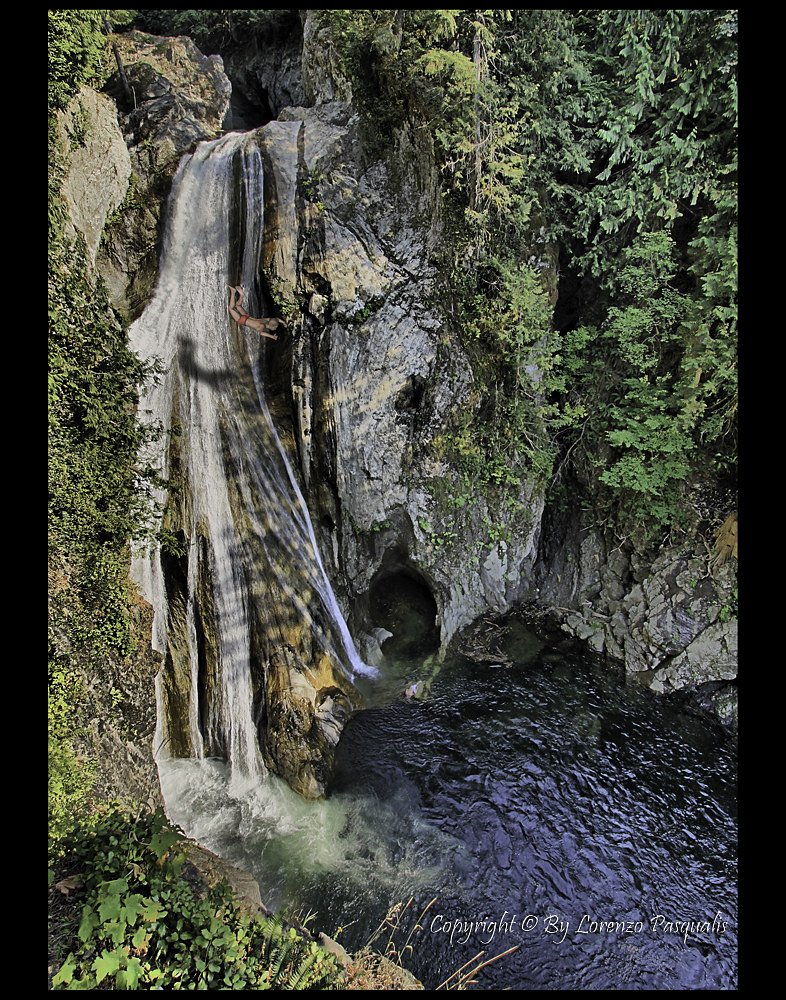
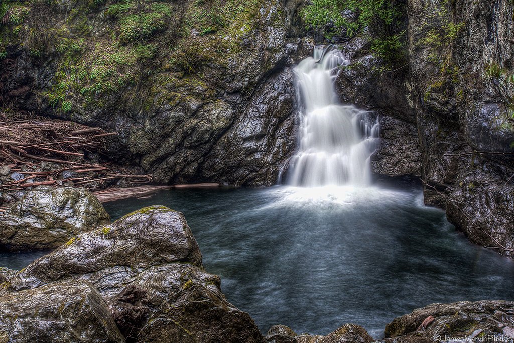
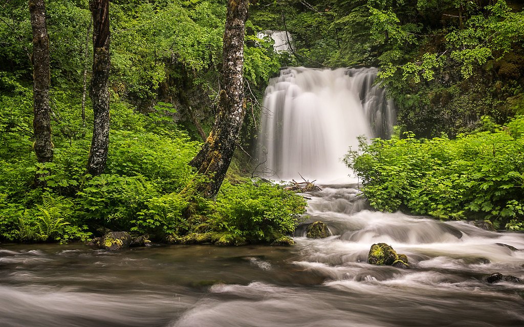
About Twin Falls
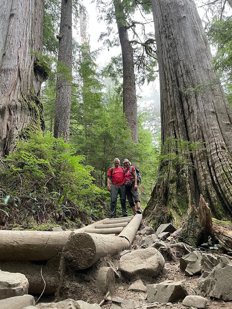
Twin Falls sits just outside Verlot, Washington, where two distinct cascades drop through a verdant forest corridor inside the Morning Star Natural Resources Conservation Area. This State Conservation Area (SCA) is managed by SDNR, and the falls reward a short hike with classic Pacific Northwest scenery—towering evergreens, moss-draped trunks, and the twin plunges that make for lovely photos and a peaceful stop on a day outing. The route to the viewpoints is a moderately paced out-and-back that gains about 500 feet over roughly 2.6 miles, so it’s popular with hikers looking for a satisfying but not overly long trek. If you’re planning to camp nearby, Gold Basin Campground is about 5.34 km from the trailhead, making an overnight stay convenient for those who want more time to explore the area or catch quieter light at dawn and dusk.
The Setting
Twin Falls sits at 2,375 feet within Morning Star Natural Resources Conservation Area, fed by the Sultan River, in the hills of Washington.
Trail & Hike Details
The Approach
The moderate 2.6-mile out-and-back trail gains 500 feet of elevation on the way to the falls.
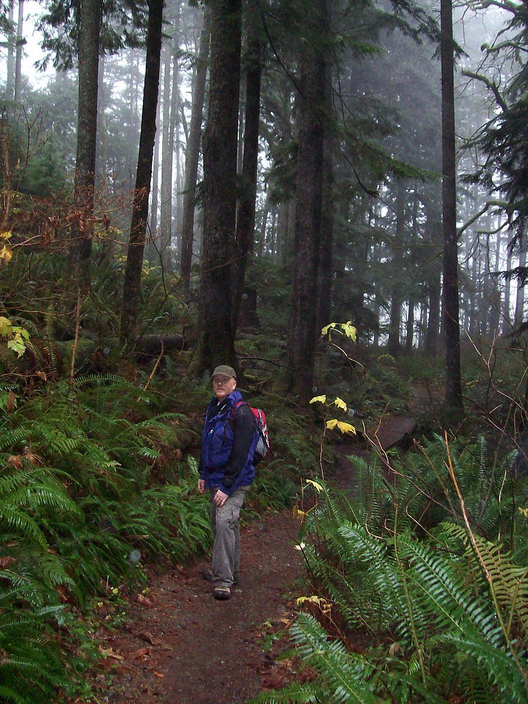
Trail Description
Trail type: out-and-back. Distance: 2.6 miles (total). Elevation gain: approximately 500 feet. Difficulty: moderate. The path winds through dense forest and includes some steady uphill sections—expect a moderate grade rather than steep technical climbs. After rain the trail can have muddy or slippery stretches, so good footwear is recommended. This route is managed as part of the Morning Star Natural Resources Conservation Area by SDNR; there is no USFS trail number or USFS surface/grade/class data associated with this SDNR-managed trail.
What to Expect
Dogs are welcome.
Accessibility
The trail is not wheelchair accessible. Uneven terrain and elevation changes require steady footing.
Frequently Asked Questions
🐶 Are Dogs Allowed at Twin Falls?
✅ Dogs are allowed
Are There Any Fees or Permits Required?
🤑 Fee: $5.00
Permit required
A Northwest Forest Pass or equivalent is required for parking at the trailhead.
🏊 Is There Swimming at Twin Falls?
❌ Swimming is not allowed
When to Visit
Spring and early summer are ideal for visiting Twin Falls, as the water flow is typically at its peak due to snowmelt. Fall offers beautiful foliage, while winter may provide a quieter experience, though trail conditions could be icy.
Seasonal Access
The best time to visit is Spring, Summer, Fall, and Winter.
Safety Information
Exercise caution near the falls, as rocks can be slippery and the water currents strong. Check weather conditions before visiting, as heavy rain can make the trail hazardous.
Current Water Conditions
109 ft³/s
Current discharge — how much water is flowing
About average for this time of year
Based on 38 years of record
25.74 ft
Water depth at gauge
53°F
ColdBracing — limit time in water
7-Day Discharge Trend
What does this mean for your visit?
Flow is about average for this time of year. Water temperature is a bracing 53 degrees F, limit your time in the water.
About This Gauge
This gauge is on a nearby waterway and may not reflect exact conditions at the falls.
7-Day Flow Outlook
Based on the USGS gauge SULTAN RIVER BELOW DIVERSION DAM NEAR SULTAN, WA (9 km away).
Today
Roaring
127 cfs
6/10Tomorrow
Roaring
128 cfs
6/10Sun
Roaring
123 cfs
6/10Mon
Roaring
127 cfs
6/10Tue
Roaring
123 cfs
6/10Wed
Roaring
124 cfs
6/10Thu
Roaring
126 cfs
6/10Best window: Today — roaring flow, showers and thunderstorms likely (trip score 6/10).
Best time of year: this gauge typically runs highest from early March to late April, peaking in October.
How we calculate this
This is a transparent outlook, not a precise forecast. We take the waterfall's current flow strength (how it ranks against its historical normal for today, from the nearest USGS stream gauge), carry that ranking forward along the gauge's seasonal curve, and nudge it for forecast rain. Confidence is highest for the next day or two and falls further out. Always check official conditions and your own judgment before visiting — high flows can be dangerous.
Know when to go.
Get a free email alert when waterfalls near Verlot hit peak flow. We only send when conditions are worth the trip — no weekly newsletters, no spam.
Weather Forecast
Location & Access
Getting There
Twin Falls is located approximately 4.6 miles from Verlot, 8.3 miles from Startup, and 9.5 miles from Lake Roesiger. The coordinates for the falls are 48.0295, -121.7407. Access is typically via Mountain Loop Highway, with signage leading to nearby trailheads.
Get Directions on Google MapsParking
Parking is available at designated trailheads along Mountain Loop Highway. Availability may vary depending on the season and time of day.
Elevation
2,375 feet above sea level
Coordinates
48.029548° N, -121.740679° W
Land Management
Managed by SDNR
Visitor Tips & Gear
Arrive early to secure parking, especially on weekends. Wear sturdy hiking shoes, as the trail can be uneven or slippery. Bring water and snacks, and be prepared for changing weather conditions.
As an Amazon Associate, we earn from qualifying purchases.
With 2.6 miles and 500 ft of elevation gain, sturdy boots and trekking poles will help on this moderate trail. Icy conditions are common in winter — traction cleats are a smart addition.

Columbia Watertight II Rain Jacket
Packs into its own pocket, seam-sealed, and keeps you dry from spray and surprise rain.

Polarized Sunglasses (Knockaround)
Cuts glare off the water so you actually see the falls — and your photos turn out better too.

Earth Pak Waterproof Dry Bag
Keeps your phone and gear dry when waterfall mist soaks everything else.

Waterproof Phone Pouch (AiRunTech)
Cheap insurance — take photos right next to the falls without killing your phone.

Timberland Euro Sprint Mid Waterproof
Trusted waterproof boot with premium leather and grippy rubber sole — reliable on rocky, wet trails.

TrailBuddy Trekking Poles
Lightweight aluminum, cork grips, and flip-locks that actually hold — a best-seller for good reason.
Where to Stay

Dutch Cup Motel

Executive Residency by Best Western Navigator Inn & Suites

Inn at Port Gardner-Everett Waterfront, Ascend Hotel Collection

La Quinta Inn by Wyndham Lynnwood
Browse vacation cabins and private rentals nearby
Unique outdoor stays — tents, yurts, and treehouses
Rent a campervan or RV for your waterfall road trip
Some links are affiliate links. We may earn a commission at no extra cost to you.
Nearby Campground
Gold Basin Campground
3.3 miles away · 41 sites
Overview Gold Basin Campground sits near the banks of the tranquil South Fork of the Stillaguamish River, close to several wilderness areas and hiking trails, offering visitors opportunities to experience both the serene and wild aspects of the Cascade region. Gold Basin features 39 primitive campsites and vault toilets. Recreation In addition to being a prime location for hiking, biking, fishing, picnicking and horseback riding in summer and early fall, Gold Basin offers excellent skiing and sno
Book on Recreation.govNearby Hot Springs
Hot springs near Verlot, Washington
Garland Mineral Springs
Garland Mineral Springs flows at 84 degrees in the Snoqualmie National Forest, producing water 39.6 degrees above ambient tempe...
Kennedy Hot Spring
Kennedy Hot Spring flows at 100 degrees at 3,520 feet elevation in the Mt. Baker National Forest, emerging 58.7 degrees above a...
Gamma Hot Springs
Gamma Hot Springs produces 140-degree water at 5,397 feet elevation in the Mt. Baker National Forest, emerging 104.6 degrees ab...
Sulphur Creek Hot Springs
Sulphur Creek Hot Springs flows at 99 degrees Fahrenheit at 2,973 feet elevation in Mount Baker National Forest's remote backco...
Scenic Hot Springs
Scenic Hot Springs delivers genuinely hot water at 122 degrees Fahrenheit at 2,246 feet elevation in the Cascade Mountains near...
Goldmeyer Hot Springs
Goldmeyer Hot Springs emerges at 127 degrees in the central Cascades, producing water 78.9 degrees above ambient temperature at...
Looking for a soak after your hike? Explore more hot springs near Verlot, Washington on SoakingSprings.
Explore Washington springsAdditional Information
Nearby Attractions
Nearby attractions include the Mountain Loop Highway, Lake Roesiger, and other hiking trails in the Verlot area.
Wildlife
The area is home to various wildlife, including birds, deer, and small mammals. Be cautious of bears and other larger animals, especially during dawn and dusk.
Cities near Twin Falls
Nearby Waterfalls

Other waterfalls named Twin Falls
21 other waterfalls share this name across the U.S.
Writing about Twin Falls? Embed this waterfall on your site for free.