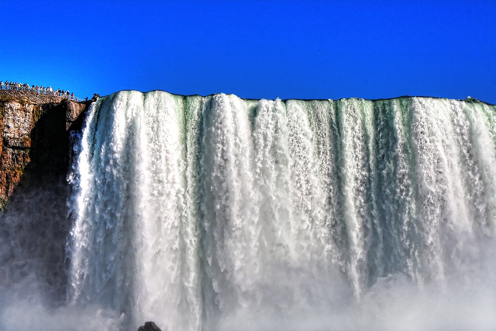
Twin Falls
Ontario • Sturgeon River Provincial Park
By Armen Suny · Last verified Jun 2026
Photo Credits (1)
About Twin Falls
Twin Falls (near coordinates 47.173, -80.7847) is a pair of cascades in the boreal forest north of Greater Sudbury, Ontario (approximately 40–41 miles by road). Visitor reports indicate a relatively natural, undeveloped setting with viewpoints reached by a short forest trail or roadside access in some seasons. Flow is typically highest in spring and after heavy rain; in winter the falls may be partially or fully frozen and icy.
The Setting
Twin Falls sits at 350 metres within Sturgeon River Provincial Park, in the foothills of Ontario.
Why This Waterfall Exists
Twin Falls flows over hard intrusive rock, primarily granodiorite and granite, laid down over 2.5-3.2 billion years ago. These resistant rocks form a durable ledge that water cannot easily wear away, creating the falls where softer material downstream has already eroded.
Trail & Hike Details
Trail Description
Trail approaches reported for this Twin Falls are generally short but may be unmaintained single-track through mixed conifer and deciduous forest with roots and rocks. In some conditions the falls can be seen from a roadside viewpoint or reached via a brief walk; other reports describe a short descent to a natural viewpoint near the water. Trails may be muddy, uneven, and have sections with exposed rock, use caution on wet surfaces.
What to Expect
Expect a remote, natural waterfall setting rather than a developed park site. There may be limited or no facilities (no restrooms, no formal viewing platforms). Seasonal flow varies: highest in spring runoff, lower in late summer/fall unless recent rain. In winter, portions may be frozen and surrounding terrain icy. Wildlife typical of northern Ontario (moose, deer, black bear, beaver) and bugs (black flies, mosquitoes) are common in appropriate seasons.
Accessibility
Access is likely not wheelchair accessible. Trails and viewpoints are probably natural, uneven, and may include roots, rocks, and steps. Expect limited to no formal accessibility infrastructure.
Frequently Asked Questions
🐶 Are Dogs Allowed at Twin Falls?
❌ Dogs are not allowed
Are There Any Fees or Permits Required?
🆖 No fees required
🏊 Is There Swimming at Twin Falls?
❌ Swimming is not allowed
When to Visit
Spring (high water for best views) and fall (autumn colours) are often the most rewarding. Summer offers easier access but may have lower flow; winter provides scenic ice formations but requires winter travel experience and caution for icy conditions.
Seasonal Access
The best time to visit is Spring, Summer, Fall, and Winter. Check with Sturgeon River Provincial Park for current conditions.
Safety Information
Hazards include slippery wet rocks, steep or unstable banks near the water, strong currents near the falls, cold water temperatures, variable trail conditions, limited cell service, and biting insects in warmer months. In winter expect icy conditions and potential for deep snow; use appropriate winter gear. Always let someone know your plans and estimated return time.
Current Water Conditions
Based on a Water Survey of Canada gauge 33.4 km away
5.8 m³/s
Current discharge — how much water is flowing
About average for this time of year
Based on 39 years of record
4.57 m
Water depth at gauge
7-Day Discharge Trend
What does this mean for your visit?
Flow is about average for this time of year.
About This Gauge
This gauge is on a regional waterway. Conditions at the falls may differ, especially after local rain.
7-Day Flow Outlook
Based on the WSC gauge STURGEON RIVER AT UPPER GOOSE FALLS (33 km away).
Today
Moderate
5.7 m³/s
6/10Tomorrow
Moderate
6.0 m³/s
5/10Tue
Moderate
6.2 m³/s
5/10Wed
Moderate
5.5 m³/s
6/10Thu
Moderate
5.5 m³/s
5/10Fri
Moderate
5.0 m³/s
6/10Sat
Moderate
4.9 m³/s
6/10Best window: Today — moderate flow, fog (trip score 6/10).
Best time of year: this gauge typically runs highest from early April to mid June, peaking in May.
How we calculate this
This is a transparent outlook, not a precise forecast. We take the waterfall's current flow strength (how it ranks against its historical normal for today, from the nearest WSC stream gauge), carry that ranking forward along the gauge's seasonal curve, and nudge it for forecast rain. Confidence is highest for the next day or two and falls further out. Always check official conditions and your own judgment before visiting — high flows can be dangerous.
Know when to go.
Get a free email alert when waterfalls near Sudbury hit peak flow. We only send when conditions are worth the trip — no weekly newsletters, no spam.
Weather Forecast
Location & Access
Getting There
The falls are accessed from secondary roads north of Sudbury. Expect narrow forest roads and at least some unpaved sections; GPS coordinates (47.173, -80.7847) can be used to navigate. Recent visitor reports suggest a small parking/pullout near the trailhead or roadside; roads may be rough and seasonal. Cell service may be limited, download maps or carry a GPS device.
Get Directions on Google MapsParking
There is likely a small unpaved parking or roadside pullout near the trailhead. Parking may be limited and not signed; park well off the road and avoid blocking access.
Elevation
350 metres above sea level
Coordinates
47.173006° N, -80.784684° W
Land Management
Managed by Ontario Parks
Visitor Tips & Gear
1) Wear sturdy, grippy footwear for uneven, wet, and possibly icy surfaces. 2) Bring insect repellent during spring/summer. 3) Carry a map or offline GPS; cell coverage can be spotty. 4) Park fully off the road to avoid blocking traffic. 5) Stay back from cliff edges and wet rocks; there may be no barriers. 6) Check local road and weather conditions before traveling, secondary roads may be rough or seasonally closed.
Where to Stay
Browse vacation cabins and private rentals nearby
Unique outdoor stays — tents, yurts, and treehouses
Rent a campervan or RV for your waterfall road trip
Some links are affiliate links. We may earn a commission at no extra cost to you.
Additional Information
Nearby Attractions
Other northern Ontario outdoor opportunities (trails, lakes, provincial parks) exist in the wider region; specific nearby attractions and services (fuel, food) may be some distance away, plan accordingly.
Wildlife
Possible sightings include moose, white-tailed deer, black bear, beaver, and a variety of bird species. Insects such as mosquitoes and black flies are common in spring and summer.
Cities near Twin Falls
Nearby Waterfalls
Other waterfalls named Twin Falls
21 other waterfalls share this name across Canada.
Writing about Twin Falls? Embed this waterfall on your site for free.