Twin Falls
By Armen Suny · Last verified Mar 2026
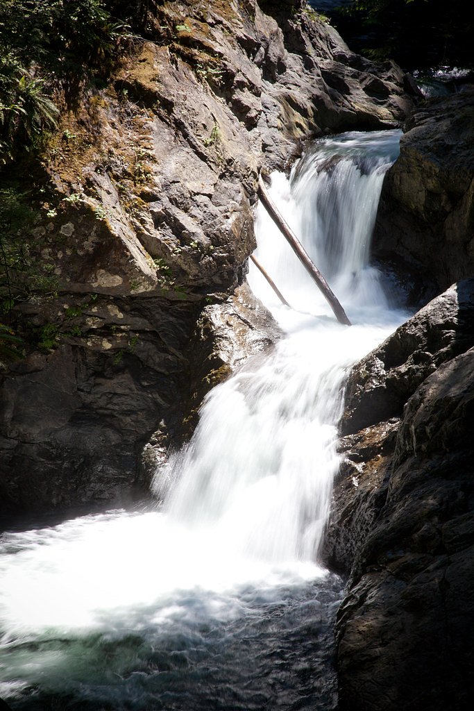
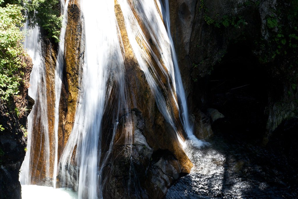
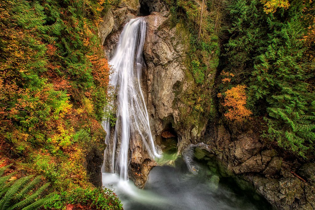
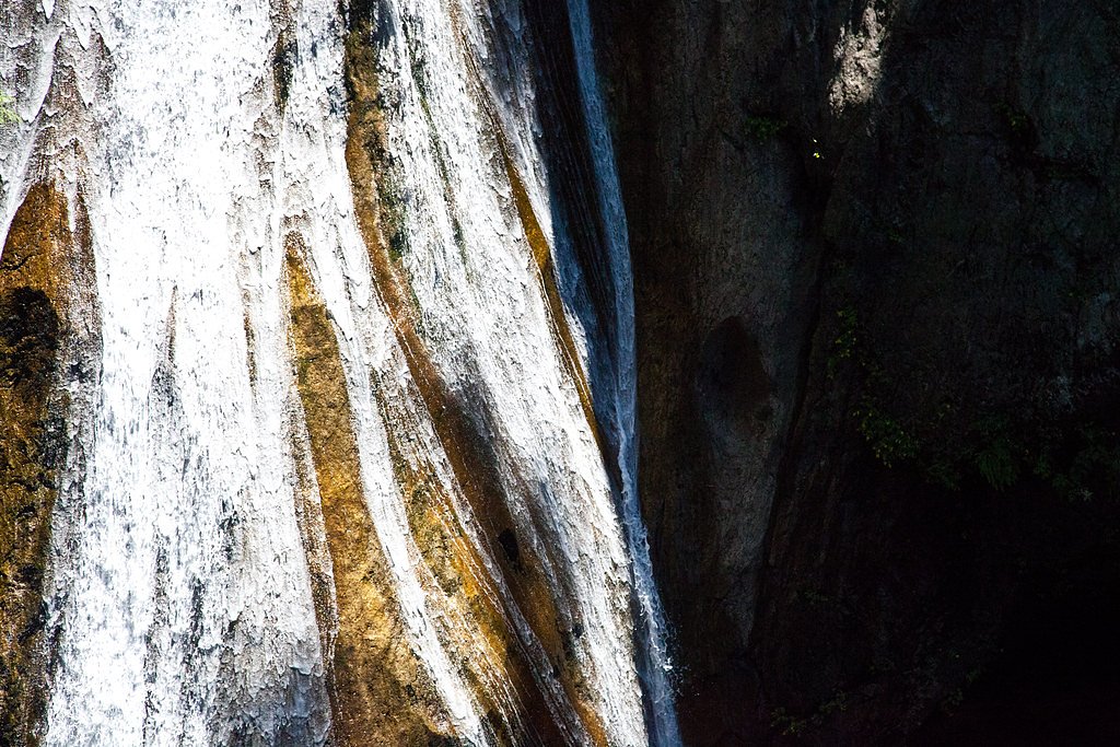

Photo Credits (5)
Difficulty
Moderate
Trail Length
3.6 miles
Trail Type
Out And Back
Elevation Gain
500 ft
About Twin Falls
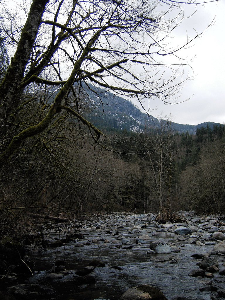
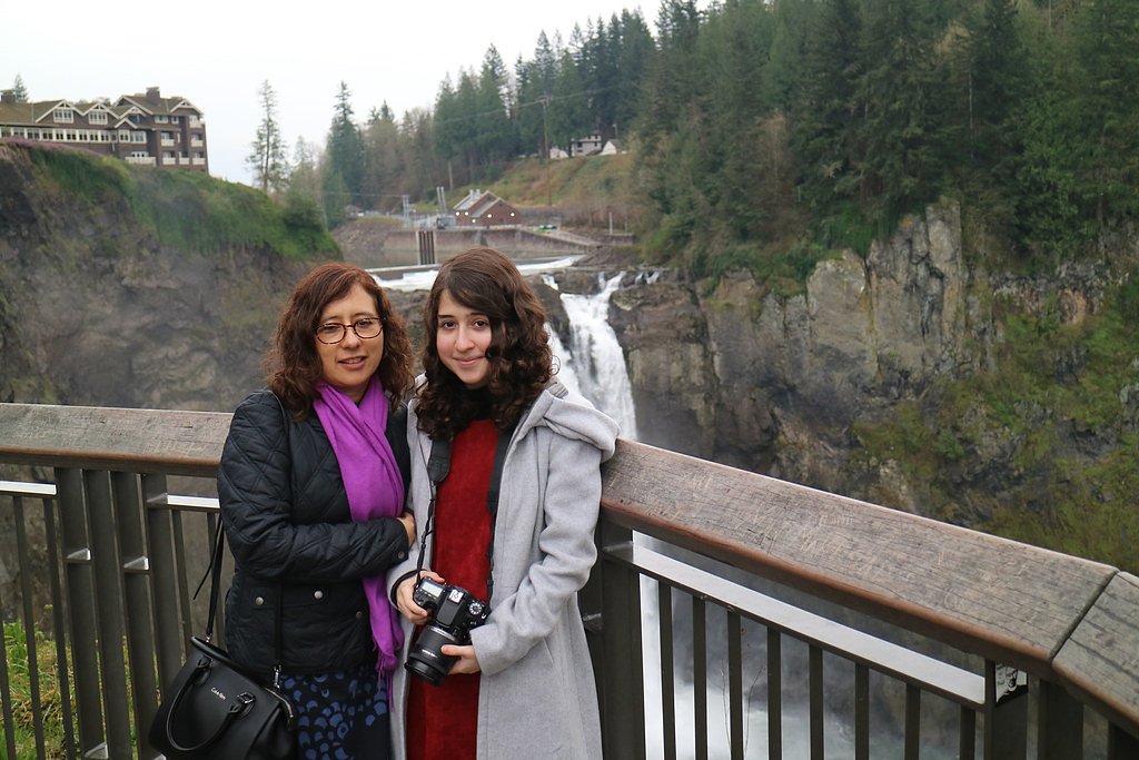
Twin Falls is a stunning waterfall located in Olallie State Park, Washington. It features a series of cascades along the South Fork Snoqualmie River, with the main falls being a popular destination for hikers. The lush forest surroundings and well-maintained trail make it a favorite spot for nature enthusiasts.
The Setting
Twin Falls sits at 866 feet within Olallie, fed by the Sf Snoqualmie River, in the foothills of Washington.
Nearby Falls Worth Visiting
Snoqualmie Falls (268 ft) lies 9.4 miles to the northwest.
Trail & Hike Details
The Approach
The moderate 3.6-mile out-and-back trail gains 500 feet of elevation on the way to the falls.
Trail Description
The trail to Twin Falls is well-maintained and winds through a lush forest of moss-covered trees and ferns. It follows the South Fork Snoqualmie River, offering scenic views and several smaller cascades along the way. The trail includes some moderate elevation gain and a few steep sections, but it is manageable for most hikers. A wooden viewing platform provides an excellent vantage point for the main falls.
What to Expect
Dogs are welcome.
Accessibility
The trail is not wheelchair accessible. Uneven terrain and elevation changes require steady footing.
Frequently Asked Questions
🐶 Are Dogs Allowed at Twin Falls?
✅ Dogs are allowed
Are There Any Fees or Permits Required?
🤑 Fee: $10.00
Permit required
A Discover Pass is required for parking at the trailhead. Passes can be purchased online or at nearby vendors.
🏊 Is There Swimming at Twin Falls?
❌ Swimming is not allowed
When to Visit
Spring and early summer are ideal times to visit, as the waterfall flow is typically strongest due to snowmelt. Fall offers beautiful foliage, while winter provides a quieter experience, though the trail may be icy or muddy.
Seasonal Access
The best time to visit is Spring, Summer, Fall, and Winter.
Safety Information
Exercise caution near the falls and river, as rocks can be slippery. Stay on designated trails to avoid erosion and potential hazards.
Current Water Conditions
127 ft³/s
Current discharge — how much water is flowing
Much lower than usual for this time of year
Based on 45 years of record
6.35 ft
Water depth at gauge
7-Day Discharge Trend
What does this mean for your visit?
Flow is well below normal for this time of year, so the waterfall may be a trickle.
About This Gauge
7-Day Flow Outlook
Based on the USGS gauge SF SNOQUALMIE RIVER AT EDGEWICK, WA (2 km away).
Today
Roaring
137 cfs
6/10Tomorrow
Roaring
129 cfs
6/10Mon
Roaring
123 cfs
6/10Tue
Roaring
120 cfs
6/10Wed
Roaring
113 cfs
6/10Thu
Roaring
115 cfs
6/10Fri
Roaring
110 cfs
6/10Best window: Today — roaring flow, rain showers likely (trip score 6/10).
Best time of year: this gauge typically runs highest from early April to mid June, peaking in May.
How we calculate this
This is a transparent outlook, not a precise forecast. We take the waterfall's current flow strength (how it ranks against its historical normal for today, from the nearest USGS stream gauge), carry that ranking forward along the gauge's seasonal curve, and nudge it for forecast rain. Confidence is highest for the next day or two and falls further out. Always check official conditions and your own judgment before visiting — high flows can be dangerous.
Know when to go.
Get a free email alert when waterfalls near Riverpoint hit peak flow. We only send when conditions are worth the trip — no weekly newsletters, no spam.
Weather Forecast
Location & Access
Getting There
Twin Falls is located off Interstate 90, near North Bend, Washington. Take Exit 34 and follow 468th Avenue SE to the Twin Falls Trailhead parking area.
Get Directions on Google MapsParking
There is a designated parking lot at the Twin Falls Trailhead. A Discover Pass is required for parking.
Elevation
866 feet above sea level
Coordinates
47.444827° N, -121.696772° W
Land Management
Managed by SPR
Visitor Tips & Gear
Arrive early to secure parking, especially on weekends. Wear sturdy hiking shoes as the trail can be muddy in places, particularly after rain. Bring water and snacks, and consider a rain jacket if visiting during wetter months.
As an Amazon Associate, we earn from qualifying purchases.
With 3.6 miles and 500 ft of elevation gain, sturdy boots and trekking poles will help on this moderate trail. Icy conditions are common in winter — traction cleats are a smart addition.

Columbia Watertight II Rain Jacket
Packs into its own pocket, seam-sealed, and keeps you dry from spray and surprise rain.

Polarized Sunglasses (Knockaround)
Cuts glare off the water so you actually see the falls — and your photos turn out better too.

Earth Pak Waterproof Dry Bag
Keeps your phone and gear dry when waterfall mist soaks everything else.

Waterproof Phone Pouch (AiRunTech)
Cheap insurance — take photos right next to the falls without killing your phone.

Timberland Euro Sprint Mid Waterproof
Trusted waterproof boot with premium leather and grippy rubber sole — reliable on rocky, wet trails.

TrailBuddy Trekking Poles
Lightweight aluminum, cork grips, and flip-locks that actually hold — a best-seller for good reason.
Where to Stay

Snoqualmie Inn by Hotel America

Moon River Suites #5

Moon River Suites #4

Moon River Suites #3
Browse vacation cabins and private rentals nearby
Unique outdoor stays — tents, yurts, and treehouses
Rent a campervan or RV for your waterfall road trip
Some links are affiliate links. We may earn a commission at no extra cost to you.
Nearby Campground
Interstate 90 Mountains to Sound Greenway
4.5 miles away · 0 sites
Travel east on Interstate 90 to Snoqualmie Pass, where a multitude of recreational possibilities await you. Don't miss downhill skiing at Snoqualmie Pass. Hike for endless miles in the awe-inspiring Alpine Lakes Wilderness.Mountains to Sound GreenwayDrive Interstate 90 east from Seattle to Snoqualmie Pass, stopping along the way to fish for trout in the Snoqualmie River, or meander along the Asahel Curtis Nature Trail, a one-mile walk through stately old-growth fir and cedar. Leave the freeway at
Book on Recreation.govNearby Hot Springs
Hot springs near Riverpoint, Washington
Goldmeyer Hot Springs
Goldmeyer Hot Springs emerges at 127 degrees in the central Cascades, producing water 78.9 degrees above ambient temperature at...
Lester Hot Springs
This 120-degree spring sits within the City of Tacoma Watershed at 1,582 feet elevation, emerging 72.3 degrees above ambient in...

Mt Rainier Fumaroles
Mount Rainier fumaroles reach 162 degrees at 14,217 feet elevation, emerging 154.8 degrees above ambient at Washington's highes...
Scenic Hot Springs
Scenic Hot Springs delivers genuinely hot water at 122 degrees Fahrenheit at 2,246 feet elevation in the Cascade Mountains near...
Garland Mineral Springs
Garland Mineral Springs flows at 84 degrees in the Snoqualmie National Forest, producing water 39.6 degrees above ambient tempe...

Longmire Mineral Springs
Longmire Mineral Springs flows at 77 degrees within Mount Rainier National Park at 2,758 feet elevation, emerging 31.9 degrees ...
Looking for a soak after your hike? Explore more hot springs near Riverpoint, Washington on SoakingSprings.
Explore Washington springsAdditional Information
Nearby Attractions
Nearby attractions include Snoqualmie Falls, Rattlesnake Ledge, and Mount Si trails.
Wildlife
The area is home to various wildlife, including birds, deer, and small mammals. Keep an eye out for salmon in the river during spawning season.
Cities near Twin Falls
Nearby Waterfalls
Other waterfalls named Twin Falls
21 other waterfalls share this name across the U.S.
Writing about Twin Falls? Embed this waterfall on your site for free.