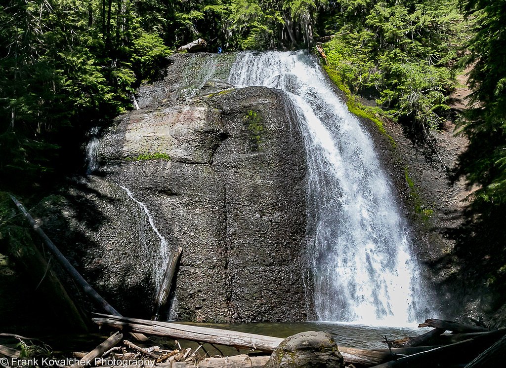
Twin Falls
By Armen Suny · Last verified Mar 2026
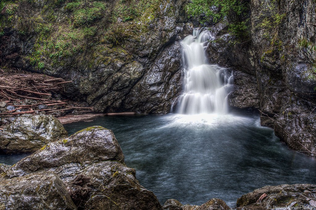
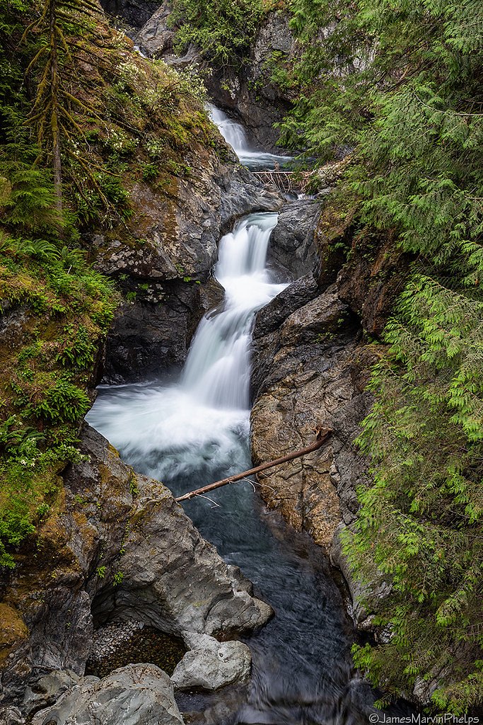
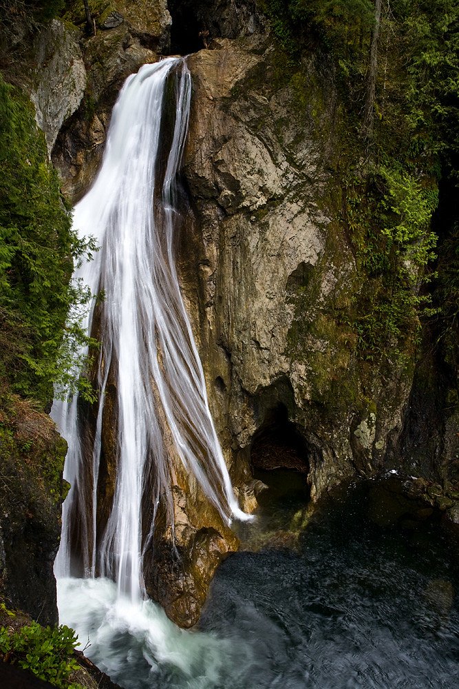
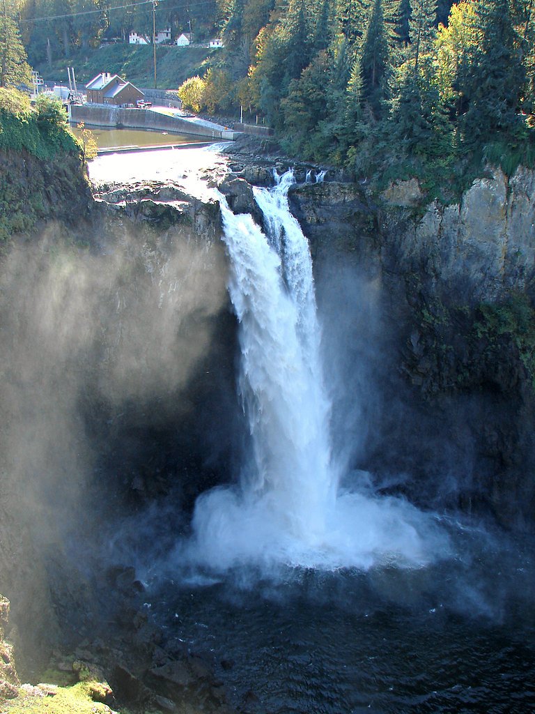
Photo Credits (5)
Difficulty
Moderate
Trail Length
3.6 miles
Trail Type
Out And Back
Elevation Gain
500 ft
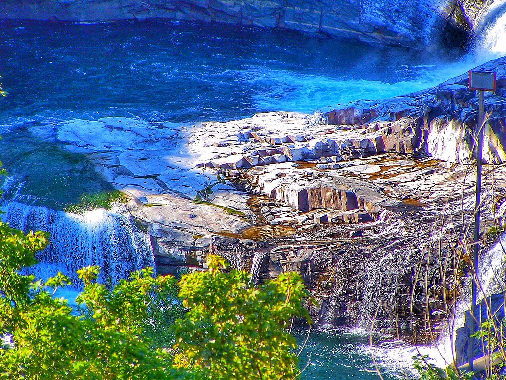
About Twin Falls
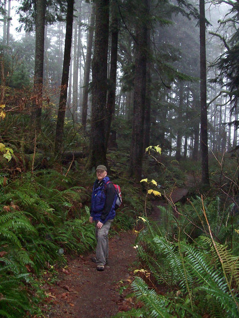
Twin Falls tumbles through a series of moss-draped cascades tucked into the deep forests of Gifford Pinchot National Forest, managed by the U.S. Forest Service. The falls offer classic Pacific Northwest scenery — fern-lined banks, towering evergreens, and multiple viewpoints where the rushing water and spray make for excellent photos and a refreshing day-hike destination. Access is via the U.S. Forest Service’s Table Mountain Trail (Trail #18), which provides a direct, well-defined route to the falls’ viewpoints. The Forest Service’s GIS lists Table Mountain Trail #18 at 1.24 miles, while the commonly used out-and-back route to the falls measures about 3.6 miles round-trip with roughly 500 feet of elevation gain and a moderate difficulty rating, making it a popular option for hikers seeking a relatively short outing in outstanding forest scenery.
The Setting
Twin Falls sits at 2,661 feet within Gifford Pinchot National Forest, fed by the Cispus River, in the hills of Washington.
Trail & Hike Details
The Approach
The moderate hike follows Table Mountain (#18), a 3.6-mile out-and-back trail over natural surface. Expect 500 feet of elevation gain with grades of 12-20%. The trail is developed (Class 3).
USFS Trail
TABLE MOUNTAIN #18
Trail Class
Developed
Surface
Avg Grade
USFS Segment
1.24 miTrail Description
Table Mountain Trail (USFS Trail #18) — Class 3; surface: NAT (native material); typical grade: 12–20%; USFS GIS length: 1.24 miles. The route used by most visitors is a 3.6-mile out-and-back with approximately 500 ft of elevation gain and a moderate overall difficulty. Expect natural tread (roots, packed soil and occasional rocky sections) with short steep pitches in the 12–20% range; proper footwear and steady footing are recommended for the steeper Class 3 sections.
What to Expect
Dogs are welcome.
Accessibility
The trail is not wheelchair accessible. Uneven terrain and elevation changes require steady footing.
Frequently Asked Questions
🐶 Are Dogs Allowed at Twin Falls?
✅ Dogs are allowed
Are There Any Fees or Permits Required?
🤑 Fee: $10.00
Permit required
A Discover Pass is required for parking at the trailhead. Passes can be purchased online or at nearby vendors.
🏊 Is There Swimming at Twin Falls?
❌ Swimming is not allowed
When to Visit
Spring is an excellent time to visit when the waterfall flow is at its peak due to snowmelt. Summer and fall are also great for hiking, with pleasant weather and vibrant foliage. Winter visits are possible but may require extra caution due to icy or muddy trail conditions.
Seasonal Access
The best time to visit is Spring, Summer, Fall, and Winter. Check with Gifford Pinchot National Forest for seasonal road closures.
Safety Information
The trail can be slippery, especially after rain or during winter. Stay on marked paths and avoid getting too close to the edge near the falls. Carry a map or use a GPS device as cell service may be limited.
Current Water Conditions
Based on a USGS gauge 17.8 miles away
520 ft³/s
Current discharge — how much water is flowing
Much lower than usual for this time of year
Based on 29 years of record
13.59 ft
Water depth at gauge
7-Day Discharge Trend
What does this mean for your visit?
Flow is well below normal for this time of year, so the waterfall may be a trickle.
About This Gauge
This gauge is on a regional waterway. Conditions at the falls may differ, especially after local rain.
7-Day Flow Outlook
Based on the USGS gauge CISPUS RIVER AB YELLOWJACKET CREEK NEAR RANDLE, WA (29 km away).
Today
Low
562 cfs
4/10Tomorrow
Low
572 cfs
4/10Sun
Low
552 cfs
4/10Mon
Low
546 cfs
4/10Tue
Low
512 cfs
4/10Wed
Low
503 cfs
4/10Thu
Low
497 cfs
4/10Best window: Today — low flow, rain showers (trip score 4/10).
Best time of year: this gauge typically runs highest from early April to late June, peaking in June.
How we calculate this
This is a transparent outlook, not a precise forecast. We take the waterfall's current flow strength (how it ranks against its historical normal for today, from the nearest USGS stream gauge), carry that ranking forward along the gauge's seasonal curve, and nudge it for forecast rain. Confidence is highest for the next day or two and falls further out. Always check official conditions and your own judgment before visiting — high flows can be dangerous.
Know when to go.
Get a free email alert when waterfalls near Trout Lake hit peak flow. We only send when conditions are worth the trip — no weekly newsletters, no spam.
Weather Forecast
Location & Access
Getting There
Twin Falls is located off Interstate 90, near North Bend, Washington. Take Exit 34 and follow 468th Avenue SE to the Twin Falls Trailhead parking lot.
Get Directions on Google MapsParking
There is a designated parking lot at the Twin Falls Trailhead. A Discover Pass is required for parking.
Elevation
2,661 feet above sea level
Coordinates
46.214840° N, -121.667862° W
Land Management
Managed by USFS
Visitor Tips & Gear
Arrive early to secure parking, especially on weekends. Wear sturdy hiking shoes as the trail can be muddy in wet conditions. Bring water and snacks, and consider visiting during weekdays for a quieter experience.
As an Amazon Associate, we earn from qualifying purchases.
With 3.6 miles and 500 ft of elevation gain, sturdy boots and trekking poles will help on this moderate trail. Icy conditions are common in winter — traction cleats are a smart addition.

Columbia Watertight II Rain Jacket
Packs into its own pocket, seam-sealed, and keeps you dry from spray and surprise rain.

Polarized Sunglasses (Knockaround)
Cuts glare off the water so you actually see the falls — and your photos turn out better too.

Earth Pak Waterproof Dry Bag
Keeps your phone and gear dry when waterfall mist soaks everything else.

Waterproof Phone Pouch (AiRunTech)
Cheap insurance — take photos right next to the falls without killing your phone.

Timberland Euro Sprint Mid Waterproof
Trusted waterproof boot with premium leather and grippy rubber sole — reliable on rocky, wet trails.

TrailBuddy Trekking Poles
Lightweight aluminum, cork grips, and flip-locks that actually hold — a best-seller for good reason.
Where to Stay

Lone Fir Resort

Explore Mt St Helens A-Frame Chalet with Deck!

Rustic Cougar Cabin with Wood-Burning Fire Pit!
Browse vacation cabins and private rentals nearby
Unique outdoor stays — tents, yurts, and treehouses
Rent a campervan or RV for your waterfall road trip
Some links are affiliate links. We may earn a commission at no extra cost to you.
Nearby Campground
LOWER FALLS CAMPGROUND
10.8 miles away · 44 sites
Overview Lower Falls Campground is located in the Gifford Pinchot National Forest. Visitors enjoy several waterfalls in the area and access to the Lewis River Trail. The campground is open from mid-May through October.Recreation Near the campground are several trailheads that provide visitors with a variety of recreational opportunities. There are hiking trails, mountain bike trails, horse trails, and motorcycle trails within 10 miles of the campground. The Lewis River contains rainbow, cutthroat
Book on Recreation.govNearby Hot Springs
Hot springs near Trout Lake, Washington

Mount Adams Fumaroles
Mount Adams fumaroles reach 150 degrees at 12,269 feet elevation, emerging 136 degrees above ambient on Washington's second-hig...
Orr Creek Warm Springs
Orr Creek Warm Springs emerges at 72 degrees in the Gifford Pinchot National Forest at 2,910 feet elevation, flowing 26.5 degre...
Packwood Hot Spring
Packwood Hot Spring flows at 100 degrees at 1,002 feet elevation in the lower Cascade foothills near Morton, emerging 49.8 degr...

Mt St Helens Fumaroles
Mount St. Helens fumaroles reach 190 degrees at 6,906 feet elevation on the crater rim, emerging 159.1 degrees above ambient in...

Collins Hot Springs
Collins Hot Springs emerges at 122 degrees just 127 feet above sea level in the Columbia River Gorge, producing water 68.4 degr...
Fish Hatchery Warm Spring
Fish Hatchery Warm Spring produces 75-degree water on Yakama Nation Reservation lands, flowing 23.7 degrees above ambient tempe...
Looking for a soak after your hike? Explore more hot springs near Trout Lake, Washington on SoakingSprings.
Explore Washington springsAdditional Information
Nearby Attractions
Nearby attractions include Rattlesnake Ledge, Snoqualmie Falls, and Mount Si, all offering additional hiking opportunities and scenic views.
Wildlife
The area is home to various wildlife, including birds, deer, and small mammals. Keep an eye out for salmon in the river during spawning season.
Cities near Twin Falls
Nearby Waterfalls
Other waterfalls named Twin Falls
21 other waterfalls share this name across the U.S.
Writing about Twin Falls? Embed this waterfall on your site for free.