Kettle Falls
Ontario • Sturgeon River Provincial Park • 26 m
By Armen Suny · Last verified Jun 2026
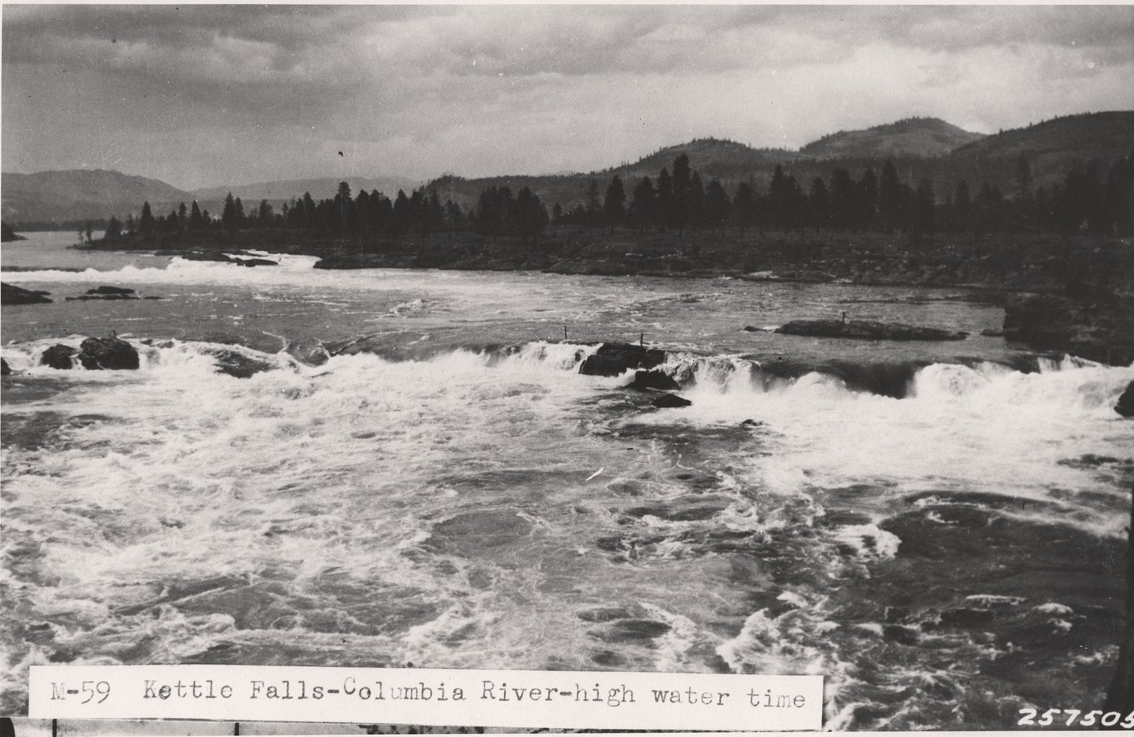
Photo Credits (5)
Difficulty
Moderate
About Kettle Falls
Kettle Falls is a remote waterfall site in northeastern Ontario (coordinates 47.1123, -80.6942) set in boreal forest and rocky Canadian Shield terrain. The falls are in a relatively undeveloped area a few dozen miles from larger towns (Sudbury, Cobalt, New Liskeard). Water flow is typically highest in spring snowmelt and after heavy rains; access can be affected by seasonal road conditions. Specific published measurements for the falls (height and official name usage) are limited or inconsistent in public resources.
The Setting
Kettle Falls sits at 330 metres within Sturgeon River Provincial Park, in the foothills of Ontario. The falls drop 26 metres.
Why This Waterfall Exists
Kettle Falls flows over Lorrain Formation, a layered sedimentary rock layer deposited over 1.6-2.5 billion years ago. These soft rocks erode readily, allowing the stream to carve a 85-foot drop into the landscape.
Trail & Hike Details
Trail Description
Trail access from the parking/pullout is likely a short to moderate walk across uneven, rocky, and rooted terrain typical of the Canadian Shield. Trails in the area may be unmarked or minimally maintained; expect some bushwhacking or a faint footpath. Surfaces can be slippery when wet or icy. Allow extra time for navigation and slow footing.
What to Expect
The falls cascade 26 metres over layered sedimentary rock.
Accessibility
The trail is not wheelchair accessible. Uneven terrain and elevation changes require steady footing.
Frequently Asked Questions
🐶 Are Dogs Allowed at Kettle Falls?
❌ Dogs are not allowed
Are There Any Fees or Permits Required?
🆖 No fees required
🏊 Is There Swimming at Kettle Falls?
❌ Swimming is not allowed
When to Visit
Late spring for highest flows and dramatic water volume; early fall for fall colors and lower crowds. Summer offers warmer conditions but potentially lower flows. Winter access may be difficult and the site may be icy or snow-covered; only attempt winter visits with appropriate winter gear and experience.
Seasonal Access
The best time to visit is Spring, Summer, and Fall. Winter access may be limited. Check with Sturgeon River Provincial Park for current conditions.
Safety Information
Primary hazards: slippery rock and cliff edges, cold water and strong currents near the falls, uneven and exposed terrain, limited cell service, and potential for encountering wildlife. Seasonal hazards include logging traffic on access roads, washouts, and deep snow or ice in winter. Always check local conditions, avoid getting too close to the edge, and never dive or jump into water without a full safety assessment.
Current Water Conditions
5.8 m³/s
Current discharge — how much water is flowing
About average for this time of year
Based on 39 years of record
4.57 m
Water depth at gauge
7-Day Discharge Trend
What does this mean for your visit?
Flow is about average for this time of year.
About This Gauge
This gauge is on a nearby waterway and may not reflect exact conditions at the falls.
7-Day Flow Outlook
Based on the WSC gauge STURGEON RIVER AT UPPER GOOSE FALLS (24 km away).
Today
Moderate
5.7 m³/s
6/10Tomorrow
Moderate
6.0 m³/s
5/10Tue
Moderate
6.6 m³/s
6/10Wed
Moderate
5.7 m³/s
6/10Thu
Moderate
5.5 m³/s
5/10Fri
Moderate
5.0 m³/s
6/10Sat
Moderate
4.9 m³/s
6/10Best window: Today — moderate flow, cloudy (trip score 6/10).
Best time of year: this gauge typically runs highest from early April to mid June, peaking in May.
How we calculate this
This is a transparent outlook, not a precise forecast. We take the waterfall's current flow strength (how it ranks against its historical normal for today, from the nearest WSC stream gauge), carry that ranking forward along the gauge's seasonal curve, and nudge it for forecast rain. Confidence is highest for the next day or two and falls further out. Always check official conditions and your own judgment before visiting — high flows can be dangerous.
Know when to go.
Get a free email alert when waterfalls near Sudbury hit peak flow. We only send when conditions are worth the trip — no weekly newsletters, no spam.
Weather Forecast
Location & Access
Getting There
Kettle Falls is reached by driving on provincial highways and secondary or forest roads from the nearest towns. Expect a final approach on unpaved logging/forest roads or a short spur road; 4WD or high-clearance vehicles may be recommended in wet seasons. Exact turn-by-turn directions and road names vary by approach, confirm local maps or forestry road notices before travel.
Get Directions on Google MapsParking
Parking is minimal and likely informal (small pullouts or roadside parking). Do not block gates or private driveways. Park only where clearly permitted and avoid narrow shoulders. Expect limited signage and no staffed parking area.
Elevation
330 metres above sea level
Coordinates
47.112344° N, -80.694220° W
Land Management
Managed by Ontario Parks
Visitor Tips & Gear
• Check local forestry/park notices and recent trip reports before going. • Use a high-clearance vehicle for forest roads and avoid driving unprepared after heavy rain. • Wear stiff-soled hiking boots; trails are rocky and can be slippery near the falls. • Carry a printed map or offline GPS, cell coverage may be limited. • Pack out all trash and avoid camping or parking on private property. • Let someone know your route and expected return time in remote areas. • Be bear-aware: carry bear spray where legal and know how to use it.
Where to Stay
Browse vacation cabins and private rentals nearby
Unique outdoor stays — tents, yurts, and treehouses
Rent a campervan or RV for your waterfall road trip
Some links are affiliate links. We may earn a commission at no extra cost to you.
Additional Information
Nearby Attractions
Nearest larger communities include Sudbury (≈41 miles), Cobalt (≈56 miles) and New Liskeard (≈62 miles). The broader region offers lakes, provincial parks, fishing, and canoe routes; check local tourism resources for named parks and trails near your approach route.
Wildlife
Local wildlife may include black bear, moose, white-tailed deer, beavers, otters, and a variety of songbirds and waterfowl. Take normal precautions for wildlife encounters and food storage.
Cities near Kettle Falls
Nearby Waterfalls
Other waterfalls named Kettle Falls
2 other waterfalls share this name across Canada.
Writing about Kettle Falls? Embed this waterfall on your site for free.