Lower Falls
New York • 70 ft
By Armen Suny · Last verified Mar 2026
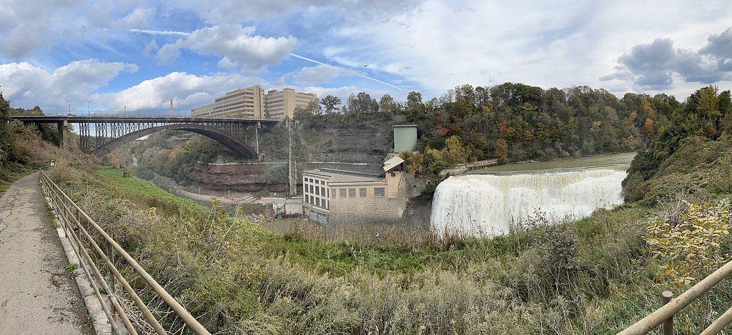
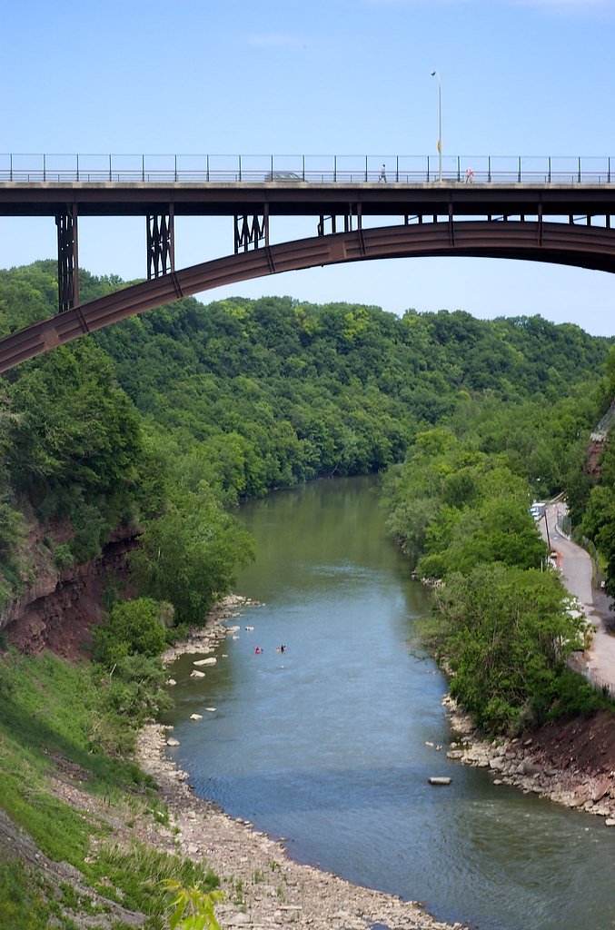

Photo Credits (5)
Difficulty
Moderate
Trail Length
1.0 miles
Trail Type
Out And Back
Elevation Gain
200 ft
About Lower Falls
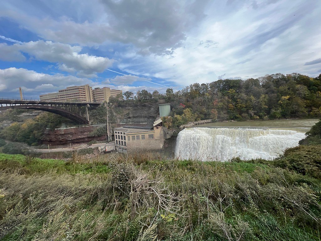
Lower Falls is a stunning waterfall located in Letchworth State Park, New York, often referred to as the 'Grand Canyon of the East.' It is one of three major waterfalls along the Genesee River within the park and is known for its picturesque setting and dramatic cascades.
The Setting
Lower Falls sits at 253 feet along the Genesee River, in the coastal lowlands of New York. The falls drop 70 feet.
Height: 70 feet
Trail & Hike Details
The Approach
The moderate 1.0-mile out-and-back trail gains 200 feet of elevation on the way to the falls.
Trail Description
The trail to Lower Falls is a moderately challenging hike that includes some stairs and uneven terrain. The path offers scenic views of the Genesee River and surrounding gorge. Visitors will cross a stone bridge to get closer to the falls, providing excellent photo opportunities.
What to Expect
The falls drop 70 feet. Dogs are welcome.
Accessibility
The trail is not wheelchair accessible. Uneven terrain and elevation changes require steady footing.
Frequently Asked Questions
🐶 Are Dogs Allowed at Lower Falls?
✅ Dogs are allowed
Are There Any Fees or Permits Required?
🤑 Fee: $10.00
🏊 Is There Swimming at Lower Falls?
❌ Swimming is not allowed
When to Visit
Spring and early summer are ideal times to visit, as the waterfall flow is strongest due to snowmelt and rainfall. Fall offers beautiful foliage, making it another popular season.
Seasonal Access
The best time to visit is Spring, Summer, and Fall. Winter access may be limited.
Safety Information
The trail can be slippery, especially after rain. Stay on marked paths and avoid getting too close to the edge of the gorge. Supervise children closely.
Current Water Conditions
826 ft³/s
Current discharge — how much water is flowing
About average for this time of year
Based on 74 years of record
12.71 ft
Water depth at gauge
73°F
ComfortablePleasant for swimming
7-Day Discharge Trend
What does this mean for your visit?
Flow is about average for this time of year. The water is a comfortable 73 degrees F, pleasant for swimming. Expect slightly cloudy visibility and excellent dissolved oxygen levels. PH is normal at 8.0 and mineral content is moderate.
Water Quality
Dissolved Oxygen
ExcellentSupports aquatic life
pH
NormalWithin healthy range (6.5-8.5)
Water Clarity
Slightly cloudyMinor sediment present
Conductance
Dissolved minerals in the water
About This Gauge
7-Day Flow Outlook
Based on the USGS gauge GENESEE RIVER AT FORD STREET BRIDGE, ROCHESTER NY (4 km away).
Today
Barely Flowing
826 cfs
5/10Tomorrow
Low
842 cfs
3/10Thu
Low
907 cfs
3/10Fri
Barely Flowing
696 cfs
5/10Sat
Low
675 cfs
3/10Sun
Low
780 cfs
3/10Mon
Low
737 cfs
3/10Best window: Today — barely flowing flow, mostly sunny (trip score 5/10).
Best time of year: this gauge typically runs highest from late February to early May, peaking in April.
How we calculate this
This is a transparent outlook, not a precise forecast. We take the waterfall's current flow strength (how it ranks against its historical normal for today, from the nearest USGS stream gauge), carry that ranking forward along the gauge's seasonal curve, and nudge it for forecast rain. Confidence is highest for the next day or two and falls further out. Always check official conditions and your own judgment before visiting — high flows can be dangerous.
Know when to go.
Get a free email alert when waterfalls near Rochester hit peak flow. We only send when conditions are worth the trip — no weekly newsletters, no spam.
Weather Forecast
Location & Access
Getting There
Lower Falls is located within Letchworth State Park, which is accessible via multiple entrances. The waterfall is near the southern end of the park, and visitors can follow signs to the Lower Falls area.
Get Directions on Google MapsParking
Parking is available near the Lower Falls trailhead. The parking lot is well-marked and located within walking distance of the trail leading to the falls.
Elevation
253 feet above sea level
Coordinates
43.179570° N, -77.627960° W
Visitor Tips & Gear
Arrive early during peak seasons to secure parking and avoid crowds. Wear sturdy footwear, as the trail includes stairs and uneven surfaces. Bring water and a camera to capture the stunning scenery.
As an Amazon Associate, we earn from qualifying purchases.
With 1.0 miles and 200 ft of elevation gain, sturdy boots and trekking poles will help on this moderate trail. Sun exposure on the trail makes good sun protection a must in summer.

Polarized Sunglasses (Knockaround)
Cuts glare off the water so you actually see the falls — and your photos turn out better too.

Columbia Watertight II Rain Jacket
Packs into its own pocket, seam-sealed, and keeps you dry from spray and surprise rain.

Earth Pak Waterproof Dry Bag
Keeps your phone and gear dry when waterfall mist soaks everything else.

Waterproof Phone Pouch (AiRunTech)
Cheap insurance — take photos right next to the falls without killing your phone.

Timberland Euro Sprint Mid Waterproof
Trusted waterproof boot with premium leather and grippy rubber sole — reliable on rocky, wet trails.

TrailBuddy Trekking Poles
Lightweight aluminum, cork grips, and flip-locks that actually hold — a best-seller for good reason.
Where to Stay

Country Inn & Suites by Radisson, Rochester-Pittsford-Brighton, NY

Hampton Inn Rochester - Irondequoit

Inn on Broadway

Spark By Hilton Rochester University Area
Browse vacation cabins and private rentals nearby
Unique outdoor stays — tents, yurts, and treehouses
Rent a campervan or RV for your waterfall road trip
Some links are affiliate links. We may earn a commission at no extra cost to you.
Additional Information
Nearby Attractions
Other waterfalls in Letchworth State Park, including Middle Falls and Upper Falls. The park also offers hiking trails, picnic areas, and a visitor center.
Wildlife
The park is home to deer, foxes, and a variety of bird species, including bald eagles.
Cities near Lower Falls
Nearby Waterfalls
 CC
CC
Other waterfalls named Lower Falls
19 other waterfalls share this name across the U.S.
Writing about Lower Falls? Embed this waterfall on your site for free.