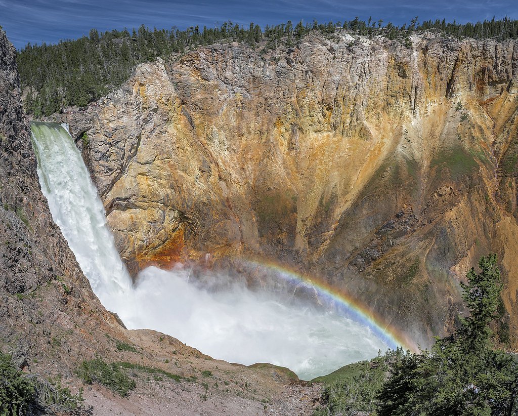
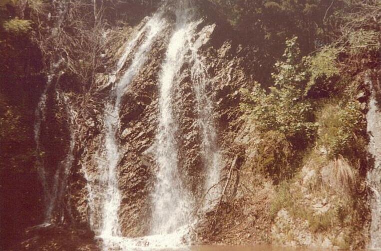
Lower Falls
Montana • 308 ft
By Armen Suny · Last verified Mar 2026
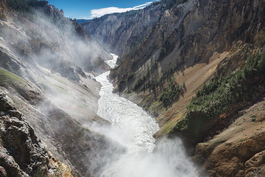
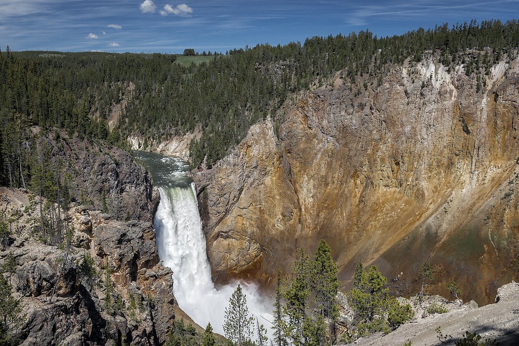
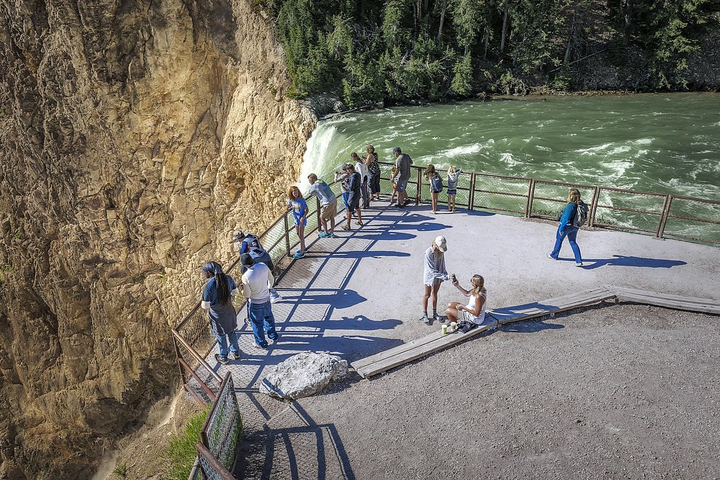
Photo Credits (5)
Difficulty
Moderate
Trail Length
0.7 miles
Trail Type
Out And Back
Elevation Gain
500 ft
About Lower Falls
Lower Falls is an impressive 308-foot cascade tucked into the rugged forests of Kootenai National Forest in northwest Montana, managed by the U.S. Forest Service. The drop is dramatic and framed by steep canyon walls and dense native timber, making the falls a rewarding destination for hikers willing to tackle a short, energetic approach. The setting feels remote and alive — ideal for photographers and day hikers seeking a powerful waterfall without a long backcountry trek. Access is provided via the USFS-maintained WEST FORK YAAK FALLS (Trail #176). The hiking route is a compact out-and-back that climbs steadily to a viewpoint near the base of the falls; with 500 feet of elevation gain over roughly 0.7 miles the outing is rated moderate. If you’re camping, Garver Mtn. Lookout Rental is the nearest option at about 8.32 km away, offering a convenient base for an early-morning visit to avoid crowds and catch the best light on the falls.
The Setting
Lower Falls sits at 3,123 feet within Kootenai National Forest, fed by the Tobacco River, in the mountains of Montana. At 308 feet, it is among the taller waterfalls in Montana.
Height: 308 feet
Trail & Hike Details
The Approach
The moderate hike follows West Fork Yaak Falls (#176), a 0.7-mile out-and-back trail over natural surface. Expect 500 feet of elevation gain with grades of 12-20%. The trail is highly developed (Class 4).
USFS Trail
WEST FORK YAAK FALLS #176
Trail Class
Highly Developed
Surface
Avg Grade
USFS Segment
0.23 miTrail Description
Trail: WEST FORK YAAK FALLS, Trail #176 (USFS). Trail type: out-and-back; trail length: 0.7 miles; elevation gain: 500 ft; difficulty: moderate. Surface: native material with a typically steady grade of 12–20%. USFS records list the trail with 0.23 GIS miles and classify it as Class 4, indicating short steep or exposed sections and more rugged tread. Expect a short but sustained climb on uneven, natural footing — stout shoes and sure footing are recommended for the descent to viewpoints near the 308-foot Lower Falls.
What to Expect
The falls plunge a dramatic 308 feet.
Accessibility
The trail is not wheelchair accessible. Uneven terrain and elevation changes require steady footing.
Frequently Asked Questions
🐶 Are Dogs Allowed at Lower Falls?
❌ Dogs are not allowed
Are There Any Fees or Permits Required?
🤑 Fee: $35.00
🏊 Is There Swimming at Lower Falls?
❌ Swimming is not allowed
When to Visit
The best time to visit is during late spring and summer when the snowmelt increases the water flow, creating a more dramatic waterfall. Fall offers beautiful foliage, while winter provides a unique, icy perspective.
Seasonal Access
The best time to visit is Spring, Summer, and Fall. Winter access may be limited. Check with Kootenai National Forest for seasonal road closures.
Safety Information
Stay on designated trails and away from cliff edges. The stairs on Uncle Tom's Trail can be slippery, especially when wet. Be cautious of wildlife and changing weather conditions.
Current Water Conditions
Based on a USGS gauge 28.8 miles away
363 ft³/s
Current discharge — how much water is flowing
About average for this time of year
Based on 10 years of record
3.35 ft
Water depth at gauge
7-Day Discharge Trend
What does this mean for your visit?
Flow is about average for this time of year.
About This Gauge
This gauge is on a regional waterway. Conditions at the falls may differ, especially after local rain.
7-Day Flow Outlook
Based on the USGS gauge Tobacco River at Eureka, MT (46 km away).
Today
Low
414 cfs
3/10Tomorrow
Moderate
430 cfs
4/10Mon
Moderate
409 cfs
4/10Tue
Moderate
379 cfs
5/10Wed
Low
317 cfs
6/10Thu
Low
290 cfs
6/10Fri
Low
307 cfs
4/10Best window: Wed — low flow, mostly sunny (trip score 6/10).
Best time of year: this gauge typically runs highest from early April to early July, peaking in May.
How we calculate this
This is a transparent outlook, not a precise forecast. We take the waterfall's current flow strength (how it ranks against its historical normal for today, from the nearest USGS stream gauge), carry that ranking forward along the gauge's seasonal curve, and nudge it for forecast rain. Confidence is highest for the next day or two and falls further out. Always check official conditions and your own judgment before visiting — high flows can be dangerous.
Know when to go.
Get a free email alert when waterfalls near Yaak hit peak flow. We only send when conditions are worth the trip — no weekly newsletters, no spam.
Weather Forecast
Location & Access
Getting There
Lower Falls can be accessed via the South Rim Drive or North Rim Drive within Yellowstone National Park. The falls are visible from several viewpoints, including Artist Point, Lookout Point, and Uncle Tom's Trail.
Get Directions on Google MapsParking
Parking is available at designated lots near the viewpoints, such as Artist Point and Lookout Point. These lots can fill up quickly during peak seasons.
Elevation
3,123 feet above sea level
Coordinates
48.935512° N, -115.681575° W
Land Management
Managed by USFS
Visitor Tips & Gear
Arrive early in the day to secure parking and avoid crowds. Wear sturdy shoes if hiking Uncle Tom's Trail, and bring water. Be prepared for changing weather conditions, as temperatures can vary significantly.
As an Amazon Associate, we earn from qualifying purchases.
With 0.7 miles and 500 ft of elevation gain, sturdy boots and trekking poles will help on this moderate trail. Sun exposure on the trail makes good sun protection a must in summer.

Polarized Sunglasses (Knockaround)
Cuts glare off the water so you actually see the falls — and your photos turn out better too.

Columbia Watertight II Rain Jacket
Packs into its own pocket, seam-sealed, and keeps you dry from spray and surprise rain.

Earth Pak Waterproof Dry Bag
Keeps your phone and gear dry when waterfall mist soaks everything else.

Waterproof Phone Pouch (AiRunTech)
Cheap insurance — take photos right next to the falls without killing your phone.

Timberland Euro Sprint Mid Waterproof
Trusted waterproof boot with premium leather and grippy rubber sole — reliable on rocky, wet trails.

TrailBuddy Trekking Poles
Lightweight aluminum, cork grips, and flip-locks that actually hold — a best-seller for good reason.
Where to Stay

Quiet Log Cabin • Gazebo • Near River & Trails

Log Inn Bonners Ferry

North Haven Campground

Northside School Bed & Breakfast
Browse vacation cabins and private rentals nearby
Unique outdoor stays — tents, yurts, and treehouses
Rent a campervan or RV for your waterfall road trip
Some links are affiliate links. We may earn a commission at no extra cost to you.
Nearby Campground
GARVER MTN. LOOKOUT RENTAL
5.2 miles away · 1 sites
Overview Garver Mountain Lookout is perched on top of Garver Mountain at an elevation of 5,874 feet. The lookout is located in the Yaak area of the Kootenai National Forest, characterized by its minimal services and rugged beauty. This destination is ideal for visitors with an adventurous attitude, looking for a plethora of outdoor activities. Garver Mountain Lookout has been used as an observation point for detecting forest fires since 1929. The first lookout was a one-story log cabin, which is
Book on Recreation.govAdditional Information
Nearby Attractions
Other attractions in the Grand Canyon of the Yellowstone include Upper Falls, Artist Point, and Inspiration Point.
Wildlife
The area is home to diverse wildlife, including bison, elk, and occasionally bears. Keep a safe distance from all animals.
Cities near Lower Falls
Nearby Waterfalls

Other waterfalls named Lower Falls
19 other waterfalls share this name across the U.S.
Writing about Lower Falls? Embed this waterfall on your site for free.