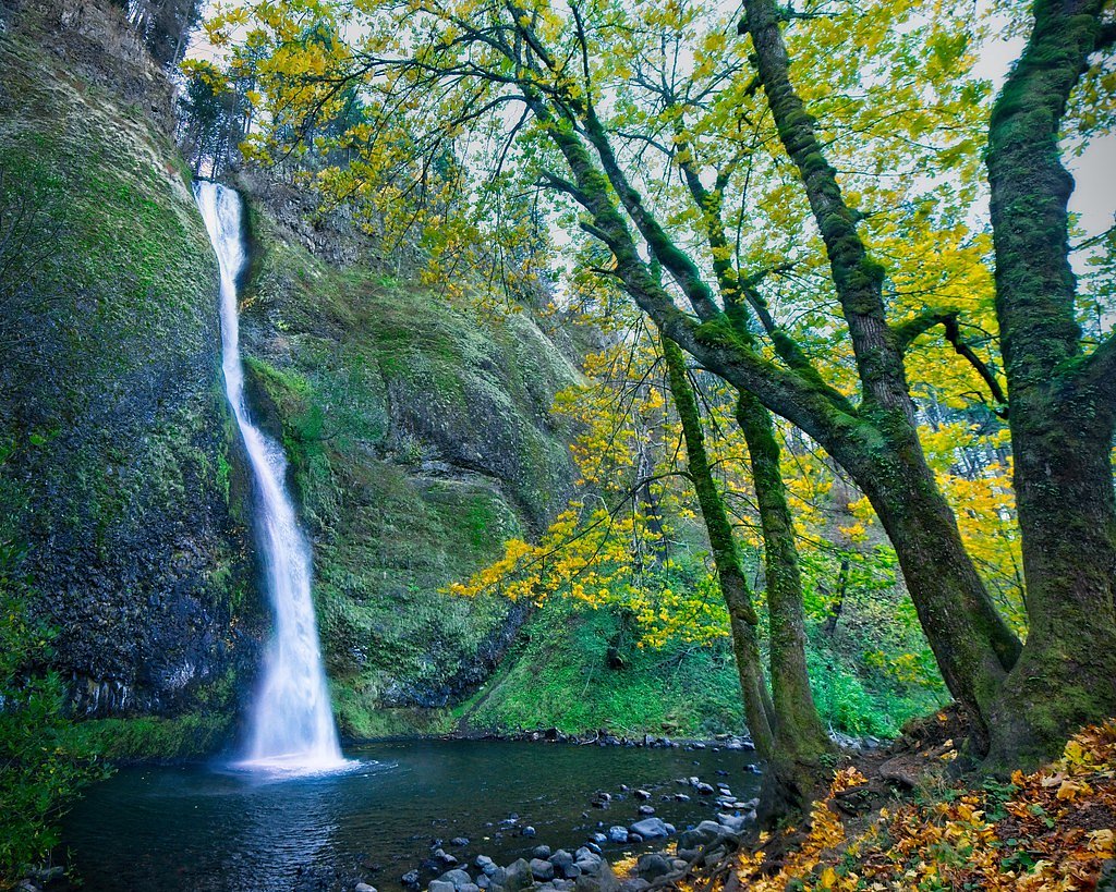
Horseshoe Falls
By Armen Suny · Last verified Mar 2026
Photo Credits (5)
Difficulty
Moderate
Trail Length
2.4 miles
Trail Type
Out And Back
Elevation Gain
350 ft
About Horseshoe Falls
Horseshoe Falls is a small, seasonal cascade tucked into Oregon’s high desert near Grass Valley, Moro, and Wasco. When spring runoff is strong the stream fans into a distinctive horseshoe-shaped curtain of water that contrasts dramatically with the stark, arid basalt and sagebrush slopes around it. The setting is quintessential Central Oregon high desert — wide views, rugged rock, and a quieter, more withdrawn waterfall experience than the rainforest falls on the coast or western Cascades. The falls and access lie on public lands managed by the Bureau of Land Management’s Prineville (Central Oregon) Field Office, so visitors should treat the area with Leave No Trace principles in mind. The nearest developed camping is Macks Canyon Recreation Site, roughly 23 km (about 14 miles) away, so plan accordingly for water and supplies. Horseshoe Falls rewards a short outing with big, open-sky scenery and a seasonal splash that’s best visited in spring and early summer.
The Setting
Horseshoe Falls sits at 1,470 feet within Prineville Central Oregon Field Office, fed by the John Day River, in the foothills of Oregon.
Trail & Hike Details
The Approach
The moderate 2.4-mile out-and-back trail gains 350 feet of elevation on the way to the falls.
Trail Description
This route is an out-and-back roughly 2.4 miles in length with about 350 feet of elevation gain, rated moderate. The trail type is out-and-back; there is no USFS trail number because the feature and route are on BLM-managed public land. Trail conditions can include uneven, natural terrain and informal use paths, so expect some off-trail navigation and wear sturdy footwear and sun protection. Detailed surface, grade, and USFS-class data are not documented for this BLM route.
What to Expect
Horseshoe Falls is a seasonal waterfall that may not flow during the dry months of summer and fall. When active, it offers a picturesque view of water cascading in a horseshoe shape. The surrounding area is characterized by high desert vegetation and open landscapes.
Accessibility
The trail is not wheelchair accessible. Uneven terrain and elevation changes require steady footing.
Frequently Asked Questions
🐶 Are Dogs Allowed at Horseshoe Falls?
❌ Dogs are not allowed
Are There Any Fees or Permits Required?
🆖 No fees required
🏊 Is There Swimming at Horseshoe Falls?
❌ Swimming is not allowed
When to Visit
The best time to visit Horseshoe Falls is during the spring or early summer when water flow is most likely to be present.
Seasonal Access
The best time to visit is Spring, Summer, and Fall. Winter access may be limited.
Safety Information
Visitors should be cautious of uneven terrain, potential wildlife encounters, and the remote location. Bring sufficient water and inform someone of your plans before visiting.
Current Water Conditions
Based on a USGS gauge 16.3 miles away
205 ft³/s
Current discharge — how much water is flowing
Much lower than usual for this time of year
Based on 119 years of record
2.16 ft
Water depth at gauge
80°F
ComfortablePleasant for swimming
7-Day Discharge Trend
What does this mean for your visit?
Flow is well below normal for this time of year, so the waterfall may be a trickle. The water is a comfortable 80 degrees F, pleasant for swimming.
About This Gauge
This gauge is on a regional waterway. Conditions at the falls may differ, especially after local rain.
7-Day Flow Outlook
Based on the USGS gauge JOHN DAY RIVER AT MCDONALD FERRY, OR (26 km away).
Today
Barely Flowing
205 cfs
5/10Tomorrow
Barely Flowing
192 cfs
4/10Fri
Barely Flowing
202 cfs
3/10Sat
Barely Flowing
187 cfs
5/10Sun
Barely Flowing
170 cfs
5/10Mon
Barely Flowing
162 cfs
5/10Tue
Barely Flowing
156 cfs
5/10Best window: Today — barely flowing flow, mostly sunny (trip score 5/10).
Best time of year: this gauge typically runs highest from mid March to mid June, peaking in April.
How we calculate this
This is a transparent outlook, not a precise forecast. We take the waterfall's current flow strength (how it ranks against its historical normal for today, from the nearest USGS stream gauge), carry that ranking forward along the gauge's seasonal curve, and nudge it for forecast rain. Confidence is highest for the next day or two and falls further out. Always check official conditions and your own judgment before visiting — high flows can be dangerous.
Know when to go.
Get a free email alert when waterfalls near Grass Valley hit peak flow. We only send when conditions are worth the trip — no weekly newsletters, no spam.
Weather Forecast
Location & Access
Getting There
Horseshoe Falls is located approximately 9.8 miles from Grass Valley, Oregon. Visitors can use GPS coordinates 45.3874, -120.5856 to navigate to the site. The waterfall is situated in a remote area, and access may require driving on unpaved roads. It is recommended to check local conditions before visiting.
Get Directions on Google MapsParking
Parking availability is unclear, but visitors may need to park along the roadside or in a small pullout area near the waterfall.
Elevation
1,470 feet above sea level
Coordinates
45.387382° N, -120.585644° W
Land Management
Managed by BLM
Visitor Tips & Gear
Check local weather and water flow conditions before visiting, as the waterfall may be dry during certain times of the year. Bring plenty of water and sun protection, as the area can be hot and exposed.
As an Amazon Associate, we earn from qualifying purchases.
With 2.4 miles and 350 ft of elevation gain, sturdy boots and trekking poles will help on this moderate trail. Sun exposure on the trail makes good sun protection a must in summer.

Polarized Sunglasses (Knockaround)
Cuts glare off the water so you actually see the falls — and your photos turn out better too.

Columbia Watertight II Rain Jacket
Packs into its own pocket, seam-sealed, and keeps you dry from spray and surprise rain.

Earth Pak Waterproof Dry Bag
Keeps your phone and gear dry when waterfall mist soaks everything else.

Waterproof Phone Pouch (AiRunTech)
Cheap insurance — take photos right next to the falls without killing your phone.

Timberland Euro Sprint Mid Waterproof
Trusted waterproof boot with premium leather and grippy rubber sole — reliable on rocky, wet trails.

TrailBuddy Trekking Poles
Lightweight aluminum, cork grips, and flip-locks that actually hold — a best-seller for good reason.
Where to Stay

Balch Hotel

Holiday Inn Express & Suites - The Dalles by IHG

Columbia River Hotel and Conference Center, an Ascend Collection Hotel

The Dalles Inn
Browse vacation cabins and private rentals nearby
Unique outdoor stays — tents, yurts, and treehouses
Rent a campervan or RV for your waterfall road trip
Some links are affiliate links. We may earn a commission at no extra cost to you.
Nearby Campground
Macks Canyon Recreation Site
14.2 miles away · 0 sites
The Macks Canyon archaeological site is a large, prehistoric village locale overlooking the Deschutes River in north-central Oregon. The site is characterized by shallow, circular, semi-subterranean house depressions, surface artifacts, and riverine shell deposits. Limited excavations conducted in the late 1960's indicate that the site was the location of a winter village occupied by Sahaptin-speaking people of the Columbia Plateau. Although the main period of occupation appears to have occurred
Book on Recreation.govNearby Hot Springs
Hot springs near Grass Valley, Oregon
Klickitat Mineral Springs
Klickitat Mineral Springs produces 81-degree water at just 481 feet elevation on state conservation lands, flowing 27.9 degrees...
Well Spring
Well Spring flows at 80°F at 849 feet in Morrow County near Boardman, creating a 24.7-degree differential above ambient tempera...
Kahneeta Hot Springs
Kahneeta Hot Springs flows at 126°F on Warm Springs Reservation tribal land at 1,450 feet elevation, sitting just 6 meters from...

Springs
These thermal springs emerge at 125°F on sovereign Warm Springs Reservation land in Jefferson County, creating a 72-degree temp...
Fish Hatchery Warm Spring
Fish Hatchery Warm Spring produces 75-degree water on Yakama Nation Reservation lands, flowing 23.7 degrees above ambient tempe...
Looking for a soak after your hike? Explore more hot springs near Grass Valley, Oregon on SoakingSprings.
Explore Oregon springsAdditional Information
Nearby Attractions
The towns of Grass Valley, Moro, and Wasco offer small-town charm and amenities. The surrounding high desert landscape is ideal for photography and exploration.
Wildlife
The area may feature high desert wildlife such as birds, small mammals, and reptiles. Visitors should be cautious of snakes and other potentially hazardous animals.
Cities near Horseshoe Falls
Other waterfalls named Horseshoe Falls
14 other waterfalls share this name across the U.S.
Writing about Horseshoe Falls? Embed this waterfall on your site for free.