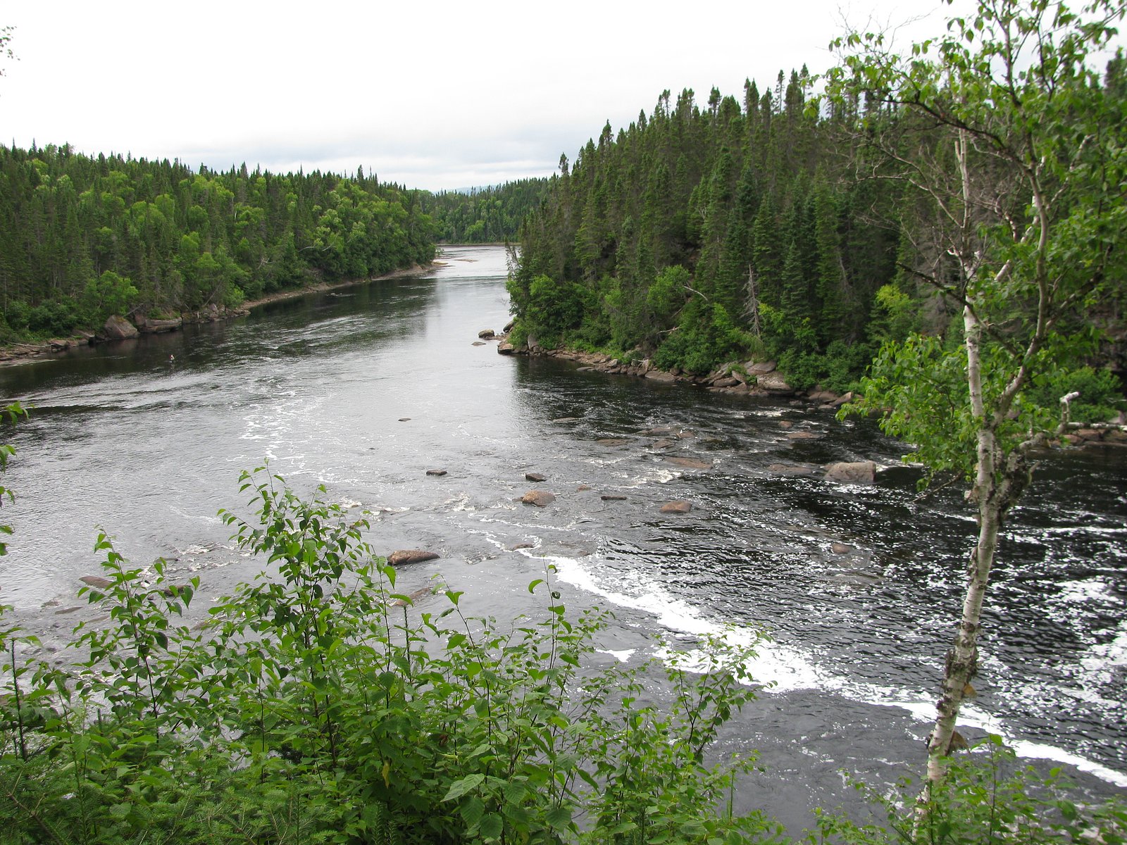
Big Falls
Newfoundland and Labrador • 3 m
By Armen Suny · Last verified Jun 2026
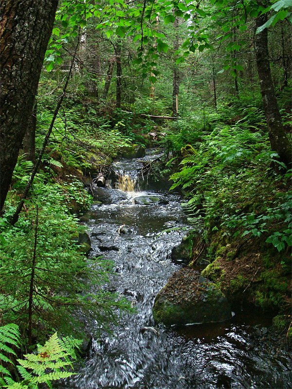
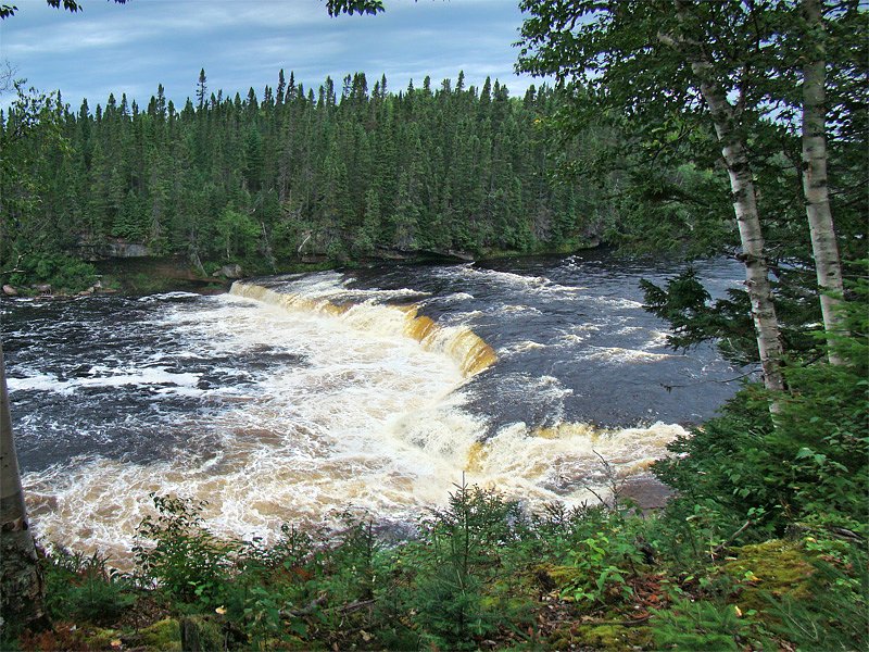
Photo Credits (3)
Difficulty
Easy
Trail Length
0.2 km
Trail Type
Out And Back
About Big Falls
Big Falls is a remote, forested waterfall located in central-western Newfoundland and Labrador near the coordinates 49.3475, -57.1696. It sits in a rugged, wooded landscape typical of the Deer Lake region and is best described as a natural, unserviced site rather than a developed park attraction. Visitor reports suggest the falls are reached via secondary/forestry roads and/or cross-country approaches; there does not appear to be a formally maintained trail or developed viewpoint. Water flow and appearance vary seasonally, with higher flows in spring and after heavy rain.
The Setting
Big Falls sits at 77 metres within Sir Richard Squires Memorial Provincial Park, in the coastal lowlands of Newfoundland and Labrador. The falls drop 3 metres.
Why This Waterfall Exists
Big Falls flows over layered sedimentary rock, primarily sandstone, laid down about 299-359 million years ago. These soft rocks erode readily, allowing the stream to carve a 10-foot drop into the landscape.
Trail & Hike Details
Trail Description
There is no widely documented, maintained trail to Big Falls. Access appears to be via secondary / forestry roads with short off-road approaches that may involve bushwhacking, uneven terrain, wet stream crossings, and steep or slippery banks near the falls. Because maintained trails and signage are not confirmed, expect route-finding, unstable footing, and natural obstacles. Treat this as a backcountry approach and prepare accordingly.
What to Expect
The falls drop a gentle 3 metres over layered sedimentary rock.
Accessibility
The trail is short and relatively flat, but the surface may be uneven. Contact the managing agency for accessibility details.
Frequently Asked Questions
🐶 Are Dogs Allowed at Big Falls?
❌ Dogs are not allowed
Are There Any Fees or Permits Required?
🆖 No fees required
🏊 Is There Swimming at Big Falls?
❌ Swimming is not allowed
When to Visit
Late spring (snowmelt and higher flows) and early summer often offer the most dramatic water flow. Late summer and early fall provide easier ground access and pleasant weather for hiking. Winter access may be possible for experienced winter travelers but will be significantly more difficult and icy; approach only with proper winter gear and experience.
Seasonal Access
The best time to visit is Spring, Summer, and Fall. Winter access may be limited. Check with the managing park or local authority for current conditions.
Safety Information
This is a remote, unserviced waterfall. Hazards include: slippery rocks and steep banks near the falls; strong currents and cold water; unstable or eroding streambanks; uneven or boggy ground on approach; limited or no cell coverage; changing weather conditions; seasonal logging traffic. Travel with a companion if possible, tell someone your plans and expected return time, bring navigation and emergency gear, and avoid getting too close to the edge or attempting technical climbs without proper equipment and experience.
Current Water Conditions
0.1 m³/s
Current discharge — how much water is flowing
About average for this time of year
Based on 40 years of record
0.89 m
Water depth at gauge
7-Day Discharge Trend
What does this mean for your visit?
Flow is about average for this time of year.
About This Gauge
This gauge is on a nearby waterway and may not reflect exact conditions at the falls.
7-Day Flow Outlook
Based on the WSC gauge BOOT BROOK AT TRANS-CANADA HIGHWAY (10 km away).
Today
Moderate
0.1 m³/s
5/10Tomorrow
Moderate
0.1 m³/s
6/10Tue
Moderate
0.1 m³/s
6/10Wed
Moderate
0.1 m³/s
5/10Thu
Moderate
0.1 m³/s
6/10Fri
Moderate
0.1 m³/s
6/10Sat
Moderate
0.1 m³/s
5/10Best window: Tomorrow — moderate flow, light drizzle (trip score 6/10).
Best time of year: this gauge typically runs highest from early April to late May, peaking in May.
How we calculate this
This is a transparent outlook, not a precise forecast. We take the waterfall's current flow strength (how it ranks against its historical normal for today, from the nearest WSC stream gauge), carry that ranking forward along the gauge's seasonal curve, and nudge it for forecast rain. Confidence is highest for the next day or two and falls further out. Always check official conditions and your own judgment before visiting — high flows can be dangerous.
Know when to go.
Get a free email alert when waterfalls near Deer Lake hit peak flow. We only send when conditions are worth the trip — no weekly newsletters, no spam.
Weather Forecast
Location & Access
Getting There
The waterfall is located approximately 19.2 miles (30.9 km) from Deer Lake, 38.8 miles (62.5 km) from Buchans, and 46.7 miles (75.1 km) from Trout River (distances provided by the user). Coordinates: 49.3475, -57.1696. Expect to reach the general area by paved roads out of Deer Lake, then on secondary/forestry/logging roads. Some approaches may require a high-clearance vehicle or ATV and/or hiking from the nearest road. There does not appear to be an official trailhead or signage for a developed viewpoint.
Get Directions on Google MapsParking
No official parking area is known. Visitors typically use informal pullouts along forestry or logging roads. Parking may be rough/grassy and could be limited; park well off the road and avoid blocking access gates. If uncertain about access roads, check with local authorities or landowners before parking on private property.
Elevation
77 metres above sea level
Coordinates
49.347511° N, -57.169638° W
Land Management
Managed by Government of Newfoundland and Labrador, Department of Tourism, Culture, Arts and Recreation, Parks Division
Visitor Tips & Gear
• Confirm access and road conditions with local information sources (Deer Lake visitor center or local forestry office) before traveling. • Use a high-clearance vehicle for forestry roads; some approaches may require hiking or ATV. • Do not rely on cell service; carry a map, compass, GPS, or satellite communicator. • Wear sturdy, waterproof hiking boots and treat rocky banks as slippery. • Respect private property and posted signs; obtain permission if crossing private land. • Leave no trace: pack out trash and avoid disturbing fragile streambanks and vegetation. • If planning to swim or get in the water, be aware conditions can be cold and currents strong, exercise extreme caution.
Where to Stay
Browse vacation cabins and private rentals nearby
Unique outdoor stays — tents, yurts, and treehouses
Rent a campervan or RV for your waterfall road trip
Some links are affiliate links. We may earn a commission at no extra cost to you.
Nearby Campground
Sir Richard Squires Memorial Provincial Park
0.3 km away
Additional Information
Nearby Attractions
Nearest communities: Deer Lake (nearest town/ services), Buchans and Trout River at greater distances. The Humber Valley region near Deer Lake offers additional outdoor recreation and services. For more developed parks or well-signed attractions, consult provincial tourism resources for the Deer Lake/Humber Valley area.
Wildlife
Typical local wildlife may include moose, black bear, foxes, snowshoe hare, and a variety of bird species. Insects such as black flies and mosquitoes are common in warmer months. Exercise standard wildlife precautions: store food securely, give wildlife distance, and be bear-aware.
Cities near Big Falls
Nearby Waterfalls
Other waterfalls named Big Falls
23 other waterfalls share this name across Canada.
Writing about Big Falls? Embed this waterfall on your site for free.