
Photo Credits (5)
Difficulty
Moderate
Trail Length
2.4 miles
Trail Type
Out And Back
Elevation Gain
350 ft
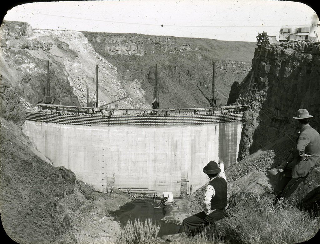
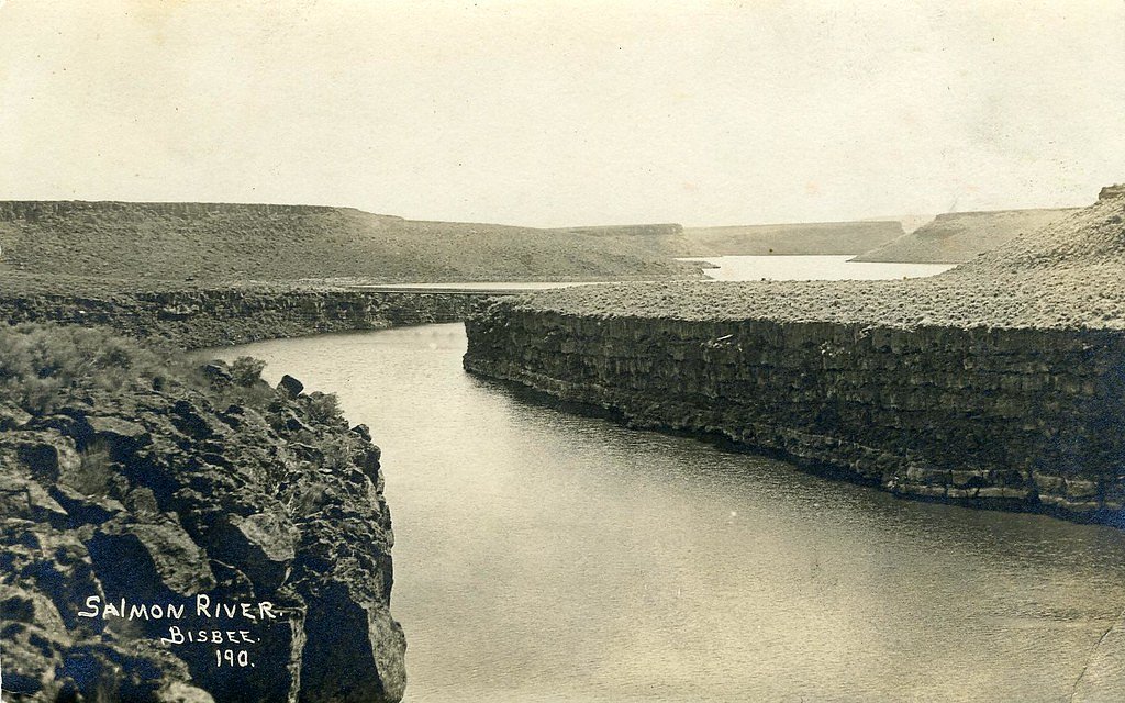
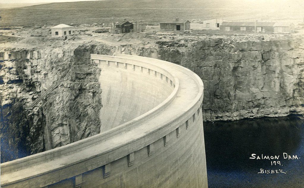
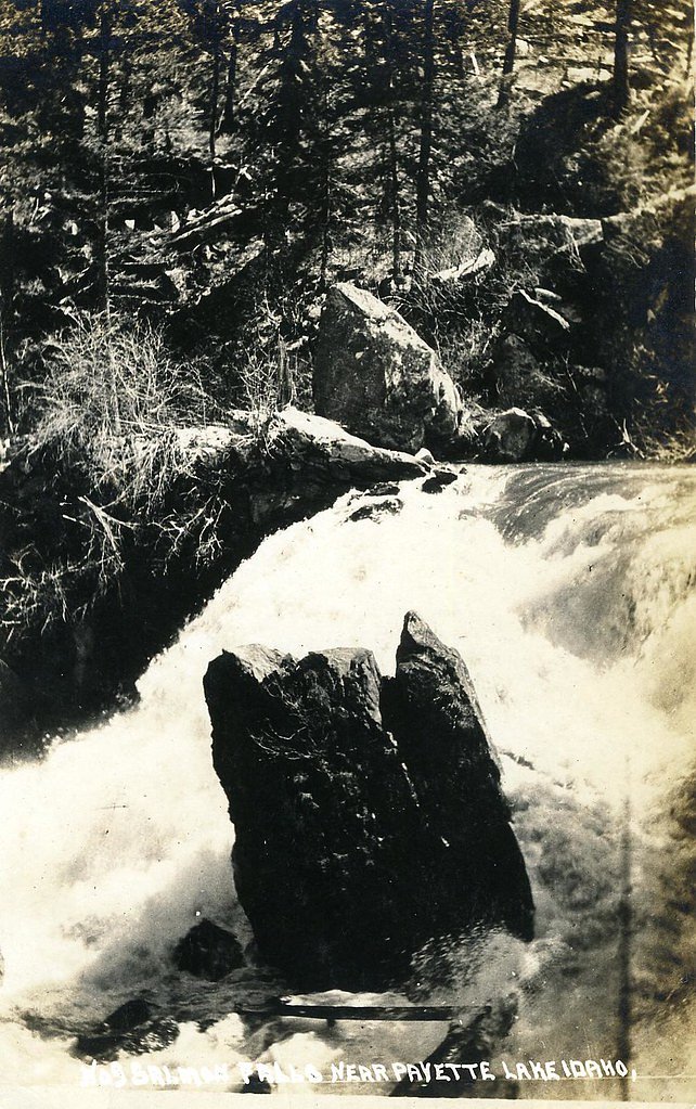
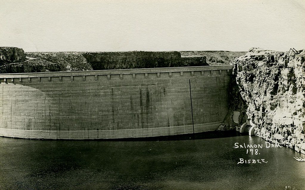
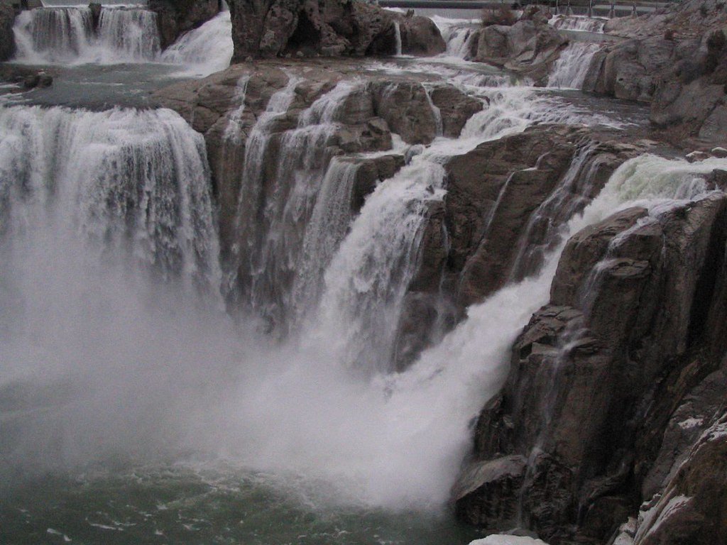
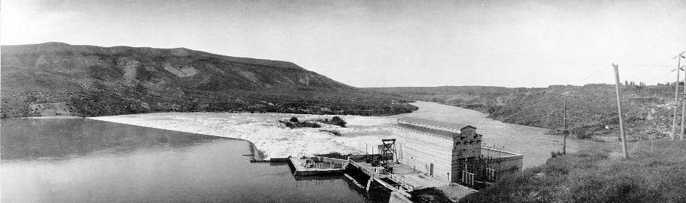
About Salmon Falls
Salmon Falls in Idaho refers to the pair of cascades on the Snake River—commonly called Upper Salmon Falls and Lower Salmon Falls—located near Hagerman. These falls form a striking series along the river and are noted in Wikipedia’s coverage of Idaho’s riverine features; visitors come for broad river views, the rugged canyon setting, and photographic opportunities along the banks. The spot is an easy-to-enjoy natural landmark for anyone exploring southern Idaho’s waterways and volcanic-scarred landscapes. A moderate out-and-back hike accesses viewpoints for the falls: the trail is about 2.4 miles round-trip with roughly 350 feet of elevation gain. Expect a mostly natural route with some short, steeper sections—great for hikers looking for a relatively short outing that still rewards with river vistas and waterfall scenery. Bring water, sturdy shoes, and a camera—the falls and the surrounding river corridor make a memorable half-day excursion.
The Setting
Salmon Falls sits at 2,871 feet along the Salmon Falls Creek, in the hills of Idaho.
Trail & Hike Details
The Approach
The moderate 2.4-mile out-and-back trail gains 350 feet of elevation on the way to the falls.
Trail Description
Trail type: out-and-back. Distance: 2.4 miles (round-trip). Elevation gain: ~350 feet. Difficulty: moderate. The route follows a predominantly natural singletrack and informal riverbank paths to viewpoints of Upper and Lower Salmon Falls on the Snake River near Hagerman. Terrain includes short steeper pitches and uneven footing; trail surface and official USFS trail number/data are not provided in the available sources, so hikers should be prepared for primitive conditions and limited facilities.
What to Expect
Expect stunning views of the waterfall and the surrounding canyon. The area is remote and offers opportunities for photography, fishing, and enjoying the natural beauty of southern Idaho.
Accessibility
The trail is not wheelchair accessible. Uneven terrain and elevation changes require steady footing.
Frequently Asked Questions
🐶 Are Dogs Allowed at Salmon Falls?
❌ Dogs are not allowed
Are There Any Fees or Permits Required?
🆖 No fees required
🏊 Is There Swimming at Salmon Falls?
❌ Swimming is not allowed
When to Visit
Spring and early summer are ideal times to visit, as water flow is typically higher due to snowmelt.
Seasonal Access
The best time to visit is Spring, Summer, and Fall. Winter access may be limited.
Safety Information
Visitors should exercise caution near the waterfall and reservoir, as the terrain can be rocky and slippery. Be aware of changing weather conditions and potential flash flooding.
Current Water Conditions
30 ft³/s
Current discharge — how much water is flowing
Lower than usual for this time of year
Based on 56 years of record
3.99 ft
Water depth at gauge
7-Day Discharge Trend
What does this mean for your visit?
Flow is lower than usual for this time of year.
About This Gauge
This gauge is on a nearby waterway and may not reflect exact conditions at the falls.
7-Day Flow Outlook
Based on the USGS gauge SALMON FALLS CREEK NR HAGERMAN ID (9 km away).
Today
Strong
30 cfs
10/10Tomorrow
Roaring
32 cfs
6/10Tue
Strong
32 cfs
10/10Wed
Roaring
37 cfs
6/10Thu
Roaring
34 cfs
9/10Fri
Strong
31 cfs
10/10Sat
Strong
30 cfs
10/10Best window: Today — strong flow, sunny (trip score 10/10).
Best time of year: this gauge typically runs highest from mid September to late November, peaking in October.
How we calculate this
This is a transparent outlook, not a precise forecast. We take the waterfall's current flow strength (how it ranks against its historical normal for today, from the nearest USGS stream gauge), carry that ranking forward along the gauge's seasonal curve, and nudge it for forecast rain. Confidence is highest for the next day or two and falls further out. Always check official conditions and your own judgment before visiting — high flows can be dangerous.
Know when to go.
Get a free email alert when waterfalls near Hagerman hit peak flow. We only send when conditions are worth the trip — no weekly newsletters, no spam.
Weather Forecast
Location & Access
Getting There
Salmon Falls is located near the Salmon Falls Creek Reservoir, approximately 45 miles south of Twin Falls, Idaho. Visitors can access the area via US-93 and local roads leading to the reservoir.
Get Directions on Google MapsParking
There is parking available near the reservoir area, but specific parking locations for viewing the waterfall may vary. Visitors should check local signage or maps for guidance.
Elevation
2,871 feet above sea level
Coordinates
42.766569° N, -114.897279° W
Visitor Tips & Gear
Bring a map or GPS as the area can be remote and signage may be limited. Check weather conditions before visiting, as roads may be affected by snow or rain.
As an Amazon Associate, we earn from qualifying purchases.
With 2.4 miles and 350 ft of elevation gain, sturdy boots and trekking poles will help on this moderate trail. Sun exposure on the trail makes good sun protection a must in summer.

Polarized Sunglasses (Knockaround)
Cuts glare off the water so you actually see the falls — and your photos turn out better too.

Columbia Watertight II Rain Jacket
Packs into its own pocket, seam-sealed, and keeps you dry from spray and surprise rain.

Earth Pak Waterproof Dry Bag
Keeps your phone and gear dry when waterfall mist soaks everything else.

Waterproof Phone Pouch (AiRunTech)
Cheap insurance — take photos right next to the falls without killing your phone.

Timberland Euro Sprint Mid Waterproof
Trusted waterproof boot with premium leather and grippy rubber sole — reliable on rocky, wet trails.

TrailBuddy Trekking Poles
Lightweight aluminum, cork grips, and flip-locks that actually hold — a best-seller for good reason.
Where to Stay

Hagerman Valley Inn

Billingsley Creek

Downtown Hagerman Hot Springs Getaway

La Quinta by Wyndham Twin Falls
Browse vacation cabins and private rentals nearby
Unique outdoor stays — tents, yurts, and treehouses
Rent a campervan or RV for your waterfall road trip
Some links are affiliate links. We may earn a commission at no extra cost to you.
Nearby Hot Springs
Hot springs near Hagerman, Idaho
Salmon Falls Hot Spring
Salmon Falls Hot Spring pushes 153-degree water to the surface just six feet from North 1000 East road in Twin Falls County, on...
Hot Sulphur (Miracle Hot) Springs
Known locally as Miracle Hot Springs, this Twin Falls County source flows at 131 degrees Fahrenheit near Buhl in the Snake Rive...
Poison Springs
Poison Springs sits on BLM land near Buhl in Twin Falls County, Idaho, at 3,388 feet elevation. The original temperature was re...
Banbury Hot Spring
Banbury Hot Spring fires out at 138 degrees Fahrenheit near Buhl in Twin Falls County, one of the hottest thermal features in t...
Hot Sulphur Lake
Hot Sulphur Lake sits right off the road near Gooding at 81 degrees Fahrenheit, making it one of the more accessible and mildly...
White Arrow Hot Spring
White Arrow Hot Spring reaches 145°F, making it dangerously hot for direct contact. Located at 3,300 feet in Gooding County's h...
Looking for a soak after your hike? Explore more hot springs near Hagerman, Idaho on SoakingSprings.
Explore Idaho springsAdditional Information
Nearby Attractions
Nearby attractions include the Salmon Falls Creek Reservoir, Shoshone Falls, and the City of Rocks National Reserve.
Wildlife
The area is home to various wildlife, including birds, deer, and fish. Visitors should be cautious and respectful of the natural habitat.
Cities near Salmon Falls
Nearby Waterfalls
Other waterfalls named Salmon Falls
6 other waterfalls share this name across the U.S.
Writing about Salmon Falls? Embed this waterfall on your site for free.