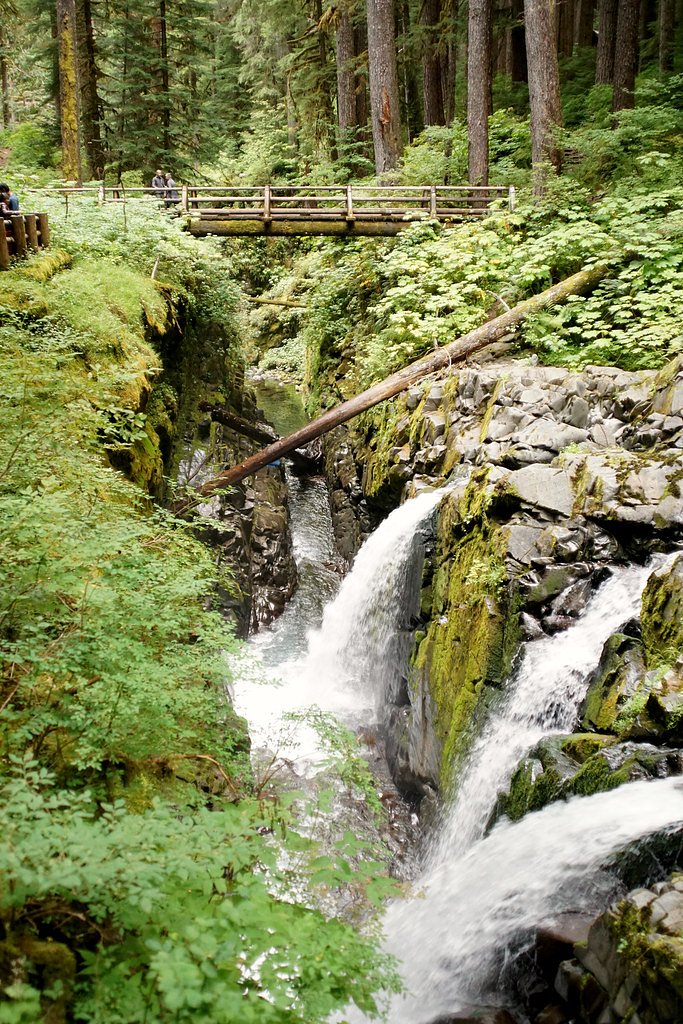
Salmon Falls
By Armen Suny · Last verified Mar 2026
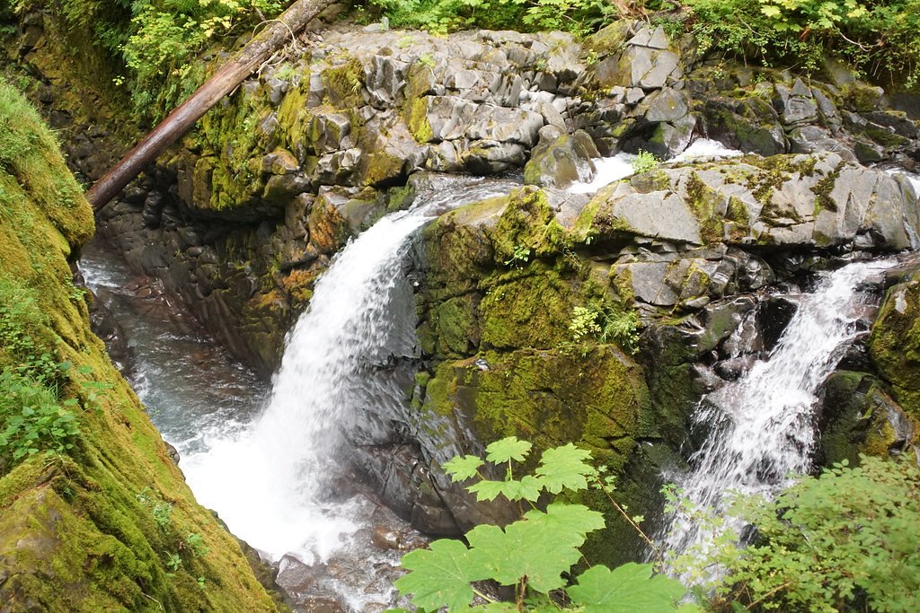
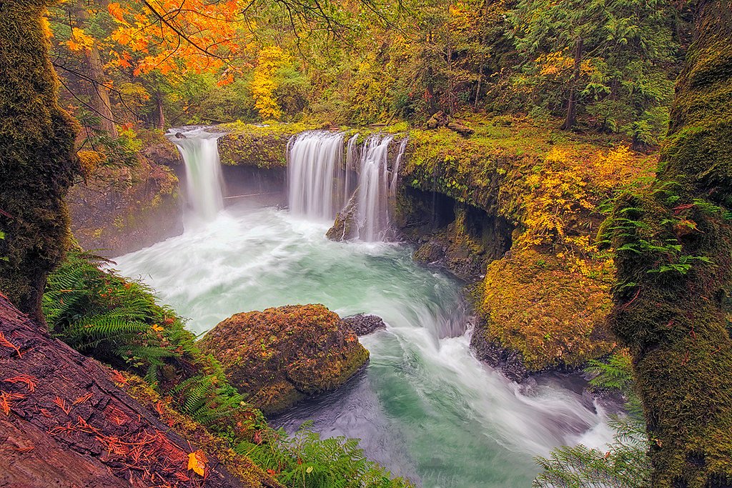
Photo Credits (5)
Difficulty
Moderate
Trail Length
2.4 miles
Trail Type
Out And Back
Elevation Gain
350 ft
About Salmon Falls
Salmon Falls is a quietly scenic cascade tucked into Washington's rugged forestlands, where water tumbles over a rocky ledge into a clear plunge pool — a favorite subject for photographers and a peaceful reward for a short hike. The falls sit on National Forest System land managed by the U.S. Forest Service within the Okanogan National Forest, and the most common access follows a segment of the USFS Boulder Creek Trail (Trail #SNO-04 37). The setting feels remote yet approachable, with a mix of shaded forest and open rock ledges that invite a relaxed stop to enjoy the view. Note that “Salmon Falls” is a common place name — Wikipedia lists several other locations with the same name across the U.S. — so be sure you’re headed to the Washington falls in Okanogan National Forest. Services are limited nearby; the Methow Valley Ranger District (the nearest developed ranger/camping support) is roughly 26.5 km from the trailhead, so plan accordingly and check with the Forest Service for seasonal access and trail updates before you go.
The Setting
Salmon Falls sits at 3,173 feet within Okanogan National Forest, fed by the West Fork Salmon Creek, in the mountains of Washington.
Trail & Hike Details
The Approach
The moderate hike follows Boulder Creek (#SNO-04 37), a 2.4-mile out-and-back trail over n/a. Expect 350 feet of elevation gain with grades of N/A.
USFS Trail
BOULDER CREEK #SNO-04 37
Trail Class
Class 0
Surface
Avg Grade
USFS Segment
32.97 miTrail Description
The trail to Salmon Falls is an out-and-back route of about 2.4 miles (round trip) with roughly 350 feet of elevation gain, rated moderate. Hikers typically use a section of the USFS Boulder Creek Trail (Trail #SNO-04 37) to reach the viewpoint. According to USFS data this route falls under Trail Class: N; surface and typical grade are listed as N/A in the database. (The Boulder Creek Trail system is mapped at 32.97 GIS miles in USFS records, though the commonly hiked segment to the falls is much shorter.) Expect natural tread and typical forest trail conditions; check the Okanogan National Forest / Methow Valley Ranger District for current trail conditions before heading out.
What to Expect
Visitors can expect a tranquil natural setting with the sound of cascading water and opportunities for photography. The area may have uneven terrain, so sturdy footwear is recommended.
Accessibility
The trail is not wheelchair accessible. Uneven terrain and elevation changes require steady footing.
Frequently Asked Questions
🐶 Are Dogs Allowed at Salmon Falls?
❌ Dogs are not allowed
Are There Any Fees or Permits Required?
🆖 No fees required
🏊 Is There Swimming at Salmon Falls?
❌ Swimming is not allowed
When to Visit
Spring and early summer are ideal times to visit, as the water flow is typically stronger due to snowmelt.
Seasonal Access
The best time to visit is Spring, Summer, and Fall. Winter access may be limited. Check with Okanogan National Forest for seasonal road closures.
Safety Information
Visitors should be cautious of slippery rocks, uneven terrain, and changing weather conditions. Always stay on marked trails and avoid getting too close to the edge of the falls.
Current Water Conditions
9 ft³/s
Current discharge — how much water is flowing
Much lower than usual for this time of year
Based on 13 years of record
5.93 ft
Water depth at gauge
7-Day Discharge Trend
What does this mean for your visit?
Flow is well below normal for this time of year, so the waterfall may be a trickle.
About This Gauge
7-Day Flow Outlook
Based on the USGS gauge WEST FORK SALMON CREEK NEAR CONCONULLY, WA (6 km away).
Today
Low
9 cfs
6/10Tomorrow
Low
10 cfs
4/10Sat
Moderate
10 cfs
5/10Sun
Low
9 cfs
6/10Mon
Low
9 cfs
4/10Tue
Moderate
9 cfs
5/10Wed
Moderate
8 cfs
5/10Best window: Today — low flow, partly sunny (trip score 6/10).
Best time of year: this gauge typically runs highest from late March to early July, peaking in May.
How we calculate this
This is a transparent outlook, not a precise forecast. We take the waterfall's current flow strength (how it ranks against its historical normal for today, from the nearest USGS stream gauge), carry that ranking forward along the gauge's seasonal curve, and nudge it for forecast rain. Confidence is highest for the next day or two and falls further out. Always check official conditions and your own judgment before visiting — high flows can be dangerous.
Know when to go.
Get a free email alert when waterfalls near Conconully hit peak flow. We only send when conditions are worth the trip — no weekly newsletters, no spam.
Weather Forecast
Location & Access
Getting There
Salmon Falls is located in the southwestern region of Washington. Access is typically via local roads, and visitors should check for specific directions based on their starting location.
Get Directions on Google MapsParking
Parking availability may vary depending on the season and local conditions. Visitors are advised to check for designated parking areas nearby.
Elevation
3,173 feet above sea level
Coordinates
48.554314° N, -119.847572° W
Land Management
Managed by USFS
Visitor Tips & Gear
Bring water, wear sturdy shoes, and check weather conditions before visiting. Cell service may be limited in the area.
As an Amazon Associate, we earn from qualifying purchases.
With 2.4 miles and 350 ft of elevation gain, sturdy boots and trekking poles will help on this moderate trail. Sun exposure on the trail makes good sun protection a must in summer.

Polarized Sunglasses (Knockaround)
Cuts glare off the water so you actually see the falls — and your photos turn out better too.

Columbia Watertight II Rain Jacket
Packs into its own pocket, seam-sealed, and keeps you dry from spray and surprise rain.

Earth Pak Waterproof Dry Bag
Keeps your phone and gear dry when waterfall mist soaks everything else.

Waterproof Phone Pouch (AiRunTech)
Cheap insurance — take photos right next to the falls without killing your phone.

Timberland Euro Sprint Mid Waterproof
Trusted waterproof boot with premium leather and grippy rubber sole — reliable on rocky, wet trails.

TrailBuddy Trekking Poles
Lightweight aluminum, cork grips, and flip-locks that actually hold — a best-seller for good reason.
Where to Stay

Omak Inn

Twisp River Suites

Best Western PLUS Peppertree Inn at Omak

AbbyCreek Inn
Browse vacation cabins and private rentals nearby
Unique outdoor stays — tents, yurts, and treehouses
Rent a campervan or RV for your waterfall road trip
Some links are affiliate links. We may earn a commission at no extra cost to you.
Nearby Campground
Methow Valley Ranger District
16.5 miles away · 0 sites
With its big valleys, open wildspaces, high ridges and beautiful rivers, the Methow Valley Ranger District's 1.3 million acres extends from near the town of Twisp Washington to the crest of the Cascade Mountains in the Pasayten Wilderness. Alpine lakes are a hideaway for anglers while diverse wilderness awaits explorers of all types. There are bassalt formations for rock climbers and winter sports opportunities abound. The highest peak is Jack Mountain at 9,066 feet, with many other peaks above
Book on Recreation.govNearby Hot Springs
Hot springs near Conconully, Washington
Poison Lake
Poison Lake reaches 122 degrees Fahrenheit in north-central Washington's Okanogan County, creating a thermal difference of 70.7...
Hot Lake
Hot Lake reaches 122 degrees at 1,902 feet elevation on Bureau of Land Management property in Okanogan County, producing water ...
Looking for a soak after your hike? Explore more hot springs near Conconully, Washington on SoakingSprings.
Explore Washington springsAdditional Information
Nearby Attractions
Nearby attractions may include other waterfalls, hiking trails, and scenic viewpoints in the region.
Wildlife
The area around Salmon Falls may be home to various wildlife, including birds, deer, and small mammals. Visitors should respect wildlife and maintain a safe distance.
Cities near Salmon Falls
Other waterfalls named Salmon Falls
6 other waterfalls share this name across the U.S.
Writing about Salmon Falls? Embed this waterfall on your site for free.