Photo Credits (2)
Difficulty
Moderate
Trail Length
0.5 km
Trail Type
Out And Back
Elevation Gain
15 m
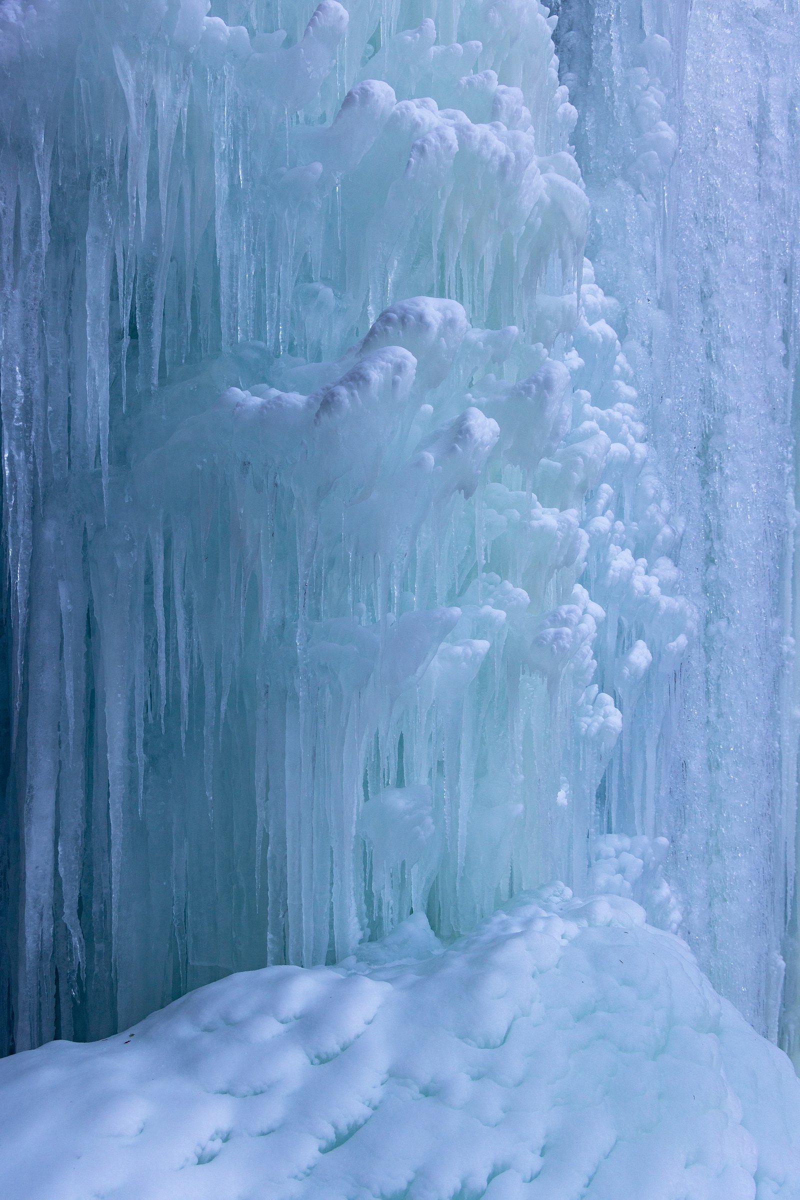
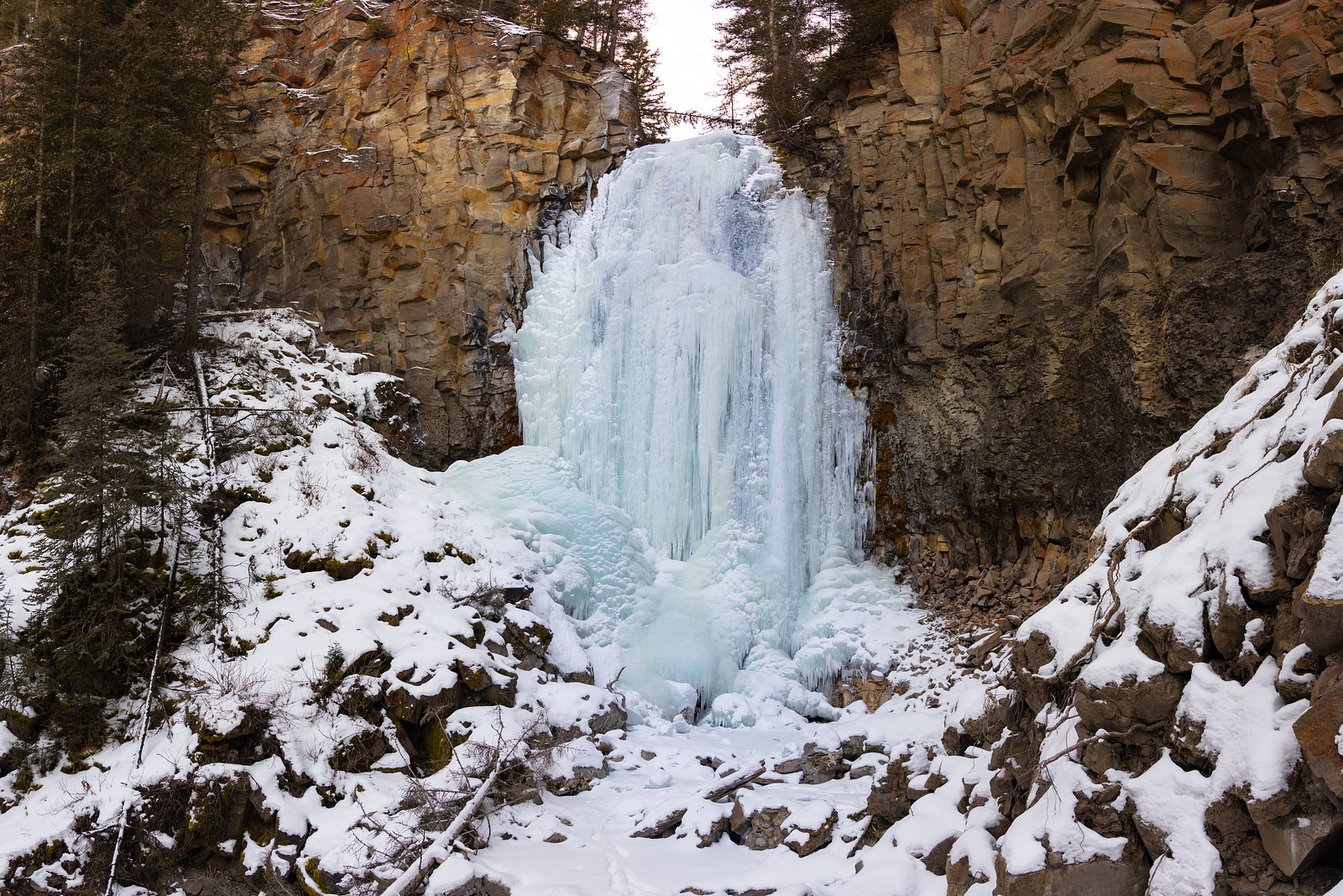
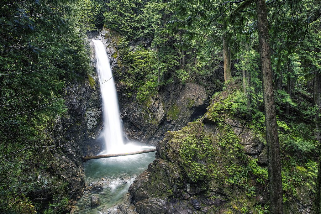
About Lost Creek Falls
Lost Creek Falls is a small, wooded cascade on Lost Creek in the Fraser Valley of British Columbia, located near Abbotsford, Sumas and Chilliwack (coordinates 49.3283, -122.2625). The feature is lightly documented and appears to be a modest, seasonal waterfall set in mixed second‑growth forest and riparian corridor. Access is informal in places and may require short bushwhacking or travel on unmaintained or forestry roads; some descriptions from local visitors suggest a short walk from a roadside pullout but exact route details are not well established. Expect a natural, undeveloped setting rather than a formal viewpoint or maintained park infrastructure.
The Setting
Lost Creek Falls sits at 194 metres in the foothills of British Columbia. The falls drop 10 metres.
Why This Waterfall Exists
Lost Creek Falls flows over hard intrusive rock laid down about 145-162 million years ago. These resistant rocks form a durable ledge that water cannot easily wear away, creating a 32-foot drop where softer material downstream has already eroded.
Nearby Falls Worth Visiting
Thunder Falls (100 m) lies 5.0 kilometres to the north. Also nearby: Cascade Falls (30 m, 6.9 km) and McDonald Falls (25 m, 4.0 km).
Trail & Hike Details
The Approach
The moderate 0.5-km out-and-back trail gains 15 metres of elevation on the way to the falls.
Trail Description
There is no widely published, maintained trail description for Lost Creek Falls. Visitor reports suggest a short, informal approach from a nearby road or forestry track with uneven, possibly steep and muddy terrain near the creek. Expect narrow boot paths, downed wood, and potentially a short bushwhack to reach views of the cascade. The viewing area may be limited and require careful footing on roots and wet rocks.
What to Expect
The falls drop 10 metres over hard intrusive rock.
Accessibility
The trail is not wheelchair accessible. Uneven terrain and elevation changes require steady footing.
Frequently Asked Questions
🐶 Are Dogs Allowed at Lost Creek Falls?
❌ Dogs are not allowed
Are There Any Fees or Permits Required?
🆖 No fees required
🏊 Is There Swimming at Lost Creek Falls?
❌ Swimming is not allowed
When to Visit
Spring and early fall for higher flows and better waterfall appearance; mornings offer softer light for photography. Late summer may have reduced flow. Avoid heavy rainstorms where creek levels and current can become hazardous.
Seasonal Access
The best time to visit is Spring, Summer, Fall, and Winter. Check with the managing park or local authority for current conditions.
Safety Information
Hazards include slippery banks, unstable or loose rock near the creek, seasonal high flows and strong currents after heavy rain, thorny brush, and ticks. Access may require crossing private land, trespass can be illegal and dangerous. Use caution near edges, avoid climbing on wet rocks, and supervise children closely. If conditions are unclear, choose a safer alternative or consult local authorities/community trip reports before visiting.
7-Day Flow Outlook
Based on the WSC gauge FRASER RIVER AT MISSION (23 km away).
Best time of year: this gauge typically runs highest from early May to early August, peaking in June.
How we calculate this
This is a transparent outlook, not a precise forecast. We take the waterfall's current flow strength (how it ranks against its historical normal for today, from the nearest WSC stream gauge), carry that ranking forward along the gauge's seasonal curve, and nudge it for forecast rain. Confidence is highest for the next day or two and falls further out. Always check official conditions and your own judgment before visiting — high flows can be dangerous.
Know when to go.
Get a free email alert when waterfalls near Abbotsford hit peak flow. We only send when conditions are worth the trip — no weekly newsletters, no spam.
Weather Forecast
Location & Access
Getting There
The falls lie in the Fraser Valley region near Abbotsford (approx. 15 miles), Sumas (approx. 16.6 miles) and Chilliwack (approx. 21 miles) by road. Nearest access is typically via local rural/forest roads, GPS coordinates are the most reliable guide. Approaches reported by visitors are informal and may involve walking from a roadside pullout or following an unmarked/unmaintained track. Some routes may cross private property or active forestry land; confirm access and respect private property signage.
Get Directions on Google MapsParking
No formal parking lot is known. Parking is likely limited to a roadside pullout or shoulder parking where permitted. Do not block gates, driveways, or farm access; parking enforcement or private requests to move vehicles may occur.
Elevation
194 metres above sea level
Coordinates
49.328328° N, -122.262457° W
Visitor Tips & Gear
• Use the provided coordinates and an up‑to‑date GPS or mapping app; terrain and logging roads can change. • Wear sturdy, waterproof footwear with good traction; expect mud and slippery rocks. • Be prepared to bushwhack short sections; bring a walking stick for stability. • Respect private property, do not cross fences or enter posted land without permission. • Inform someone of your route and expected return time on informal trails. • Leave no trace: pack out all waste and avoid disturbing riparian vegetation. • Check recent trip reports or local forums (AllTrails, regional hiking groups) for current access notes.
As an Amazon Associate, we earn from qualifying purchases.
With 0.5 km and 15 m of elevation gain, sturdy boots and trekking poles will help on this moderate trail. Icy conditions are common in winter — traction cleats are a smart addition.

Columbia Watertight II Rain Jacket
Packs into its own pocket, seam-sealed, and keeps you dry from spray and surprise rain.

Polarized Sunglasses (Knockaround)
Cuts glare off the water so you actually see the falls — and your photos turn out better too.

Earth Pak Waterproof Dry Bag
Keeps your phone and gear dry when waterfall mist soaks everything else.

Waterproof Phone Pouch (AiRunTech)
Cheap insurance — take photos right next to the falls without killing your phone.

Timberland Euro Sprint Mid Waterproof
Trusted waterproof boot with premium leather and grippy rubber sole — reliable on rocky, wet trails.

TrailBuddy Trekking Poles
Lightweight aluminum, cork grips, and flip-locks that actually hold — a best-seller for good reason.
Where to Stay
Browse vacation cabins and private rentals nearby
Unique outdoor stays — tents, yurts, and treehouses
Rent a campervan or RV for your waterfall road trip
Some links are affiliate links. We may earn a commission at no extra cost to you.
Nearby Campground
Stave Island Dispersed Site
4.2 km away
Nearby Hot Springs
Hot springs near Abbotsford, British Columbia
Dorr Fumarole Field
Dorr Fumarole Field reaches 194 degrees at 8,168 feet elevation on Mount Baker's active volcanic slopes, producing superheated ...

Sherman Crater Fumaroles
Sherman Crater Fumaroles register 266 degrees Fahrenheit at 9,463 feet elevation within the active volcanic crater atop Mount B...
Baker Hot Spring
Baker Hot Spring emerges at 108 degrees Fahrenheit on US Forest Service land in Mt. Baker National Forest, flowing 59.5 degrees...
Looking for a soak after your hike? Explore more hot springs near Abbotsford, British Columbia on SoakingSprings.
Explore British Columbia springsAdditional Information
Nearby Attractions
Minter Gardens (Abbotsford), Sumas Mountain trails, Bridal Veil Falls (near Chilliwack), Cultus Lake Provincial Park, these regional attractions are popular but may be some distance away; plan accordingly.
Wildlife
Typical Fraser Valley wildlife may include deer, coyotes, raptors and songbirds, and potentially black bears or cougars in more remote areas. Ticks and mosquitoes are common in riparian forest. Be bear aware and store food responsibly.
Cities near Lost Creek Falls
Nearby Waterfalls
Other waterfalls named Lost Creek Falls
4 other waterfalls share this name across Canada.
Writing about Lost Creek Falls? Embed this waterfall on your site for free.