Photo Credits (2)
Difficulty
Moderate
Trail Length
2.5 miles
Trail Type
Out And Back
Elevation Gain
300 ft
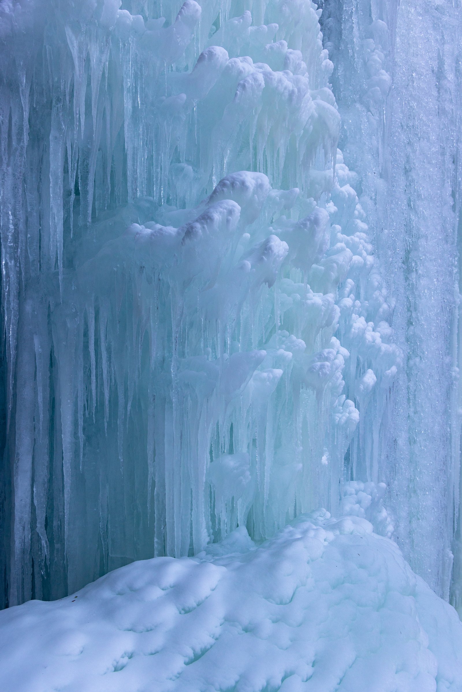
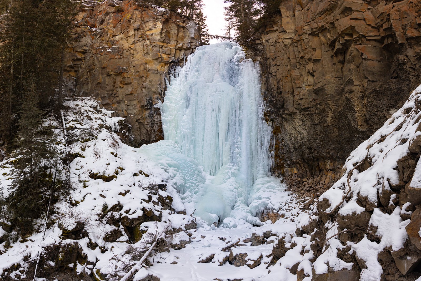
About Lost Creek Falls
Lost Creek Falls is a quietly scenic waterfall tucked into the forested slopes of Payette National Forest, managed by the U.S. Forest Service. The falls offer a peaceful setting for hikers and nature photographers, with a short but rewarding approach through dense mixed-conifer woods. The route to the falls is an out-and-back trek of about 2.5 miles round trip with roughly 300 feet of elevation gain, making it a reachable half-day outing for most moderately fit hikers. Camping is nearby: Cold Springs Campground (Payette NF) sits roughly 3.6 km from the trailhead, so you can easily combine an overnight stay with an early-morning or late-afternoon visit to avoid crowds. Before you go, check current conditions and any seasonal advisories with the U.S. Forest Service for Payette National Forest to ensure the best experience on the trail and at the falls.
The Setting
Lost Creek Falls sits at 4,386 feet within Payette National Forest, fed by the Nf Payette River, in the mountains of Idaho.
Trail & Hike Details
The Approach
The moderate 2.5-mile out-and-back trail gains 300 feet of elevation on the way to the falls.
Trail Description
The trail to Lost Creek Falls is a moderately rated out-and-back route of about 2.5 miles round trip with approximately 300 feet of cumulative elevation gain. The tread passes through forested terrain with a mix of flat stretches and gentle inclines; hikers will encounter some rocky or uneven sections. The route is generally well-marked and maintained by the U.S. Forest Service within Payette National Forest, but portions can become muddy or slippery after rain, so sturdy footwear and basic traction care are recommended.
What to Expect
Dogs are welcome.
Accessibility
The trail is not wheelchair accessible. Uneven terrain and elevation changes require steady footing.
Frequently Asked Questions
🐶 Are Dogs Allowed at Lost Creek Falls?
✅ Dogs are allowed
Are There Any Fees or Permits Required?
🆖 No fees required
🏊 Is There Swimming at Lost Creek Falls?
❌ Swimming is not allowed
When to Visit
Spring and early summer are ideal for visiting Lost Creek Falls, as the waterfall is typically at its fullest due to snowmelt. Fall offers beautiful foliage, while summer provides warmer weather for hiking.
Seasonal Access
The best time to visit is Spring, Summer, and Fall. Winter access may be limited. Check with Payette National Forest for seasonal road closures.
Safety Information
Be cautious of slippery rocks near the waterfall. Check weather conditions before visiting, as rain can make the trail muddy and more challenging. Carry a map or GPS device, as cell service may be limited.
Current Water Conditions
Based on a USGS gauge 16.4 miles away
474 ft³/s
Current discharge — how much water is flowing
About average for this time of year
Based on 116 years of record
3.44 ft
Water depth at gauge
7-Day Discharge Trend
What does this mean for your visit?
Flow is about average for this time of year.
About This Gauge
This gauge is on a regional waterway. Conditions at the falls may differ, especially after local rain.
7-Day Flow Outlook
Based on the USGS gauge NF PAYETTE RIVER AT MCCALL ID (26 km away).
Today
Roaring
512 cfs
6/10Tomorrow
Roaring
411 cfs
6/10Tue
Roaring
339 cfs
9/10Wed
Roaring
308 cfs
9/10Thu
Roaring
297 cfs
9/10Fri
Roaring
317 cfs
6/10Sat
Roaring
287 cfs
9/10Best window: Tue — roaring flow, mostly sunny (trip score 9/10).
Best time of year: this gauge typically runs highest from mid April to mid July, peaking in May.
How we calculate this
This is a transparent outlook, not a precise forecast. We take the waterfall's current flow strength (how it ranks against its historical normal for today, from the nearest USGS stream gauge), carry that ranking forward along the gauge's seasonal curve, and nudge it for forecast rain. Confidence is highest for the next day or two and falls further out. Always check official conditions and your own judgment before visiting — high flows can be dangerous.
Know when to go.
Get a free email alert when waterfalls near New Meadows hit peak flow. We only send when conditions are worth the trip — no weekly newsletters, no spam.
Weather Forecast
Location & Access
Getting There
Lost Creek Falls is located within the Clearwater National Forest in Idaho. Access typically involves driving on forest service roads, which may be unpaved and require a high-clearance vehicle depending on conditions. Directions should be confirmed with local ranger stations or reliable trail resources.
Get Directions on Google MapsParking
Parking is available near the trailhead, but spaces may be limited. Visitors should plan to arrive early, especially during peak seasons.
Elevation
4,386 feet above sea level
Coordinates
44.917778° N, -116.453056° W
Land Management
Managed by USFS
Visitor Tips & Gear
Wear sturdy hiking shoes, as the trail can be uneven or slippery. Bring insect repellent during warmer months, as mosquitoes may be present. Arrive early to secure parking and enjoy the trail with fewer crowds.
As an Amazon Associate, we earn from qualifying purchases.
With 2.5 miles and 300 ft of elevation gain, sturdy boots and trekking poles will help on this moderate trail. Sun exposure on the trail makes good sun protection a must in summer.

Polarized Sunglasses (Knockaround)
Cuts glare off the water so you actually see the falls — and your photos turn out better too.

Columbia Watertight II Rain Jacket
Packs into its own pocket, seam-sealed, and keeps you dry from spray and surprise rain.

Earth Pak Waterproof Dry Bag
Keeps your phone and gear dry when waterfall mist soaks everything else.

Waterproof Phone Pouch (AiRunTech)
Cheap insurance — take photos right next to the falls without killing your phone.

Timberland Euro Sprint Mid Waterproof
Trusted waterproof boot with premium leather and grippy rubber sole — reliable on rocky, wet trails.

TrailBuddy Trekking Poles
Lightweight aluminum, cork grips, and flip-locks that actually hold — a best-seller for good reason.
Where to Stay

Cozy Cabin in McCall

Ponderosa

Sierra Miracle

Papas House on the Golf Course
Browse vacation cabins and private rentals nearby
Unique outdoor stays — tents, yurts, and treehouses
Rent a campervan or RV for your waterfall road trip
Some links are affiliate links. We may earn a commission at no extra cost to you.
Nearby Campground
Cold Springs Campground - Payette NF (ID)
2.2 miles away · 34 sites
Overview Cold Springs Campground is located near Lost Valley Reservoir, just 10 miles from New Meadows, Idaho. Visitors enjoy boating, fishing and swimming. Once on-site, you may be able to pay for your campsite(s) by scanning a QR code using the Recreation.gov mobile app, and the Scan and Pay feature. If this option is available, you will need to first download the free Recreation.gov mobile app https://www.recreation.gov/mobile-app prior to your arrival as some remote areas have limited or no c
Book on Recreation.govNearby Hot Springs
Hot springs near New Meadows, Idaho
Starkey Hot Springs
Starkey Hot Springs delivers 131-degree water at just 3,290 feet elevation in Adams County, one of the lower-elevation thermal ...
Zims Resort Hot Springs
Zims Resort Hot Springs delivers 144°F water virtually at roadside, sitting just 17 feet from Zims Road in Valley County, Idaho...
Krigbaum Hot Springs
Krigbaum Hot Springs emerges at 109 degrees Fahrenheit along the Goose Creek drainage in the Payette National Forest, offering ...
Stinky Warm Spring
Stinky Warm Spring earns its name from hydrogen sulfide gas that gives the 88-degree water a distinct rotten-egg smell, a commo...
Council Mtn Hot Springs
Council Mountain Hot Springs surfaces at 154 degrees Fahrenheit in Payette National Forest, running a full 109 degrees above th...

Boulder Creek Spring
Boulder Creek Spring delivers 82-degree Fahrenheit water just 52 feet from Boulder Creek Road near McCall, with an exceptionall...
Looking for a soak after your hike? Explore more hot springs near New Meadows, Idaho on SoakingSprings.
Explore Idaho springsAdditional Information
Nearby Attractions
Other attractions in the Clearwater National Forest include the Lochsa River and the Selway-Bitterroot Wilderness.
Wildlife
The area is home to a variety of wildlife, including deer, birds, and small mammals. Visitors should be cautious of bears and carry bear spray if hiking in remote areas.
Cities near Lost Creek Falls
Other waterfalls named Lost Creek Falls
4 other waterfalls share this name across the U.S.
Writing about Lost Creek Falls? Embed this waterfall on your site for free.