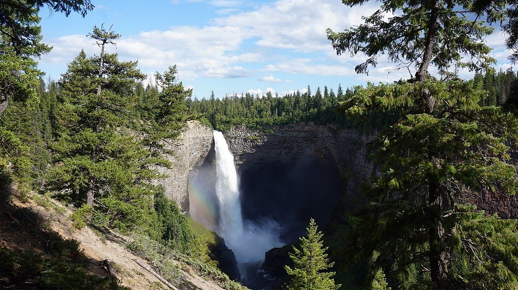
Thunder Falls
British Columbia • 100 m
By Armen Suny · Last verified Jun 2026
Photo Credits (1)
About Thunder Falls
Thunder Falls is a forested creek-side waterfall located in the Fraser Valley region of British Columbia (coords: 49.3724, -122.2515), roughly 18–23 miles east of Abbotsford, Sumas and Chilliwack. Reports indicate it is a natural, multi-step cascade set in mixed coniferous forest. Specific published information about the falls (official height, volume, and an established maintained trail) is limited; the following description draws on typical conditions for creeks and small waterfalls in this area and on recent visitor-style reports.
The Setting
Thunder Falls sits at 315 metres in the foothills of British Columbia. At 100 metres, it is among the taller waterfalls in British Columbia.
Why This Waterfall Exists
Thunder Falls flows over hard intrusive rock laid down about 145-162 million years ago. These resistant rocks form a durable ledge that water cannot easily wear away, creating a 328-foot drop where softer material downstream has already eroded.
Nearby Falls Worth Visiting
McDonald Falls (25 m) lies 8.5 kilometres to the south. Also nearby: Terepocki Twin Falls (13 m, 2.1 km) and Lost Creek Falls (10 m, 5.0 km).
Trail & Hike Details
Trail Description
There is no widely published, maintained trail guide for Thunder Falls at the provided coordinates. Visitor accounts for similarly situated falls in the Fraser Valley describe short but sometimes indistinct trails that descend through forest, often crossing damp, mossy sections and uneven rocky ground. Expect a mix of singletrack, informal footpaths, and short scrambles near the creek. Because the trail may be unmaintained, routefinding skills can be required and conditions can change after storms or logging activity.
What to Expect
The falls plunge a dramatic 100 metres over hard intrusive rock.
Accessibility
Likely not wheelchair accessible. Approaches are expected to be on natural, uneven ground and may include short scrambles and slippery surfaces.
Frequently Asked Questions
🐶 Are Dogs Allowed at Thunder Falls?
❌ Dogs are not allowed
Are There Any Fees or Permits Required?
🆖 No fees required
🏊 Is There Swimming at Thunder Falls?
❌ Swimming is not allowed
When to Visit
Spring (late March–May) for highest water flows and dramatic cascades. Summer provides easier hiking and more stable access but lower flows; early morning or weekdays reduce parking pressure. Fall can be colorful and less crowded; avoid winter storms/ice when approaches can be hazardous.
Seasonal Access
The best time to visit is Spring, Summer, and Fall. Winter access may be limited. Check with the managing park or local authority for current conditions.
Safety Information
Hazards include slippery rocks, steep and unmarked approaches, variable stream flows (dangerous after heavy rain or spring melt), and potentially unstable banks. There may be no formal barriers at lookout points, keep distance from the edge. Avoid entering fast-moving water. Check recent trip reports and local advisories before visiting. If unsure of land status, do not trespass; some access may cross private property or active logging areas.
Current Water Conditions
24.2 m³/s
Current discharge — how much water is flowing
Much lower than usual for this time of year
Based on 42 years of record
2.49 m
Water depth at gauge
7-Day Discharge Trend
What does this mean for your visit?
Flow is well below normal for this time of year, so the waterfall may be a trickle.
About This Gauge
This gauge is on a nearby waterway and may not reflect exact conditions at the falls.
7-Day Flow Outlook
Based on the WSC gauge STAVE RIVER ABOVE STAVE LAKE (21 km away).
Today
Barely Flowing
25 m³/s
4/10Tomorrow
Barely Flowing
23 m³/s
4/10Tue
Barely Flowing
25 m³/s
4/10Wed
Barely Flowing
25 m³/s
4/10Thu
Barely Flowing
27 m³/s
3/10Fri
Barely Flowing
24 m³/s
4/10Sat
Barely Flowing
24 m³/s
3/10Best window: Today — barely flowing flow, cloudy (trip score 4/10).
Best time of year: this gauge typically runs highest from early May to late July, peaking in June.
How we calculate this
This is a transparent outlook, not a precise forecast. We take the waterfall's current flow strength (how it ranks against its historical normal for today, from the nearest WSC stream gauge), carry that ranking forward along the gauge's seasonal curve, and nudge it for forecast rain. Confidence is highest for the next day or two and falls further out. Always check official conditions and your own judgment before visiting — high flows can be dangerous.
Know when to go.
Get a free email alert when waterfalls near Abbotsford hit peak flow. We only send when conditions are worth the trip — no weekly newsletters, no spam.
Weather Forecast
Location & Access
Getting There
General approach is from local secondary roads/forest roads off the Highway 1 / local east Fraser Valley network; nearest population centers are Abbotsford (≈17.8 miles), Sumas (≈19.2 miles) and Chilliwack (≈22.8 miles). Use the coordinates (49.3724, -122.2515) in a mapping app to identify the closest public road or trailhead. Access routes may include short unpaved roads and spur trails. Exact public access points are not well-documented, check recent trip reports or local land status before visiting and avoid crossing private property.
Get Directions on Google MapsParking
Parking is likely limited to a small pullout or roadside parking near the trailhead or access road. There may not be an official parking lot, and parking on narrow shoulders can be unsafe. If parking is on a public road, follow posted signs and avoid blocking gates or driveways. If access is via forest service roads, park only in designated areas.
Elevation
315 metres above sea level
Coordinates
49.372412° N, -122.251534° W
Visitor Tips & Gear
• Use the provided coordinates in a map app and check recent trip reports (AllTrails, local hiking forums) for the latest access notes. • Wear waterproof, grippy footwear, stream and rock surfaces will be slippery. • Stay off wet rocks near the lip; wet rock and moss are a common hazard. • Respect private property and posted signs, do not cut fences or cross fields. • If planning to visit in spring or after heavy rain, expect high flows and stronger currents. • Bring a map, compass or GPS and tell someone your plan. Cell service can be spotty. • Park legally and avoid blocking gates or narrow shoulders.
Where to Stay
Browse vacation cabins and private rentals nearby
Unique outdoor stays — tents, yurts, and treehouses
Rent a campervan or RV for your waterfall road trip
Some links are affiliate links. We may earn a commission at no extra cost to you.
Nearby Campground
Cypress Point
1.5 km away
Nearby Hot Springs
Hot springs near Abbotsford, British Columbia
Dorr Fumarole Field
Dorr Fumarole Field reaches 194 degrees at 8,168 feet elevation on Mount Baker's active volcanic slopes, producing superheated ...

Sherman Crater Fumaroles
Sherman Crater Fumaroles register 266 degrees Fahrenheit at 9,463 feet elevation within the active volcanic crater atop Mount B...
Baker Hot Spring
Baker Hot Spring emerges at 108 degrees Fahrenheit on US Forest Service land in Mt. Baker National Forest, flowing 59.5 degrees...
Looking for a soak after your hike? Explore more hot springs near Abbotsford, British Columbia on SoakingSprings.
Explore British Columbia springsAdditional Information
Nearby Attractions
Nearby attractions in the Fraser Valley region include Cultus Lake Provincial Park, Chilliwack Lake Provincial Park, the Vedder River / Rotary Trail and local viewpoints in the Fraser Valley. Exact distances vary depending on route.
Wildlife
Typical low-elevation coastal BC wildlife: black bear, deer, small mammals, and a variety of birds. Be aware of ticks in warmer months and take standard wildlife-safety precautions.
Cities near Thunder Falls
Nearby Waterfalls
Other waterfalls named Thunder Falls
2 other waterfalls share this name across Canada.
Writing about Thunder Falls? Embed this waterfall on your site for free.