
Lost Creek Falls
By Armen Suny · Last verified May 2026
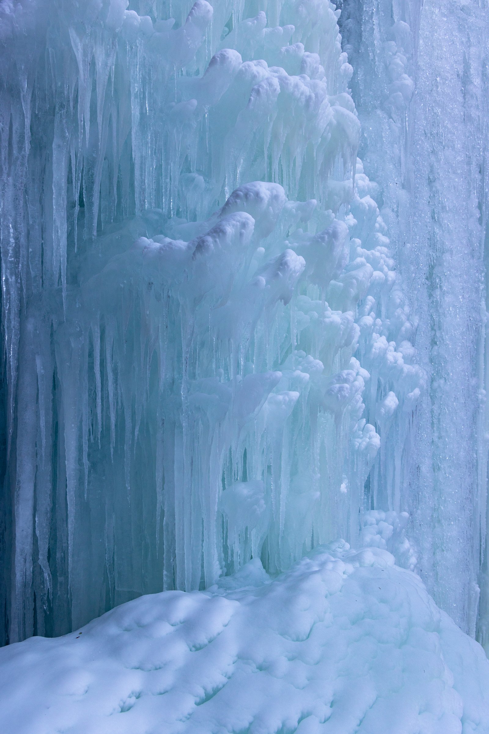
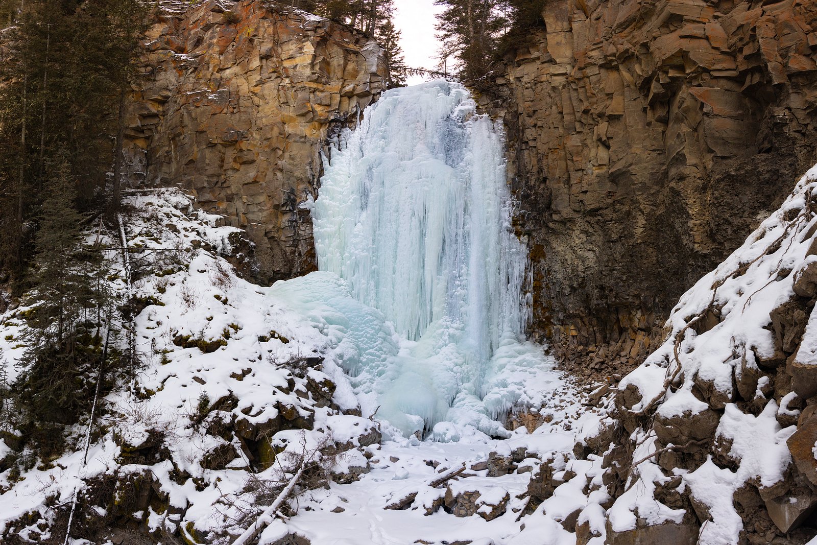
Photo Credits (3)
Difficulty
Moderate
Trail Length
2.4 miles
Trail Type
Out And Back
Elevation Gain
350 ft
About Lost Creek Falls
Lost Creek Falls is a picturesque cascade tucked into the forested hills of western Montana, nestled within the Lolo National Forest and managed by the U.S. Forest Service. The falls spill over rocky ledges into a peaceful pool, surrounded by mixed conifer and understory that makes it an inviting destination for a half-day outing. Hikers on the route are rewarded with a serene, photogenic setting that feels a world away from busy trailheads. Access to the falls follows the USFS LOST LAKE Trail (Trail #112). While the most commonly described route to reach the waterfall is a moderate 2.4-mile out-and-back with about 350 feet of elevation gain, official USFS GIS data lists LOST LAKE Trail #112 at approximately 3.97 miles. Either way, the trail is a classic Lolo National Forest hike—wooded, steadily graded, and managed by the Forest Service—so come prepared for a moderate effort and enjoy a relatively quiet slice of Montana forest scenery.
The Setting
Lost Creek Falls sits at 5,046 feet within Lolo National Forest, fed by the St. Regis River, in the high mountains of Montana.
Trail & Hike Details
The Approach
The moderate hike follows Lost Lake (#112), a 2.4-mile out-and-back trail over natural surface. Expect 350 feet of elevation gain with grades of 12-20%. The trail is developed (Class 3).
USFS Trail
LOST LAKE #112
Trail Class
Developed
Surface
Avg Grade
USFS Segment
3.97 miTrail Description
Trail: LOST LAKE (USFS Trail #112). Type: out-and-back. Commonly hiked distance to the falls: ~2.4 miles round-trip with ~350 ft elevation gain; USFS GIS listing: 3.97 miles. Difficulty: moderate. Surface: native material. USFS class: 3. Typical grade: 12–20%. Expect a natural tread through forest with steady uphill sections; good footwear is recommended for traction on native-surface tread and rocky approaches near the falls.
What to Expect
Dogs are welcome.
Accessibility
The trail is not wheelchair accessible. Uneven terrain and elevation changes require steady footing.
Frequently Asked Questions
🐶 Are Dogs Allowed at Lost Creek Falls?
✅ Dogs are allowed
Are There Any Fees or Permits Required?
🤑 Fee: $7.00
🏊 Is There Swimming at Lost Creek Falls?
❌ Swimming is not allowed
When to Visit
Spring and early summer are the best times to visit, as the waterfall is most active during these seasons due to snowmelt.
Seasonal Access
The best time to visit is Spring, Summer, and Fall. Access roads and trails may close during winter due to snow. Check with Lolo National Forest for seasonal road closures.
Safety Information
Be cautious of slippery rocks near the waterfall, especially after rain. Watch for wildlife and stay on designated trails to avoid damaging the environment.
Current Water Conditions
251 ft³/s
Current discharge — how much water is flowing
Much lower than usual for this time of year
Based on 47 years of record
2.31 ft
Water depth at gauge
7-Day Discharge Trend
What does this mean for your visit?
Flow is well below normal for this time of year, so the waterfall may be a trickle.
About This Gauge
This gauge is on a nearby waterway and may not reflect exact conditions at the falls.
7-Day Flow Outlook
Based on the USGS gauge St. Regis River near St. Regis, MT (20 km away).
Today
Moderate
271 cfs
5/10Tomorrow
Moderate
263 cfs
5/10Mon
Moderate
250 cfs
5/10Tue
Moderate
245 cfs
5/10Wed
Moderate
204 cfs
8/10Thu
Moderate
182 cfs
8/10Fri
Moderate
191 cfs
5/10Best window: Wed — moderate flow, mostly sunny (trip score 8/10).
Best time of year: this gauge typically runs highest from late March to late June, peaking in May.
How we calculate this
This is a transparent outlook, not a precise forecast. We take the waterfall's current flow strength (how it ranks against its historical normal for today, from the nearest USGS stream gauge), carry that ranking forward along the gauge's seasonal curve, and nudge it for forecast rain. Confidence is highest for the next day or two and falls further out. Always check official conditions and your own judgment before visiting — high flows can be dangerous.
Know when to go.
Get a free email alert when waterfalls near St. Regis hit peak flow. We only send when conditions are worth the trip — no weekly newsletters, no spam.
Weather Forecast
Location & Access
Getting There
Lost Creek Falls is located within Lost Creek State Park, near Anaconda, Montana. The falls can be accessed via Lost Creek Road, which is a well-maintained gravel road leading to the park.
Get Directions on Google MapsParking
There is a designated parking area near the trailhead within Lost Creek State Park.
Elevation
5,046 feet above sea level
Coordinates
47.114930° N, -115.117412° W
Land Management
Managed by USFS
Visitor Tips & Gear
Wear sturdy shoes as the trail may be muddy in spring or after rain. Bring water and a camera to capture the scenic views. Arrive early during peak seasons to secure parking.
As an Amazon Associate, we earn from qualifying purchases.
With 2.4 miles and 350 ft of elevation gain, sturdy boots and trekking poles will help on this moderate trail. Sun exposure on the trail makes good sun protection a must in summer.

Polarized Sunglasses (Knockaround)
Cuts glare off the water so you actually see the falls — and your photos turn out better too.

Columbia Watertight II Rain Jacket
Packs into its own pocket, seam-sealed, and keeps you dry from spray and surprise rain.

Earth Pak Waterproof Dry Bag
Keeps your phone and gear dry when waterfall mist soaks everything else.

Waterproof Phone Pouch (AiRunTech)
Cheap insurance — take photos right next to the falls without killing your phone.

Timberland Euro Sprint Mid Waterproof
Trusted waterproof boot with premium leather and grippy rubber sole — reliable on rocky, wet trails.

TrailBuddy Trekking Poles
Lightweight aluminum, cork grips, and flip-locks that actually hold — a best-seller for good reason.
Where to Stay

Big Sky Motel

Peaceful Superior Home w/ Fire Pit & Mtn View

The Lodge at Forest Grove

Rustic Cabin Rental in the Tranquil Montana Wilderness near Missoula
Browse vacation cabins and private rentals nearby
Unique outdoor stays — tents, yurts, and treehouses
Rent a campervan or RV for your waterfall road trip
Some links are affiliate links. We may earn a commission at no extra cost to you.
Nearby Campground
THOMPSON PEAK LOOKOUT TOWER
10.8 miles away · 1 sites
Overview Thompson Peak Lookout provides great views of the Clark Fork Valley, the town of Superior, the Idaho state line and, of course, the big sky of Montana. It is close enough to Superior to allow for easy access, but remote enough to provide the quiet and solitude expected at a lookout. The modernized tower provides amenities not typical to a lookout, making it a desirable place to stay.Recreation A variety of trails exist in the area, allowing visitors a chance to explore the surrounding fo
Book on Recreation.govNearby Hot Springs
Hot springs near St. Regis, Montana
Quinns Hot Springs
Quinns Hot Springs flows at 109 degrees Fahrenheit in the Clark Fork River valley of Sanders County, Montana, at a low elevatio...
Weir Creek Hot Springs
Weir Creek Hot Springs surfaces at 117°F with strongly alkaline water (pH 9.4) in Idaho's Clearwater National Forest. Located a...
Green Springs
Green Springs flows at 79°F on the Flathead Reservation in Sanders County, Montana, at 2,813 feet — one of the lower-elevation ...

Colgate Warm Springs
Colgate Warm Springs registers pH 9.5, placing it among the most alkaline thermal features in Idaho. The water emerges at 106 d...

Jerry Johnson Hot Springs
Jerry Johnson Hot Springs is one of Idaho's most visited backcountry soaks, flowing at 118 degrees Fahrenheit along the Lochsa ...
Camas Hot Springs
Camas Hot Springs flows at 113°F on the Flathead Reservation in western Montana, managed as tribal land with restricted or unkn...
Looking for a soak after your hike? Explore more hot springs near St. Regis, Montana on SoakingSprings.
Explore Montana springsAdditional Information
Nearby Attractions
Lost Creek State Park offers additional hiking trails, picnic areas, and opportunities to view wildlife. The nearby town of Anaconda has historical sites and local dining options.
Wildlife
The area is home to deer, birds, and other small wildlife. Visitors may also spot mountain goats on the cliffs surrounding the park.
Cities near Lost Creek Falls
Nearby Waterfalls
Other waterfalls named Lost Creek Falls
4 other waterfalls share this name across the U.S.
Writing about Lost Creek Falls? Embed this waterfall on your site for free.