
Photo Credits (5)
Difficulty
Moderate
Trail Length
2.4 miles
Trail Type
Out And Back
Elevation Gain
350 ft
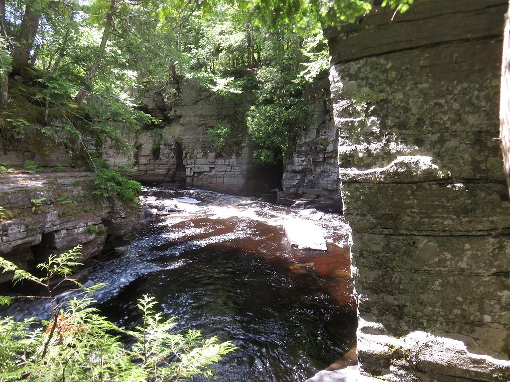
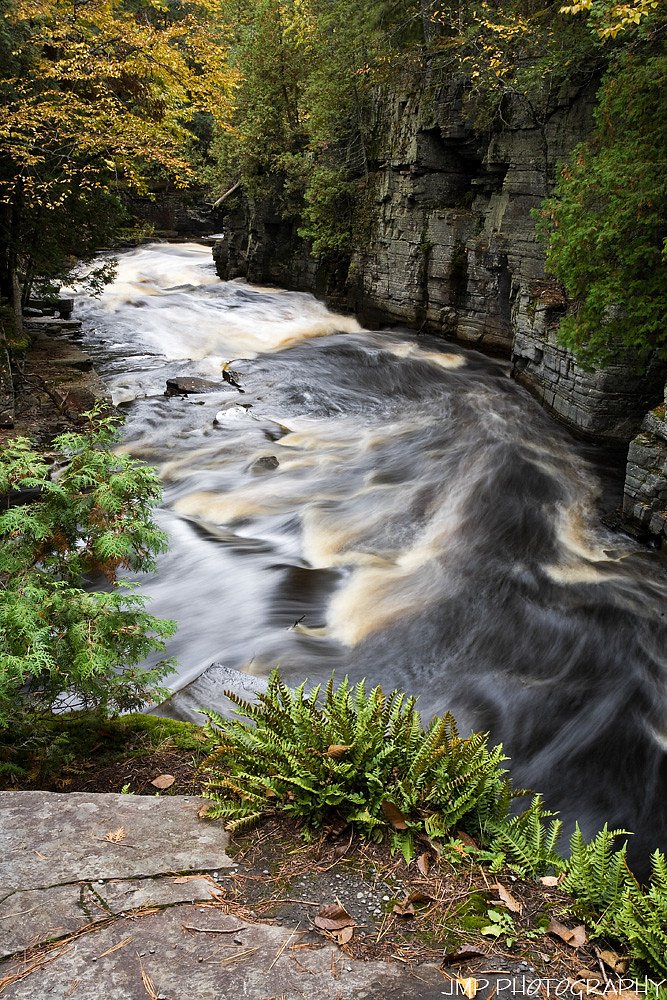
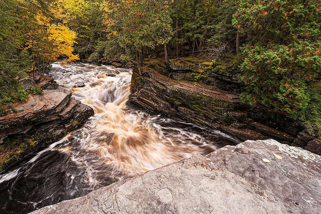
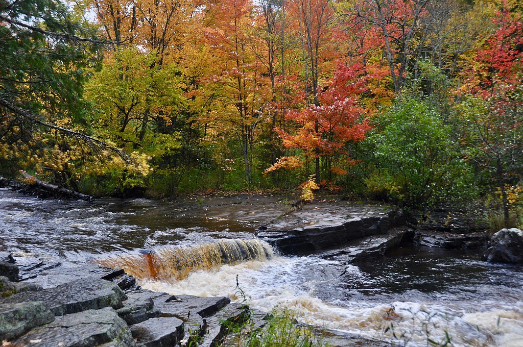
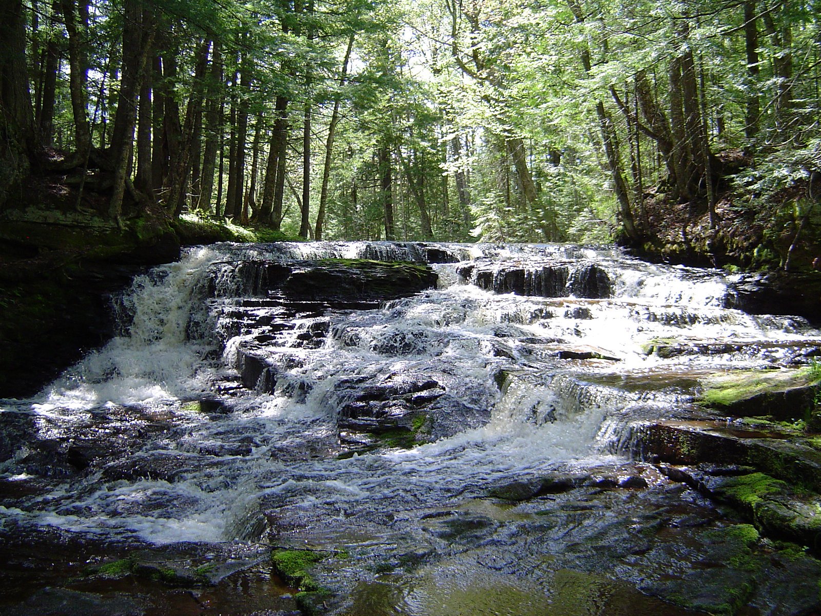
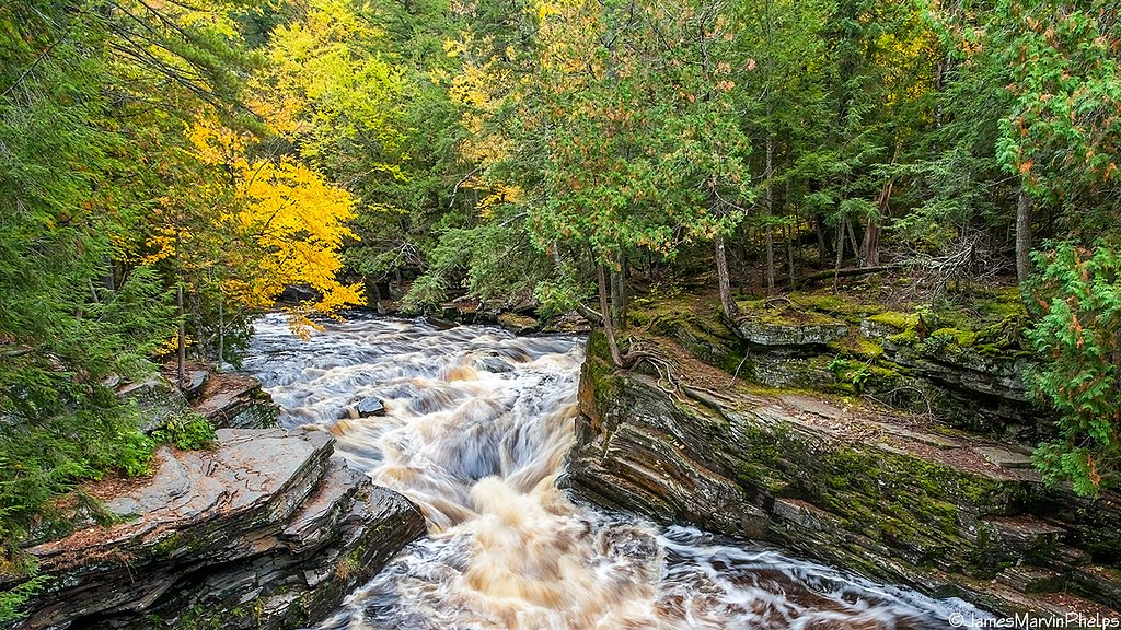
About Sturgeon Falls
Sturgeon Falls is a picturesque waterfall located on the Sturgeon River in Michigan's Upper Peninsula. It is known for its cascading waters and scenic surroundings, making it a popular spot for nature enthusiasts and photographers.
The Setting
Sturgeon Falls sits at 912 feet within Ottawa National Forest, fed by the Sturgeon River, in the foothills of Michigan.
Trail & Hike Details
The Approach
The moderate hike follows Sturgeon Falls (#60017), a 2.4-mile out-and-back trail over natural surface. Expect 350 feet of elevation gain with grades of 8-10%. The trail is developed (Class 3).
USFS Trail
STURGEON FALLS #60017
Trail Class
Developed
Surface
Avg Grade
USFS Segment
0.80 miTrail Description
The trail to Sturgeon Falls is a relatively short and easy hike through a forested area. The path is well-marked and leads to a viewing area near the falls. Visitors may encounter some uneven terrain, but the trail is generally manageable for most skill levels.
What to Expect
Dogs are welcome.
Accessibility
The trail is not wheelchair accessible. Uneven terrain and elevation changes require steady footing.
Frequently Asked Questions
🐶 Are Dogs Allowed at Sturgeon Falls?
✅ Dogs are allowed
Are There Any Fees or Permits Required?
🆖 No fees required
🏊 Is There Swimming at Sturgeon Falls?
❌ Swimming is not allowed
When to Visit
Spring and early summer are the best times to visit Sturgeon Falls due to higher water flow. Fall offers stunning foliage, while winter provides a unique view of the frozen falls.
Seasonal Access
The best time to visit is Spring, Summer, and Fall. Winter access may be limited. Check with Ottawa National Forest for seasonal road closures.
Safety Information
Exercise caution near the falls as rocks can be slippery. Be aware of changing weather conditions and avoid visiting during heavy rain or snowstorms.
Current Water Conditions
293 ft³/s
Current discharge — how much water is flowing
About average for this time of year
Based on 93 years of record
4.41 ft
Water depth at gauge
70°F
CoolRefreshing for swimming
7-Day Discharge Trend
What does this mean for your visit?
Flow is about average for this time of year. Water temperature is a refreshing 70 degrees F, good for a quick swim.
About This Gauge
This gauge is on a nearby waterway and may not reflect exact conditions at the falls.
7-Day Flow Outlook
Based on the USGS gauge STURGEON RIVER NEAR ALSTON, MI (10 km away).
Today
Low
334 cfs
3/10Tomorrow
Low
364 cfs
3/10Wed
Low
351 cfs
3/10Thu
Low
346 cfs
3/10Fri
Low
349 cfs
3/10Sat
Low
305 cfs
3/10Sun
Low
319 cfs
3/10Best window: Today — low flow, showers and thunderstorms likely then mostly cloudy (trip score 3/10).
Best time of year: this gauge typically runs highest from late March to mid June, peaking in April.
How we calculate this
This is a transparent outlook, not a precise forecast. We take the waterfall's current flow strength (how it ranks against its historical normal for today, from the nearest USGS stream gauge), carry that ranking forward along the gauge's seasonal curve, and nudge it for forecast rain. Confidence is highest for the next day or two and falls further out. Always check official conditions and your own judgment before visiting — high flows can be dangerous.
Know when to go.
Get a free email alert when waterfalls near Pelkie hit peak flow. We only send when conditions are worth the trip — no weekly newsletters, no spam.
Weather Forecast
Location & Access
Getting There
Sturgeon Falls is located within the Ottawa National Forest in Michigan's Upper Peninsula. The falls can be accessed via Forest Road 2200 and a short hike from the parking area.
Get Directions on Google MapsParking
There is a small parking area near the trailhead, but availability may be limited during peak seasons.
Elevation
912 feet above sea level
Coordinates
46.642317° N, -88.693123° W
Land Management
Managed by USFS
Visitor Tips & Gear
Wear sturdy footwear as the trail may be muddy or slippery, especially after rain. Bring insect repellent during summer months to protect against mosquitoes. Arrive early during peak seasons to secure parking.
As an Amazon Associate, we earn from qualifying purchases.
With 2.4 miles and 350 ft of elevation gain, sturdy boots and trekking poles will help on this moderate trail. Sun exposure on the trail makes good sun protection a must in summer.

Polarized Sunglasses (Knockaround)
Cuts glare off the water so you actually see the falls — and your photos turn out better too.

Columbia Watertight II Rain Jacket
Packs into its own pocket, seam-sealed, and keeps you dry from spray and surprise rain.

Earth Pak Waterproof Dry Bag
Keeps your phone and gear dry when waterfall mist soaks everything else.

Waterproof Phone Pouch (AiRunTech)
Cheap insurance — take photos right next to the falls without killing your phone.

Timberland Euro Sprint Mid Waterproof
Trusted waterproof boot with premium leather and grippy rubber sole — reliable on rocky, wet trails.

TrailBuddy Trekking Poles
Lightweight aluminum, cork grips, and flip-locks that actually hold — a best-seller for good reason.
Where to Stay

Two Rivers Motel and Cabins of Kenton, MI

Tiny Woodland Cottage Retreat with Yard in Pelkie

UP Escape in the Pines

Jake's Bed & Bar
Browse vacation cabins and private rentals nearby
Unique outdoor stays — tents, yurts, and treehouses
Rent a campervan or RV for your waterfall road trip
Some links are affiliate links. We may earn a commission at no extra cost to you.
Nearby Campground
Sturgeon River Gorge Wilderness
1.7 miles away · 0 sites
The Wild and Scenic Sturgeon River rushes out of the northern portion of this wilderness, over the 20 foot volcanic outcroppings of Sturgeon Falls, and through a gorge that reaches 350 feet in depth and a mile in width. Throughout this rugged, steep Wilderness, the Sturgeon and Little Silver Rivers and their tributaries have carved falls, rapids, ponds, oxbows, and terraces. Stunning views are possible from the eastern rim of the gorge. Except for a few naturally bare slopes, most of the land is
Book on Recreation.govAdditional Information
Nearby Attractions
Other attractions in the Ottawa National Forest include Bond Falls and Agate Falls, as well as numerous hiking trails and scenic viewpoints.
Wildlife
The area is home to a variety of wildlife, including deer, birds, and occasionally black bears. Visitors should exercise caution and follow wildlife safety guidelines.
Cities near Sturgeon Falls
Nearby Waterfalls
Other waterfalls named Sturgeon Falls
2 other waterfalls share this name across the U.S.
Writing about Sturgeon Falls? Embed this waterfall on your site for free.