Difficulty
Moderate
Trail Length
2.4 miles
Trail Type
Out And Back
Elevation Gain
350 ft
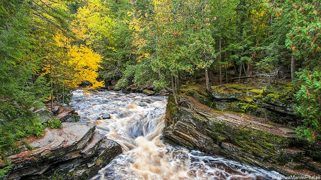
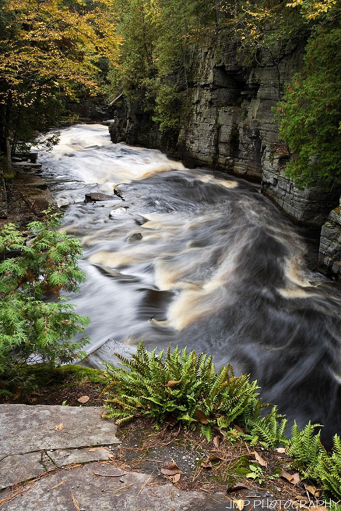
About Tibbets Falls
Tibbets Falls is a small, picturesque cascade tucked into Michigan’s Upper Peninsula and set on tributaries of the Escanaba River. The falls sit within the Baraga State Forest Area (designation: SCA) and are managed by the SDNR, so the setting feels remote and forested—a peaceful spot for photographers and hikers looking for classic UP woodland scenery. The walk in rewards you with a quiet, tree‑lined approach through mixed northern hardwoods. The route is a moderate 2.4‑mile out‑and‑back with about 350 feet of elevation gain, making it a satisfying half‑day outing for hikers comfortable with some uphill sections. If you’d like to camp nearby, the Sturgeon River Gorge Wilderness campground lies about 9.39 km away, offering a natural base for a longer stay in the area.
The Setting
Tibbets Falls sits at 1,198 feet within Baraga State Forest Area, fed by the Sturgeon River, in the foothills of Michigan.
Trail & Hike Details
The Approach
The moderate 2.4-mile out-and-back trail gains 350 feet of elevation on the way to the falls.
Trail Description
Out‑and‑back, 2.4 miles round trip with approximately 350 feet of elevation gain; rated moderate. The trail follows a shaded, forested corridor to the falls and includes some steeper pitches—expect a steady but manageable climb rather than a flat stroll. Sections can be muddy or uneven after rain, so sturdy footwear and basic trail caution are advisable.
What to Expect
Dogs are welcome.
Accessibility
The trail is not wheelchair accessible. Uneven terrain and elevation changes require steady footing.
Frequently Asked Questions
🐶 Are Dogs Allowed at Tibbets Falls?
✅ Dogs are allowed
Are There Any Fees or Permits Required?
🆖 No fees required
🏊 Is There Swimming at Tibbets Falls?
❌ Swimming is not allowed
When to Visit
Spring and early summer are ideal times to visit, as the water flow is typically stronger due to snowmelt and rainfall.
Seasonal Access
The best time to visit is Spring, Summer, and Fall. Winter access may be limited.
Safety Information
Visitors should exercise caution near the water, as rocks can be slippery. Be aware of changing weather conditions, and avoid the trail during heavy rain or snow.
Current Water Conditions
88 ft³/s
Current discharge — how much water is flowing
About average for this time of year
Based on 86 years of record
4.09 ft
Water depth at gauge
7-Day Discharge Trend
What does this mean for your visit?
Flow is about average for this time of year.
About This Gauge
7-Day Flow Outlook
Based on the USGS gauge STURGEON RIVER NEAR SIDNAW, MI (1 km away).
Today
Low
100 cfs
3/10Tomorrow
Low
120 cfs
3/10Wed
Low
110 cfs
3/10Thu
Low
106 cfs
3/10Fri
Low
103 cfs
3/10Sat
Low
95 cfs
3/10Sun
Low
80 cfs
4/10Best window: Sun — low flow, chance rain showers (trip score 4/10).
Best time of year: this gauge typically runs highest from late March to early June, peaking in April.
How we calculate this
This is a transparent outlook, not a precise forecast. We take the waterfall's current flow strength (how it ranks against its historical normal for today, from the nearest USGS stream gauge), carry that ranking forward along the gauge's seasonal curve, and nudge it for forecast rain. Confidence is highest for the next day or two and falls further out. Always check official conditions and your own judgment before visiting — high flows can be dangerous.
Know when to go.
Get a free email alert when waterfalls near Covington hit peak flow. We only send when conditions are worth the trip — no weekly newsletters, no spam.
Weather Forecast
Location & Access
Getting There
Tibbets Falls is located near Gwinn, Michigan, in the Upper Peninsula. Access is typically via forest roads, and visitors should check local maps or GPS for the most accurate directions.
Get Directions on Google MapsParking
Parking is available near the trailhead, but it may be limited. Visitors should plan to park along the roadside if designated spaces are full.
Elevation
1,198 feet above sea level
Coordinates
46.579939° N, -88.589026° W
Land Management
Managed by SDNR
Visitor Tips & Gear
Wear sturdy shoes as the trail can be muddy. Bring bug spray during the summer months to protect against mosquitoes. Check weather conditions before visiting, as the trail may be more challenging after heavy rain.
As an Amazon Associate, we earn from qualifying purchases.
With 2.4 miles and 350 ft of elevation gain, sturdy boots and trekking poles will help on this moderate trail. Sun exposure on the trail makes good sun protection a must in summer.

Columbia Watertight II Rain Jacket
Packs into its own pocket, seam-sealed, and keeps you dry from spray and surprise rain.

Earth Pak Waterproof Dry Bag
Keeps your phone and gear dry when waterfall mist soaks everything else.

Waterproof Phone Pouch (AiRunTech)
Cheap insurance — take photos right next to the falls without killing your phone.

Timberland Euro Sprint Mid Waterproof
Trusted waterproof boot with premium leather and grippy rubber sole — reliable on rocky, wet trails.

TrailBuddy Trekking Poles
Lightweight aluminum, cork grips, and flip-locks that actually hold — a best-seller for good reason.

Polarized Sunglasses (Knockaround)
Cuts glare off the water so you actually see the falls — and your photos turn out better too.
Where to Stay

Two Rivers Motel and Cabins of Kenton, MI

UP Escape in the Pines

Tiny Woodland Cottage Retreat with Yard in Pelkie

Jake's Bed & Bar
Browse vacation cabins and private rentals nearby
Unique outdoor stays — tents, yurts, and treehouses
Rent a campervan or RV for your waterfall road trip
Some links are affiliate links. We may earn a commission at no extra cost to you.
Nearby Campground
Sturgeon River Gorge Wilderness
5.8 miles away · 0 sites
The Wild and Scenic Sturgeon River rushes out of the northern portion of this wilderness, over the 20 foot volcanic outcroppings of Sturgeon Falls, and through a gorge that reaches 350 feet in depth and a mile in width. Throughout this rugged, steep Wilderness, the Sturgeon and Little Silver Rivers and their tributaries have carved falls, rapids, ponds, oxbows, and terraces. Stunning views are possible from the eastern rim of the gorge. Except for a few naturally bare slopes, most of the land is
Book on Recreation.govAdditional Information
Nearby Attractions
Other waterfalls in the Upper Peninsula, such as Laughing Whitefish Falls and Dead River Falls, are within driving distance. The nearby town of Gwinn offers dining and lodging options.
Wildlife
The area is home to a variety of wildlife, including deer, birds, and small mammals. Visitors should be cautious of ticks and other insects.
Cities near Tibbets Falls
Nearby Waterfalls

Writing about Tibbets Falls? Embed this waterfall on your site for free.