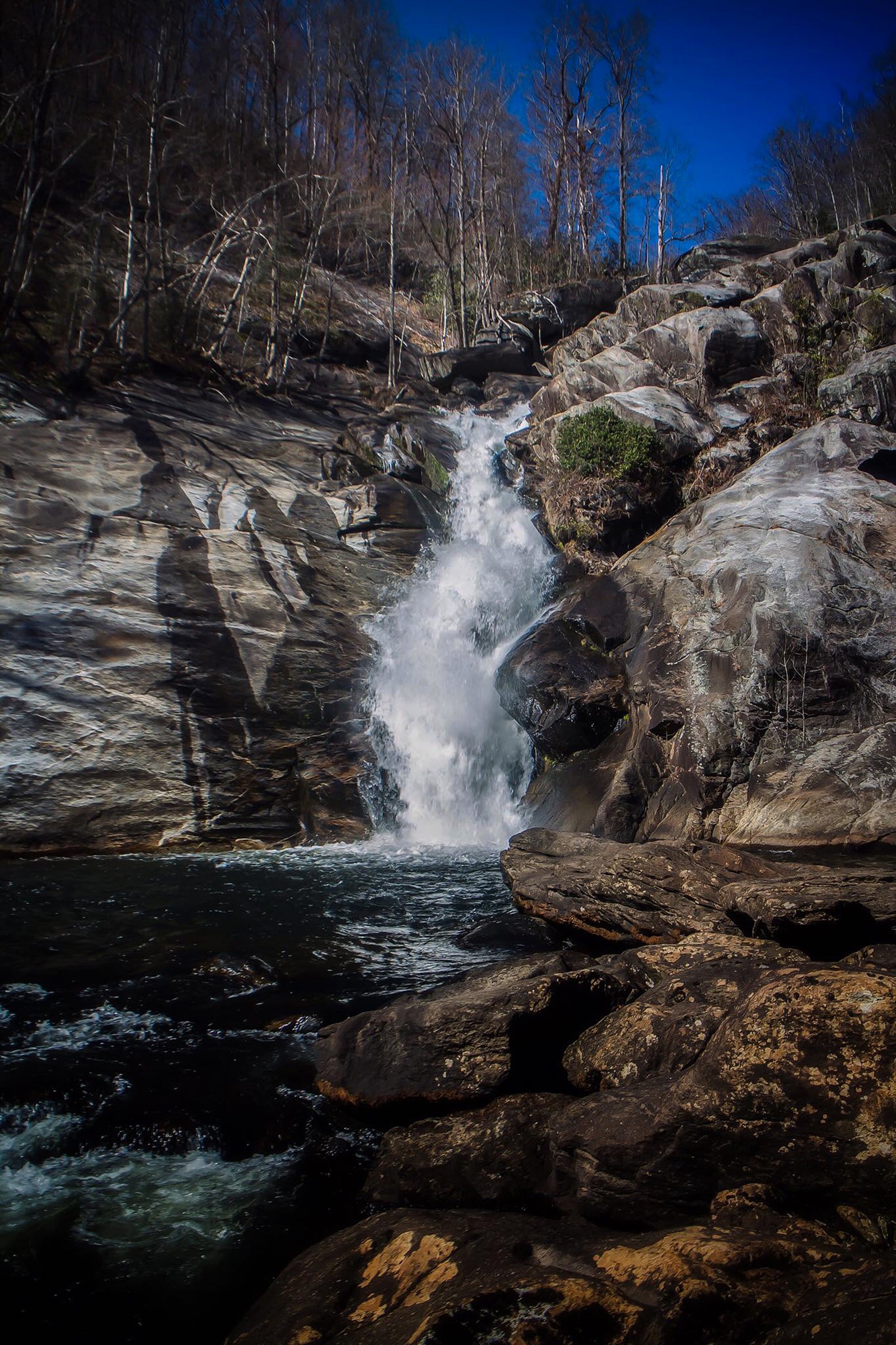
Windy Falls
By Armen Suny · Last verified May 2026

Photo Credits (1)
Difficulty
Moderate
Trail Length
2.4 miles
Trail Type
Out And Back
Elevation Gain
350 ft
About Windy Falls
Windy Falls sits in a remote, rugged pocket of western North Carolina within the Toxaway Game Land (designation: SCA), on land owned by SFW. The falls are known for dramatic cascades and a sense of wilderness that rewards experienced hikers and scramblers — expect steep, rocky approaches and a quiet, unmaintained setting rather than a developed viewpoint. The site is commonly described by local adventurers as a backcountry destination best visited prepared for navigation and routefinding. The broader Southern Appalachian region that hosts Windy Falls is home to a number of protected waterways and wild river corridors; for example, the nearby landscape type includes rivers such as the Horsepasture River, an 18.1-mile National Wild and Scenic river that rises in Jackson County and flows through the Jocassee Gorges to Lake Jocassee. That same regional network of protected lands — including portions of Pisgah National Forest — helps preserve the rugged character visitors find at Windy Falls. Note that the managing agency/land manager for the immediate site is listed as unknown in available records, so plan accordingly and respect Toxaway Game Land rules while visiting.
The Setting
Windy Falls sits at 2,139 feet within Toxaway Game Land, fed by the French Broad River, in the hills of North Carolina.
Nearby Falls Worth Visiting
Whitewater Falls, the tallest waterfall in North Carolina at 411 feet, lies 4.0 miles to the east. Also nearby: Rainbow Falls (150 ft, 1.2 mi).
Trail & Hike Details
The Approach
The moderate 2.4-mile out-and-back trail gains 350 feet of elevation on the way to the falls.
Trail Description
Trail length: 2.4 miles round-trip; elevation gain: ~350 ft; difficulty: moderate; trail type: out-and-back. The route to Windy Falls is unmarked and unmaintained, requiring solid navigation skills, comfortable footing on steep descents and rocky sections, and caution through dense forest. Expect a natural, often uneven surface with short, steep pitches rather than a graded or improved tread; no USFS trail name or number was provided in the available data. The area is remote and cell service may be unreliable — bring a map, compass/GPS, and footwear appropriate for slippery rock and stream crossings.
What to Expect
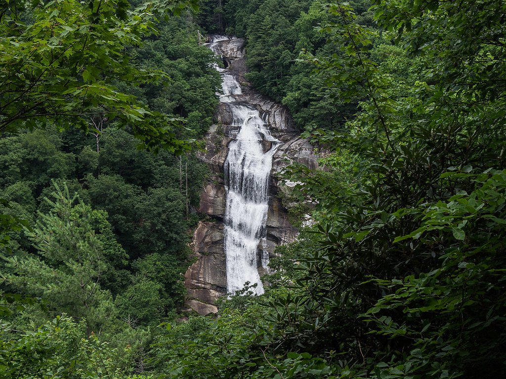
Visitors can expect a challenging hike with stunning views of the waterfall and surrounding forest. The falls feature a series of cascades over large rock formations. The area is rugged and not developed for tourism, so it offers a secluded and natural experience.
Accessibility
The trail is not wheelchair accessible. Uneven terrain and elevation changes require steady footing.
Frequently Asked Questions
🐶 Are Dogs Allowed at Windy Falls?
❌ Dogs are not allowed
Are There Any Fees or Permits Required?
🆖 No fees required
🏊 Is There Swimming at Windy Falls?
❌ Swimming is not allowed
When to Visit
Spring and fall are ideal for visiting due to cooler temperatures and vibrant foliage. Summer can be hot and humid, while winter may bring icy conditions.
Seasonal Access
The best time to visit is Spring, Summer, and Fall. Winter access may be limited.
Safety Information
The trail is unmaintained and can be dangerous. Steep drops, slippery rocks, and strong currents near the falls pose significant hazards. Visitors should exercise extreme caution and avoid the area during or after heavy rain.
Current Water Conditions
84 ft³/s
Current discharge — how much water is flowing
Much lower than usual for this time of year
Based on 91 years of record
2.05 ft
Water depth at gauge
7-Day Discharge Trend
What does this mean for your visit?
Flow is well below normal for this time of year, so the waterfall may be a trickle.
About This Gauge
This gauge is on a nearby waterway and may not reflect exact conditions at the falls.
7-Day Flow Outlook
Based on the USGS gauge FRENCH BROAD RIVER AT ROSMAN, NC (14 km away).
Today
Barely Flowing
84 cfs
5/10Tomorrow
Low
91 cfs
3/10Fri
Barely Flowing
88 cfs
5/10Sat
Low
93 cfs
3/10Sun
Low
99 cfs
3/10Mon
Low
99 cfs
3/10Tue
Low
96 cfs
3/10Best window: Today — barely flowing flow, sunny (trip score 5/10).
Best time of year: this gauge typically runs highest from mid February to early May, peaking in March.
How we calculate this
This is a transparent outlook, not a precise forecast. We take the waterfall's current flow strength (how it ranks against its historical normal for today, from the nearest USGS stream gauge), carry that ranking forward along the gauge's seasonal curve, and nudge it for forecast rain. Confidence is highest for the next day or two and falls further out. Always check official conditions and your own judgment before visiting — high flows can be dangerous.
Know when to go.
Get a free email alert when waterfalls near Cashiers hit peak flow. We only send when conditions are worth the trip — no weekly newsletters, no spam.
Weather Forecast
Location & Access
Getting There
Windy Falls is located near Lake Toxaway in Transylvania County, North Carolina. Access to the falls is not officially marked, and the trail is unmaintained and difficult to navigate. Visitors typically start from the Gorges State Park area or nearby trailheads.
Get Directions on Google MapsParking
Parking is limited and may require using nearby parking areas such as those in Gorges State Park. Visitors should plan ahead and ensure they are parked legally.
Elevation
2,139 feet above sea level
Coordinates
35.075096° N, -82.957919° W
Land Management
Managed by UNK
Visitor Tips & Gear
Wear sturdy hiking boots and bring a map or GPS device. Start early to allow plenty of time for the hike. Be prepared for steep and slippery sections, especially after rain. Avoid hiking alone and let someone know your plans.
As an Amazon Associate, we earn from qualifying purchases.
With 2.4 miles and 350 ft of elevation gain, sturdy boots and trekking poles will help on this moderate trail. Sun exposure on the trail makes good sun protection a must in summer.

Polarized Sunglasses (Knockaround)
Cuts glare off the water so you actually see the falls — and your photos turn out better too.

Columbia Watertight II Rain Jacket
Packs into its own pocket, seam-sealed, and keeps you dry from spray and surprise rain.

Earth Pak Waterproof Dry Bag
Keeps your phone and gear dry when waterfall mist soaks everything else.

Waterproof Phone Pouch (AiRunTech)
Cheap insurance — take photos right next to the falls without killing your phone.

Timberland Euro Sprint Mid Waterproof
Trusted waterproof boot with premium leather and grippy rubber sole — reliable on rocky, wet trails.

TrailBuddy Trekking Poles
Lightweight aluminum, cork grips, and flip-locks that actually hold — a best-seller for good reason.
Where to Stay

Foxhunt at Sapphire Valley

Fairway Forest

The Wells Cashiers

Spectacular Mountain Views With Your Own Private Hot Tub!
Browse vacation cabins and private rentals nearby
Unique outdoor stays — tents, yurts, and treehouses
Rent a campervan or RV for your waterfall road trip
Some links are affiliate links. We may earn a commission at no extra cost to you.
Nearby Campground
BALSAM LAKE LODGE
13.7 miles away · 1 sites
Overview Balsam Lake Lodge is nestled in the center of the 39,000-acre Roy Taylor Forest within the Nantahala National Forest. The lodge overlooks Balsam Lake and offers spectacular mountain views.The lodge opened its doors to the public when the Forest Service acquired the dwelling and lake in 1982. Since then groups have rented the lodge for meetings, recreation and environmental activities. NOTE: Balsam Lake Lodge is not a campground and has no campsites available for sewer, water, or electric
Book on Recreation.govAdditional Information
Nearby Attractions
Gorges State Park, Rainbow Falls, and Turtleback Falls are nearby attractions worth visiting.
Wildlife
The area is home to diverse wildlife, including deer, black bears, and various bird species. Be cautious and respect wildlife habitats.
Cities near Windy Falls
Nearby Waterfalls

Writing about Windy Falls? Embed this waterfall on your site for free.