Photo Credits (5)
Difficulty
Easy
Trail Length
0.5 miles
Trail Type
Out And Back
Elevation Gain
100 ft
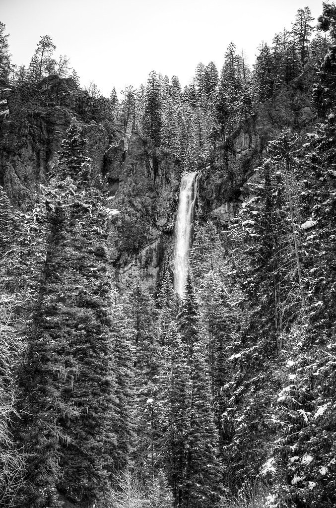
About Silver Falls
Silver Falls is a tucked-away cascade managed by the U.S. Forest Service within the Rio Grande National Forest. The approach rewards a short walk through spruce and aspen with a pleasant view of water tumbling over native rock—especially full in the spring snowmelt—making it a popular half-day stop for hikers and photographers. The route to the falls follows the USFS SILVER MTN Trail (Trail #704), and the setting feels quietly remote while remaining very accessible. If you plan to linger, camping options are nearby: the Fitton Guard Station Cabin is about 7.55 km from the trailhead and provides a convenient base for an overnight stay. Because the trail surface is native material and can be slippery after wet weather, bring sturdy footwear and expect a short, slightly uneven approach rather than a paved promenade.
The Setting
Silver Falls sits at 10,840 feet within Rio Grande National Forest, in the high alpine of Colorado.
Trail & Hike Details
The Approach
The easy hike follows Silver Mtn (#704), a 0.5-mile out-and-back trail over natural surface. Expect 100 feet of elevation gain with grades of 12-20%. The trail is developed (Class 3).
USFS Trail
SILVER MTN #704
Trail Class
Developed
Surface
Avg Grade
USFS Segment
11.24 miTrail Description
The primary access to Silver Falls is a short 0.5-mile out-and-back with roughly 100 feet of elevation gain, rated easy. The approach follows the USFS SILVER MTN Trail (Trail #704). According to USFS trail data the SILVER MTN corridor is class 3 with a native-material surface and a typical grade of 12–20%; USFS GIS listings also record 11.24 miles for the trail system segment. Expect natural tread (roots, rocks, occasional steeper pitches), brief scrambling or use of hands where the grade increases, and potentially muddy sections after rain—appropriate footwear and a cautious pace are recommended.
What to Expect
Dogs are welcome.
Accessibility
The trail is short and relatively flat, but the surface may be uneven. Contact the managing agency for accessibility details.
Frequently Asked Questions
🐶 Are Dogs Allowed at Silver Falls?
✅ Dogs are allowed
Are There Any Fees or Permits Required?
🆖 No fees required
🏊 Is There Swimming at Silver Falls?
❌ Swimming is not allowed
When to Visit
The best time to visit Silver Falls is during late spring or early summer when the snowmelt enhances the waterfall's flow. Fall also offers beautiful foliage in the surrounding forest.
Seasonal Access
The best time to visit is Spring, Summer, and Fall. Access roads and trails may close during winter due to snow. Check with Rio Grande National Forest for seasonal road closures.
Safety Information
Visitors should exercise caution on the trail, especially after rain, as it can become slippery. The road to the trailhead may be hazardous for low-clearance vehicles. Always check weather and road conditions before visiting.
Know when to go.
Get a free email alert when waterfalls near Del Norte hit peak flow. We only send when conditions are worth the trip — no weekly newsletters, no spam.
Weather Forecast
Location & Access
Getting There
Silver Falls is located approximately 15 miles northeast of Pagosa Springs, Colorado. To access the falls, visitors typically take East Fork Road (Forest Road 667), which is a rough dirt road requiring a high-clearance vehicle, especially during wet conditions.
Get Directions on Google MapsParking
There is limited parking available near the trailhead. Visitors should be prepared for a small, unpaved parking area.
Elevation
10,840 feet above sea level
Coordinates
37.421950° N, -106.449203° W
Land Management
Managed by USFS
Visitor Tips & Gear
Check road conditions before visiting, as East Fork Road can become impassable during wet weather. Bring sturdy footwear, as the trail may be muddy. A high-clearance vehicle is recommended for reaching the trailhead.
This trail sits at 10,840 ft — roughly 30% less oxygen than sea level
Extreme AltitudeAt this elevation, altitude sickness is a real concern. Monitor how you feel, take frequent rest breaks, and descend if symptoms worsen. Visitors arriving from lower elevations should allow time to acclimatize.
As an Amazon Associate, we earn from qualifying purchases.

Coppertone Sport SPF 50 Sunscreen
UV intensity jumps ~4% per 1,000 ft — at this elevation you can burn in half the time.

Sun Bum SPF 30 Lip Balm (3-Pack)
Lips have almost no natural UV protection and burn fast in thin, dry mountain air.

Liquid I.V. Electrolyte Packets
You lose moisture ~2x faster at elevation — electrolytes help you absorb water efficiently.

ROCKNIGHT Polarized UV400 Sunglasses
High-altitude glare off rock and water is intense — UV400 lenses block 99%+ of UVA/UVB.

Boost Oxygen 10L Canister (2-Pack)
Portable supplemental oxygen for quick relief from headaches and shortness of breath.

Altitude Rx OxyBoost Complex
Antioxidant formula designed to support your body's natural altitude acclimation.

Fingertip Pulse Oximeter
Monitor blood oxygen in real time — SpO2 commonly drops to 85–90% above 10,000 ft.
As an Amazon Associate, we earn from qualifying purchases.
For this easy 0.5 miles trail, lightweight trail shoes and a water bottle are usually sufficient. Sun exposure on the trail makes good sun protection a must in summer.

Polarized Sunglasses (Knockaround)
Cuts glare off the water so you actually see the falls — and your photos turn out better too.

Columbia Watertight II Rain Jacket
Packs into its own pocket, seam-sealed, and keeps you dry from spray and surprise rain.

Earth Pak Waterproof Dry Bag
Keeps your phone and gear dry when waterfall mist soaks everything else.

Waterproof Phone Pouch (AiRunTech)
Cheap insurance — take photos right next to the falls without killing your phone.

JOBY GorillaPod Starter Kit
Wraps around railings and rocks for long-exposure waterfall shots — no flat surface needed.

Osprey Daylite Daypack
Light, organized, and just the right size for a day hike — fits water, snacks, and layers.
Where to Stay

Holiday Inn Express & Suites Alamosa by IHG

Comfort Inn & Suites Alamosa

Dunes Inn Alamosa

Coyote
Browse vacation cabins and private rentals nearby
Unique outdoor stays — tents, yurts, and treehouses
Rent a campervan or RV for your waterfall road trip
Some links are affiliate links. We may earn a commission at no extra cost to you.
Nearby Campground
FITTON GUARD STATION CABIN
4.7 miles away · 1 sites
Overview Fitton Guard Station is a small cabin located in a high elevation meadow at 10,600 feet on Burro Creek near along an off-highway vehicle trail. The cabins are only accessible by 50" width or less vehicles and non-motorized uses (e.g. foot or horseback). YOU CANNOT DRIVE A PASSENGER VEHICLE TO THE CABINS.Visitors may reserve the cabin for a maximum of 14 days to allow others the opportunity to rent the cabin. The combination to the cabin is provided in the confirmation letter.Recreation T
Book on Recreation.govNearby Hot Springs
Hot springs near Del Norte, Colorado

Shaw Springs
Shaw Springs emerges at 86 degrees Fahrenheit where Rio Grande County's high plateau meets the San Juan Mountains. At 7,971 fee...
Rainbow Hot Springs
Rainbow Hot Springs beckons adventurous soakers willing to undertake a substantial backcountry journey in the San Juan Mountain...
Splashland Hot Springs
Splashland Hot Springs reaches 40.5 degrees Celsius (105 degrees Fahrenheit) at just 13 meters from a gravel road near Alamosa ...

Pagosa Springs
Pagosa Springs (known as The Mother Spring) flows at 136°F in Archuleta County as the primary emergence point for the geotherma...
Pagosa Hot Springs
Pagosa Hot Springs holds local lore as the world's deepest known geothermal spring system, with thermal water emerging near roa...

Wagon Wheel Gap Hot Springs
Wagon Wheel Gap Hot Springs emerges at 135 degrees Fahrenheit in the upper Rio Grande River valley near the historic mining tow...
Looking for a soak after your hike? Explore more hot springs near Del Norte, Colorado on SoakingSprings.
Explore Colorado springsAdditional Information
Nearby Attractions
Pagosa Springs, East Fork San Juan River, and the San Juan National Forest.
Wildlife
The area is home to various wildlife, including deer, birds, and small mammals. Visitors should be cautious of bears and other larger wildlife.
Cities near Silver Falls
Other waterfalls named Silver Falls
16 other waterfalls share this name across the U.S.
Writing about Silver Falls? Embed this waterfall on your site for free.