Photo Credits (3)
Difficulty
Easy
Trail Length
0.8 km
Trail Type
Out And Back
Elevation Gain
22 m
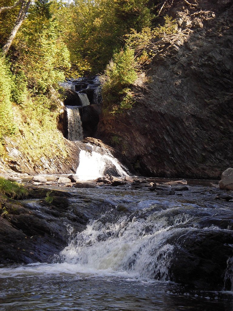
About Silver Falls
Silver Falls is a small, forested waterfall site in southern New Brunswick near Saint John. The falls are set in a mixed hardwood-conifer forest and are likely most impressive in spring and after periods of heavy rain. Exact official height and detailed topographic data for this site are not confidently confirmed here.
Why This Waterfall Exists
Silver Falls flows over layered sedimentary rock laid down about 252-539 million years ago. Over time, the stream has worn through these layers at different rates, creating the step that forms the waterfall.
Trail & Hike Details
The Approach
The easy 0.8-km out-and-back trail gains 22 metres of elevation on the way to the falls.
Trail Description
Trail information for this specific Silver Falls location is not comprehensively documented here. Visitors should expect an informal footpath from the parking/pullout into a forested area down to the stream. Trails may be natural surface, possibly with roots, rocks and short, steeper sections near the falls. There may be no maintained boardwalks, handrails, or signage.
What to Expect
A modest waterfall in a wooded setting. Water volume can vary seasonally, typically higher in spring and after rains, lower in late summer during dry spells. Expect muddy or slippery trail sections, exposed roots and rocks, and potentially steep banks near the water. Limited facilities: likely no restrooms, picnic tables, or official viewpoints. Mobile phone service may be spotty in the immediate valley.
Accessibility
The trail is short and relatively flat, but the surface may be uneven. Contact the managing agency for accessibility details.
Frequently Asked Questions
🐶 Are Dogs Allowed at Silver Falls?
❌ Dogs are not allowed
Are There Any Fees or Permits Required?
🆖 No fees required
🏊 Is There Swimming at Silver Falls?
❌ Swimming is not allowed
When to Visit
Late spring (snowmelt/after rains) for peak flow and fall for foliage color. Summer visits are common but flows may be lower. Winter access may be icy and hazardous; only attempt with appropriate gear and experience.
Seasonal Access
The best time to visit is Spring, Summer, and Fall. Winter access may be limited. Check with the managing park or local authority for current conditions.
Safety Information
Hazards may include slippery rocks, steep or unstable banks, fast-flowing water after rain, and limited or no railings. Weather can change rapidly. Wear appropriate footwear, avoid getting too close to the edge, supervise children closely, and do not climb on wet ledges. If conditions are icy or stormy, postpone the visit. In case of emergency, cell service may be intermittent, know your general location and the route back to the nearest road.
Current Water Conditions
0.2 m³/s
Current discharge — how much water is flowing
About average for this time of year
Based on 37 years of record
1.15 m
Water depth at gauge
7-Day Discharge Trend
What does this mean for your visit?
Flow is about average for this time of year.
About This Gauge
This gauge is on a nearby waterway and may not reflect exact conditions at the falls.
7-Day Flow Outlook
Based on the WSC gauge BLACK RIVER AT GARNET SETTLEMENT (13 km away).
Today
Low
0.1 m³/s
4/10Tomorrow
Low
0.1 m³/s
5/10Tue
Low
0.1 m³/s
5/10Wed
Low
0.1 m³/s
4/10Thu
Low
0.1 m³/s
4/10Fri
Low
0.1 m³/s
5/10Sat
Low
0.1 m³/s
4/10Best window: Tomorrow — low flow, cloudy (trip score 5/10).
Best time of year: this gauge typically runs highest from late March to mid May, peaking in April.
How we calculate this
This is a transparent outlook, not a precise forecast. We take the waterfall's current flow strength (how it ranks against its historical normal for today, from the nearest WSC stream gauge), carry that ranking forward along the gauge's seasonal curve, and nudge it for forecast rain. Confidence is highest for the next day or two and falls further out. Always check official conditions and your own judgment before visiting — high flows can be dangerous.
Know when to go.
Get a free email alert when waterfalls near Saint John hit peak flow. We only send when conditions are worth the trip — no weekly newsletters, no spam.
Weather Forecast
Location & Access
Getting There
The falls are located near coordinates 45.2966, -66.0105, roughly 6.8 miles from Saint John by road. Expect to reach the general area by secondary or local roads; follow local signage or a GPS mapping app to the nearest access pullout. Final approach may be on a short unpaved spur or rough roadside pullout.
Get Directions on Google MapsParking
Parking is likely limited to a small roadside pullout or informal parking area. There may not be a formal paved lot or facilities. Park off the road safely and not blocking driveways or gates.
Elevation
11 metres above sea level
Coordinates
45.296588° N, -66.010458° W
Visitor Tips & Gear
• Wear sturdy, grippy footwear, rocks and roots can be slippery. • Use caution near the water and on streamside ledges; there may be no barriers. • Bring insect repellent in warmer months. • Pack out all trash; there may be no waste facilities. • If you plan to explore off the main path, exercise extra caution and avoid wet rock faces. • Check local trail reports or contact nearby municipal/park authorities for current access conditions before you go.
As an Amazon Associate, we earn from qualifying purchases.
For this easy 0.8 km trail, lightweight trail shoes and a water bottle are usually sufficient. Sun exposure on the trail makes good sun protection a must in summer.

Polarized Sunglasses (Knockaround)
Cuts glare off the water so you actually see the falls — and your photos turn out better too.

Columbia Watertight II Rain Jacket
Packs into its own pocket, seam-sealed, and keeps you dry from spray and surprise rain.

Earth Pak Waterproof Dry Bag
Keeps your phone and gear dry when waterfall mist soaks everything else.

Waterproof Phone Pouch (AiRunTech)
Cheap insurance — take photos right next to the falls without killing your phone.

JOBY GorillaPod Starter Kit
Wraps around railings and rocks for long-exposure waterfall shots — no flat surface needed.

Osprey Daylite Daypack
Light, organized, and just the right size for a day hike — fits water, snacks, and layers.
Where to Stay
Browse vacation cabins and private rentals nearby
Unique outdoor stays — tents, yurts, and treehouses
Rent a campervan or RV for your waterfall road trip
Some links are affiliate links. We may earn a commission at no extra cost to you.
Nearby Campground
Rockwood Park Campground
3.2 km away
Additional Information
Nearby Attractions
Near Saint John area attractions such as Irving Nature Park and the Reversing Falls (in the city). Fundy coastal areas and provincial parks are within driving distance but check maps for exact distances and directions.
Wildlife
Typical southern New Brunswick wildlife may be present: white-tailed deer, small mammals, songbirds, and potentially black bear or moose in the broader region. Ticks can be a concern in warm months. Exercise standard wildlife precautions.
Cities near Silver Falls
Other waterfalls named Silver Falls
16 other waterfalls share this name across Canada.
Writing about Silver Falls? Embed this waterfall on your site for free.